CityCyclingEdinburgh Forum » Infrastructure

New Cycle Route Signs

(179 posts)
  • Started 10 years ago by HankChief
  • Latest reply from wingpig

  1. wangi
    Member

    rbrtwtmn - key thing is to separate the data from the display. The important data is that there's a signed route for bicycles which avoids the restricted Bypass. So long as the tags / relations along that don't overstate the reality then cool...

    ... The problem really is the map rendering / style sheet then goes on to over represent that. But you don't sort that by changing the data, you need to look at the stylesheets.

    Posted 9 years ago #
  2. chdot
    Admin

    (Not new)

    Posted 9 years ago #
  3. rbrtwtmn
    Member

    Hi wangi.

    (Non OSM mapping / GIS people may want to skip this message completely...)

    You make an excellent point regarding OSM tagging - basically that you don't tag for the rendering. This principle would suggest that we should record that a route exists whatever quality it exhibits, adding data about signs and other qualities in addition to the basic information.

    But I propose that in reality things are a bit more complicated.

    The basic definition of a cycle route in the OSM wiki for example says "Cycle routes... are named or numbered or otherwise signed routes." I'd suggest that in this phrase we're talking about something which exists beyond a set of plans, maps or data. The closest we get to a definition of a route which doesn't really exist on the ground is the idea of a proposed route.

    But you could read things more flexibly I suppose... which brings me to my second and primary point. The key issue is that there is currently no way to tag cycle routes to describe the quality of the signage and more general infrastructure. I'd propose that there won't be one in the near future either. Not only are we rubbing up against very subjective measures, which perhaps don't belong on OSM at all, but we're also trapped a little by the basic 'relation' system used for cycle routes. Unless we start tagging cycle routes as super-relations then tags such as signage quality will need to refer to the whole route. There's no simple way to tag that one bit of route is well signed and another not signed at all.

    So given these things I propose that we're back to the original question. What bits of the RR route actually exist (beyond lines on a map), and which bits don't? And given the general state of the route we have to be a bit less forgiving about what actually 'exists' than we would be if there were two signs on either end of an old railway path or equivalent.

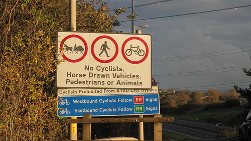
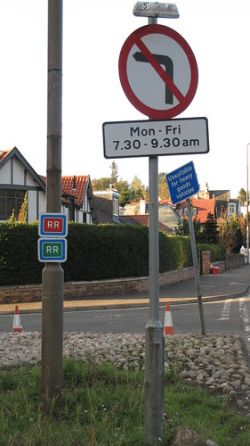
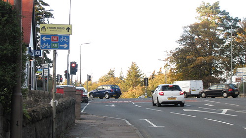
    I do get that the RR route has some signs and in parts definitely should be in the OSM data, but if a majority of them are missing, or all are missing for some areas, then I think we should consider either removing at least some pieces of route from the data, or at the least downgrading them to 'proposed' status.

    Posted 9 years ago #
  4. chdot
    Admin

    "then I think we should consider either removing at least some pieces of route from the data, or at the least downgrading them to 'proposed' status"

    Well...

    There are two different things here.

    1) the subjective nature of OSM - which relies on individual volunteers doing their best.

    2) CEC has either not signed this particular route PROPERLY - or is not making sure that ALL signs still exist (and point the right way...)

    Clearly there is an additional question about whether THIS route is 'sensible'. If so, do it properly. If not remove ALL signs.

    Posted 9 years ago #
  5. rbrtwtmn
    Member

    I'd be interested to hear from anyone who feels it is 'sensible'. It would be nice to hear from someone who genuinely feels like this route is worth anything at all. That's not meant to read in any way like a challenge - I really mean it. My perception of it is that it should never have been created (as it is at least) and that it's a waste of the metal used in the signs, but I'm quite happy to be told I'm wrong by someone who has found it useful in some way.

    Posted 9 years ago #
  6. smsm1
    Member

    @HankChief re Gogar Station Road, it was marked as having a cycle route back in June 2009 based on http://www.openstreetmap.org/way/4477013/history

    I believe that it's been added due to the following signs:
    https://www.google.co.uk/maps/@55.9188788,-3.3142058,3a,37.5y,85.54h,91.61t/data=!3m4!1e1!3m2!1sSFBWT5Xe4nt_hHiwyX_Zmw!2e0?hl=en

    Having been along that road many a time - even back in the days when I was at school - it could probably do with having a 20/30 mph speed limit, if cycling is to be encouraged along there. As it's not a numbered route, I'd probably remove the lcn=yes tags. It is a hard one with these signed routes.

    Posted 9 years ago #
  7. chrisfl
    Member

    I'm with @rbrtwtmn, the route isn't nice to cycle at all, my experience is that a good chunk of it is signed and I'm guessing that whoever has mapped it has probably joined the dots, filling in gaps in the signage.

    In my quick test, the routers tend to avoid it, Cyclestreets on uses the busy part of the RR on it's fastest route: http://www.cyclestreets.net/journey/42714237/

    and cycle.travel also ignores it entirely http://cycle.travel/map/journey/92

    So for the routers the combination of busy roads is enough to tell them not to use it, but that isn't so obvious when looking at a map.

    Posted 9 years ago #
  8. smsm1
    Member

    I used to use the old RR route, and parts of it, though maybe that's because I lived in the South East in Moredun, and went to school in Currie, later I went to uni at Heriot-Watt at Riccarton, though would often take alternative routes as it was a bit busy at times. With some #Space4Cycling and quality cycle tracks along parts of it, it would become a much better route. A reduction of the speed limit along some of the sections would also be good.

    The signs have been there for as long as I can remember, i.e. at least 15 years.

    Posted 9 years ago #
  9. smsm1
    Member

    Cycle.travel uses the the number of vehicles traveling along each major road, hence why it avoids some of the busier roads.

    Posted 9 years ago #
  10. chdot
    Admin

    http://cycle.travel

    Haven't come across that before.

    Posted 9 years ago #
  11. Cyclingmollie
    Member

    I've only used it once about ten years ago. I arranged to meet my wife at Ikea. She drove, I cycled. I chose the RR because I had seen the signs in Millerhill previously (I live in Musselburgh) and assumed it must be a quiet, well thought out route. It was fairly grim - Gilmerton, Captain's Road. I wouldn't go that way now. I think it's supposed to be an alternative to the City Bypass for bikes but it doesn't take account of the fact that the bypass is meant to relive congestion caused by drivers. Cyclists reduce congestion in other ways, not by avoiding the city centre on cross-city journeys. A flawed idea.

    Posted 9 years ago #
  12. PS
    Member

    Agreed, @Cyclingmollie.

    @chdot's first photo above gives an indication of the purpose of the route - cycles aren't allowed on the by-pass, so the RR route offers a reasonably direct route that shadows it.

    There may be a few cyclists who go that way on a regular basis (commuters from Dalkeith to Edinburgh Park?), but they must be pretty hard core cyclists as they're not inviting roads to use.

    However, I'd have thought they are exactly the sorts of roads (arterial) that the Council should be putting segregated cycling infrastructure on if it really is serious about making cycling an easy option for the majority of the population. [I'd need to go back to their streetscape document to check, but I suspect on the basis of that they should all have segregated facilities "where practicable"...]

    Posted 9 years ago #
  13. kaputnik
    Moderator

    The thing is, if the Bypass (bypassing in general) was effective, the roads of the RR should be pretty devoid of anything but light local traffic. Instead I'd wager they are used by people going 1 or 2 "stops" on the Bypass but who reckon it's not a good use of their valuable time to go up to a junction, get on the bypass, then repeat the process when they get to their destination stop.

    There aren't many parts of the RR route where space is too much of an issue, I think the main blocker to those bits of roads being nicer is that they are still use effectively as an inner, vehicular ring route for Edinburgh. And why not, there's not a huge amount of features on it to discourage the canny motorist, saving time and fuel by avoiding the Bypass.

    Posted 9 years ago #
  14. amir
    Member

    I don't find Captain's Road etc too bad (except for the surfaces) and sometimes use them on my commute. It's also the quickest way to the Lang Whang from Midlothian. That said, there are no cycle facilities (apart from maybe advanced stop lines) but there is plenty of space for them. If "they" were serious about the RR designation, they'd have put in wide separated cycle lanes.

    Posted 9 years ago #
  15. smsm1
    Member

    There's definitely space on the RR route to have some high quality safe separated cycle infrastructure. It would be relatively easy to install (with potential removal of car parking along Captain's Road and a few other places). It would also be a nice big project, which is what I thought that politicians liked. It could also be done in stages much like the A720 was built.

    Posted 9 years ago #
  16. HankChief
    Member

    I'm going to try again with a new spot of a shared use sign...

    Glasgow Rd Shared use by HankChief, on Flickr

    It's on the Northside of the Glasgow Road, between the Jaguar garage and the Shell garage, near the new(ish)car wash place.

    I've checked Streetview and it was there this June but not in 2012, so I think it was part of the recent labeling noted when this thread started.

    I had heard that this might have been shared use, but until the sign went up I wasn't sure. Good to see the sign, but there is nothing else to indicate where the shared use starts or stops. I assume it is just the stretch from the toucan at Dechmont Road to the toucan at Maybury Road.

    Family Route 9 uses North Gyle Terrace instead of this path, but at rush hour, this can be a bit uncomfortable with rat running traffic using it to avoid the Maybury Road queues, so this can be useful alternative.

    Now one sign on 450m stretch of shared use path seems a little bit minimalist, but I actually prefer that to having hundred of signs and multiple give way/cyclists dismount signs.

    Posted 9 years ago #
  17. chdot
    Admin

    How do you get to/from it?

    Looks a bit underwhelming even just as a pavement!

    Posted 9 years ago #
  18. HankChief
    Member

    The East end of it is the Toucan crossing over the A8 Glasgow Road by the Jaguar garage/Dechmont Road and the West end is Toucan crossing over Maybury Road by the Shell garage - There are directional signposts at each end but without any arrow pointing in the direction of this path.

    A bit of goggling tells me that it was made shared use path back in 2011 to form part of the Family route 9 providing a continuous off-road cycle route from South Gyle to Newbridge but when they came to signpost it they went for North Gyle Terrace instead.
    I guess they had 2 spare shared use signs and so thought they would stick them up on it.

    Underwhelmed is about right...

    Posted 9 years ago #
  19. acsimpson
    Member

    If they are looking for a spare one they could take the one off Gogar Roundabout Streetview suggests it was installed sometime around 2008-2009.

    Posted 9 years ago #
  20. rbrtwtmn
    Member

    Well done for spotting that!

    Whatever do you mean when you say that cyclists aren't taken seriously in Edinburgh? This shows imaginative thinking about infrastructure. What better way to make sure that evil rule breaking cyclists can't slow any nice motorists down, upset any pedestrians, or similar? This has to take 'unusable' onto a whole new plane.

    OK - lets be fair it has to have been a mistake...

    Can someone who knows the shared use path (the real one) map it on OSM? It's currently missing on the map.

    Posted 9 years ago #
  21. acsimpson
    Member

    I'm sure it was a mistake. It was pointed out on here before but I only just realised that the lampost itself was installed long after the underpass was. I guess it must have been relocated from somewhere with a cycle path.

    Posted 9 years ago #
  22. kaputnik
    Moderator

    Time might be up for Hankchief's favourite signs on the old Pinkhill station platform. Cooncil workies out this mornign installing a handrail at the platform level. (this actually stops you turning right at the bottom of the stairs and continuing along the platform in the direction of the bridge.)

    Posted 8 years ago #
  23. HankChief
    Member

    I saw the new railings at Pinkhill this morning. Appreciate they have more work to do, but they didn't exactly look childproof.

    Do we know if there have been any incidents there or are these preemptive?

    Posted 8 years ago #
  24. chdot
    Admin

    Presumptive...

    Posted 8 years ago #
  25. HankChief
    Member

    Pinkhill Platform Barriers by HankChief, on Flickr

    Posted 8 years ago #
  26. chdot
    Admin

    Yeah, need those on all railway stations...

    Posted 8 years ago #
  27. HankChief
    Member

    Let's not stop there. The canal should be next.

    Posted 8 years ago #
  28. chdot
    Admin

    Shhhh

    Posted 8 years ago #
  29. wingpig
    Member

    Could do with some warning signs and protection railings on NCN1 where it passes Stixwould station, where there is a simultaneous DROP HAZARD to the east and a RIVER HAZARD to the west (02:54).

    [+] Embed the video | Video DownloadGet the Video Plugins

    Posted 8 years ago #

RSS feed for this topic

Reply

You must log in to post.


Video embedded using Easy Video Embed plugin