
Yeah - they also removed the fridge that someone dumped in the subway last night!
CityCyclingEdinburgh Forum » Commuting
"Severe weather warning"
(7486 posts)-
Posted 12 years ago #
-
Posted 12 years ago #
-
Seems to be a lot of rain lately - if this graph and KB weather station are to be believed.
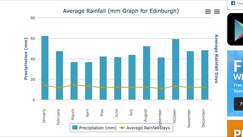
http://www.worldweatheronline.com/Edinburgh-weather-averages/City-Of-Edinburgh/GB.aspx
http://www.geos.ed.ac.uk/abs/Weathercam/station/24hours.html
 Posted 12 years ago #
 -
Huge puddle on Scotstune Ave in South Queensferry, coming well over the line.
Posted 12 years ago # -
Saturday evening is the next projected downpour, just in time for Moonwalk:
... torrential thunderstorms are expected to sweep across the Lothians on Saturday into Sunday morning.Flood alerts are in place for the Edinburgh and the Lothians and the Scottish Borders, which are expected to be hardest hit.
The alerts, issued by Sepa, are currently at the lowest of three warning levels, meaning that “flooding is possible” and the public should “be prepared”.
The Met Office has also urged the public to be aware of the potential for localised flooding due to the intensity of the storms.
They say they expect heavy showers to worsen throughout Saturday with torrential downpours between 4pm and midnight.
A yellow severe weather warning has been issued, meaning there is a moderate risk of some damage to infrastructure and local disruption.
Posted 12 years ago # -
Might just avoid a downpour on the Bethany Sportive. Definitely planning an early start to increase my chances.
Posted 12 years ago # -
"I want to get to the bottom of the situation and find out why it’s happening,” Councillor Cardownie said.
Maybe because it used to be a loch and it will always be a problem? They could give in and turn it into a pond instead.
Posted 12 years ago # -
"
Scattered heavy, thundery downpours are likely to break out from mid-afternoon and last into the evening, across parts of Central and Southern Scotland. Ihese could lead to some localised surface water flooding, particularly on the road network and more especially if the downpours affect urban areas. The public should be aware of the risk of localised disruption to travel and perhaps isolated cases of minor property flooding.Local Authorities affected: Dumfries and Galloway, East Lothian, Edinburgh, Midlothian Council, Scottish Borders, West Lothian
"
Posted 12 years ago # -
Glad I managed to ease in a slightly longer commute via Cramond (even if I did flat out on the glass strewn on the promenade, it was worth it for the insanely good weather).
Looks like it might not be the day to extend the return route, right enough...
Posted 12 years ago # -
Looks ok for now. The forcast for rain is getting later and later in the day as time does on:
http://www.metoffice.gov.uk/public/weather/forecast/gcvwr3yr7
Temsp in the high teens/ low 20s looks ok for a soeaking. Wind is very low, so looks good for a ride in the rain home :D
Posted 12 years ago # -
EdFoC Evening at the Proms ride on.
Covering some of the same ground as covered a few weeks ago. We will be avoiding the more obscure variants of the route - if not the rain.
Posted 12 years ago # -
I'm in! (I hope)
Posted 12 years ago # -
Well, bang goes my 5pm cycle round loch leven. The heavens have just opened over the Fife riviera.
Posted 12 years ago # -
Darn, you home already? or is SWMBO phoning to report in?
Posted 12 years ago # -
It's still dry (but threatening) in the old capital.
Posted 12 years ago # -
pretty wet for past while in polwarth
Posted 12 years ago # -
Got soaked through at 5pm heading out of Leith. Rather unfortunate timing leaving work.
Posted 12 years ago # -
Easter Road was like a shallow river around 5.30pm. The rain was refreshing after spending most of the day in dazzling sunshine on North Berwick beach (yearly nursery school trip with my daughter). 21 degrees centigrade out there (at least).
Posted 12 years ago # -
The rain had eased off by the time I got on my bike last night. Got a bit wet from the spray, and a splash from a passing car, which was really warm and unpleasant.
Posted 12 years ago # -
Hardly got rained on at all... just a bit while we were driving up to Thriepmuir at about 6 - 6:30pm, but it cleared up after no more than 10 minutes.
Posted 12 years ago # -
Lovely and warm lastnight on the Prom ride.
Posted 12 years ago # -
Where did the sun go?!
Did I misread the forecast last night or did it not mention rain?
Posted 12 years ago # -
For Saturday -
"
Yellow warning of rain BE AWARE
Areas of heavy, thundery showers will develop over England and Wales from Friday night before moving northwards into Scotland during Saturday. The location of these is uncertain but where they do form some torrential downpours are possible with frequent lightning, large hail and locally strong gusts. Significant flooding is possible where these do occur from surface water as well as from small, fast responding watercourses. The frequent lightning, large hail and strong gusts could also be an additional hazard. The public should be aware of the risk of disruption from any of these elements. This alert has been updated to extend the area at risk further west.
"
Posted 11 years ago # -
"
Showers and thunderstorms will develop this afternoon and evening across parts of northern and eastern Scotland. Isolated intense downpours will briefly affect a few areas with very localised surface water flooding possible, giving temporary standing water at prone spots.
"
Posted 11 years ago # -
Thunder.
Posted 11 years ago #
Reply »
You must log in to post.
 posts
posts
