CityCyclingEdinburgh Forum » Infrastructure

East Lothian Paths Consulation

(87 posts)
  • Started 10 years ago by Schemieradge
  • Latest reply from Schemieradge

No tags yet.


  1. "... and going for a Sunday afternoon stroll on a sharted use path (having arrived there by car)."

    Sweeping-Generalisations-r-Us

    Ah well, I guess I'll just have to start hating pedestrians as well, and ignoring their worries and concerns, and because my friends are such a small minority we should just ignore them as well and leave them in their broom cupboard.

    Seriously. Pedestrians are not the enemy.

    Pedestrians complain about cyclists and pedestrians always get their way, sounds eerily similar to, cyclists complain about motorists and cyclists get their own way.

    I'm leaving this thread, the paranoia and dislike for more vulnerable users is too much for me to bear.

    Posted 10 years ago #
  2. Min
    Member

    Missing post?

    (that forum thing where you can't see the last post because it is on the next page)

    Posted 10 years ago #
  3. Min
    Member

    and because my friends are such a small minority we should just ignore them as well and leave them in their broom cupboard.

    Umm, no. The punchline to the broom cupboard sentence was the one immediately afterwards. This one:-

    They are probably not the ones making all the noise about cycling while not making any about car speeds.

    And not the one you made up about ignoring them. If I wanted to ignore them I wouldn't be railing against shared use paths.

    Posted 10 years ago #
  4. chdot
    Admin

    "If I wanted to ignore them I wouldn't be railing against shared use paths."

    Good idea.

    Railings up the middle of shared use paths...

    Posted 10 years ago #
  5. Min
    Member

    And talking of paranoia, I was trying to reassure you that you weren't really on a tightrope and talking about conflicting things because I don't believe you are. You may disagree of course (although you even said yourself that speeds don't necessarily make a path dangerous) but it wasn't a deliberate attempt to wind you up, you just took it that way.

    Posted 10 years ago #
  6. Min
    Member

    Railings up the middle of shared use paths...

    Well it might help. Would provide bike parking too. ;-)

    Posted 10 years ago #
  7. Cyclingmollie
    Member

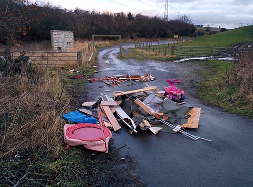
    And here's the facility we are talking about, taken earlier this afternoon:

    Posted 10 years ago #
  8. crowriver
    Member

    Quality bit of fly tipping there!

    Posted 10 years ago #
  9. Cyclingmollie
    Member

    Yep, warm up on the trampette and a few intervals along to the flood and back on the pink quad bike.

    Posted 10 years ago #
  10. Min
    Member

    Surely those are jumps for the horses!

    Posted 10 years ago #
  11. Cyclingmollie
    Member

    Yes, lots for pedestrians, cyclists riders and horses to agree on about that. Drivers too as that's blocking the car park.

    Posted 10 years ago #
  12. minus six
    Member

    They just want it stopped so they can continue to speed in their cars and amble gently along the paths

    with their dogs wandering around off the leash

    no question that they want their cake and eat it

    in all public space / environments

    Posted 10 years ago #
  13. amir
    Member

    Consensus is a great thing, don't you agree?

    Posted 10 years ago #
  14. kaputnik
    Moderator

    The car park there at Smeaton is one of the hardest bits of the path to navigate.

    Posted 10 years ago #
  15. neddie
    Member

    Drem-Gullane path campaign – Jan 22 mtg

    The campaign is holding a public meeting in Gullane to decide on the next steps in the campaign. Relevant Councillors have been invited to the meeting.

    Gullane Village Hall, Wednesday January 22 from 7.30 to 8.30.

    Further details from Iain Monk...
    dgcorepath@gmail.com Twitter @dgcorepath
    Website https://sites.google.com/site/dremgullanepath/
    Newsletter https://sites.google.com/site/dremgullanepath/newsletter

    Becky's Strip path – Jan 28 mtg

    Becky's Strip is an unsurfaced path enabling an offroad connection between North Berwick and East Linton. The Council has proposed surfacing it so that it is suitable for cycling and walking in all weathers, but there have been some objections. The council has now called a public meeting as follows...

    Tuesday 28th January, 2014 at 7pm at Whitekirk Golf & Country Club

    The council says, "this meeting will provide an opportunity for local users and members of the public to discuss the proposed use and options for surface changes to the path."
    Further info...
    Iain Reid, East Lothian Council cycling officer
    Tel 01620 827143
    Email ireid@eastlothian.gov.uk.

    Posted 10 years ago #
  16. chdot
    Admin

    Drem: Previous thread

    Posted 10 years ago #
  17. Schemieradge
    Member

    "The car park there at Smeaton is one of the hardest bits of the path to navigate."

    I hate that bit too.. remember when they tried to "fix" it by dumping a load of small boulders down and raking them about a bit?
    And don't get me started on that stupid gate..

    Anyway - quite proud to have started a thread that's reached it's 3rd page.. I hope you've all got in touch with the consultancy whatever your viewpoint. I think we can agree that at least it needs drainage sorting.

    Posted 10 years ago #
  18. Cyclingmollie
    Member

    E-mailed response to my submission:

    Many thanks for your email with comments on the East Lothian Paths Feasibility Study.
    I have had a huge response to the consultation and am therefore having to do a standard reply so apologies for that.
    I must reiterate at this point that part of the consultation was on a range of surfacing options for the Haddington to Longniddry and Pencaitland Railway Paths. At no point was it stated that East Lothian Council was proposing to tarmac the paths and it is unfortunate that this is the message that was passed round. There are NO proposals to tarmac these routes for the reasons that most of you have outlined. There are, however, issues with drainage in many sections, significantly muddy and wet areas, access points, signage and dog fouling and I welcome the comments that have been made on these.
    Many of you have commented that you would like to use the routes more for active travel purposes but the surface is too wet and muddy to make this a reasonable experience.
    I will be taking all the comments into account before I make any recommendations as part of my report.
    One surface option that I may consider has been used very successfully in Midlothian. Toptrec is a 100% recycled material that is free draining and binds well. Horse riders in Midlothian have commented that “I regularly use the Roslin path as this is nearest to our farm and am happy with the surfaces which have been applied there recently” and “I love the red gravel type surface that's on a lot of the paths (in Midlothian). It's got give in it and drains well. The red gravel is a nice compromise”. The British Horse Society and Scottish Endurance Riders have also stated that Toptrec is a suitable surface for horses. Toptrec is also liked by cyclists, it does not look like an urban footpath and blends well into a rural setting. Toptrec is NOT tarmac – it is completely different, it is not slippery in icy conditions and it has plenty of give in it for horses and runners.
    Several of you also commented on the lack of signage both to and on the routes and on improvements that could be made to access points. I will include all of these comments in my report.
    Part of the study involves applying for funding from the Commonwealth Games Legacy Fund. The aim of this fund is to encourage more active participation on the back of the Glasgow Commonwealth Games. This is a great opportunity to improve existing facilities in East Lothian for all users with external funding.
    I still have a large amount of work to do before preparing the final report and recommendations but can assure you that all views are welcomed and will be taken into account.
    Regards
    Andrea Partridge

    Posted 10 years ago #
  19. chdot
    Admin

  20. fimm
    Member

    That "Paths for all" site is really interesting. And I would be interested to see that Toptrec stuff - it might be a solution to the Water of Leith...

    Posted 10 years ago #
  21. Cyclingmollie
    Member

    Re-reading this thread, ELC states on its website that tarmac is one of the options being considered. It's in the link given by the OP: "Upgrades to these paths may include resurfacing with a bound material such as tarmac or similar".

    Posted 10 years ago #
  22. chdot
    Admin

    "Materials and Surface Treatment"

    Useful list page 11

    http://www.edinburgh.gov.uk/download/downloads/id/1893/edinburgh_waterfront_promenade_design_code

    Posted 10 years ago #
  23. Schemieradge
    Member

    Oh yeah... I assumed I'd seen the tarmac reference where-ever I found the link. Never even thought to check the original link.
    Yes unfortunate that East Lothian Council passed the message round saying they are considering doing something they weren't proposing to do.

    Posted 10 years ago #
  24. chdot
    Admin

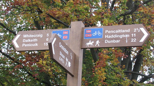
    Just trawling through my Flickr.


    Pencaitland Path sign

    Whatever the surface you won't get lost,

    Posted 10 years ago #
  25. chdot
    Admin

    And now a Flickr group -

    https://www.flickr.com/groups/pencaitland_railway_path

    Posted 10 years ago #
  26. SRD
    Moderator

  27. Schemieradge
    Member

    East Lothian Paths Feasibility Study March 2014 Summary Report Extract:


    Background and Existing Condition:
    The Pencaitland Railway Path is 10.2km long. The western part of the railway to #Ormiston was part of a branch line constructed in 1867 by the North British Railway Company. Although primarily a mineral line, it also took passenger trains from Edinburgh to Macmerry. The section of line from Ormiston to West Saltoun was part of the Gifford and Garvald light railway that opened in 1901. The remaining section of line closed in May 1965 and the majority of the route was purchased by East Lothian District Council during the 1970’s.

    The route is now a 2.5m to 4m wide mainly whin dust surfaced path on a combination of embankments and cuttings. There are a number of wet and muddy sections and an obvious drainage problem at the western end of the path near Crossgatehall. The remainder of the path is comparatively drier although the trend towards a warmer and wetter climate has resulted in a soft surface and evidence of damage to the surface as a result. There are a number of access points on to the path, both formal and informal. Car parks exist at Saltoun Station, Wester Pencaitland, Ormiston and Crossgatehall. Signage is poor to and at the main access points and significant improvements could be made to encourage more people to use the route. In particular, the signage to the car parks is poor and several of the respondents stated that they only found the route by accident.

    The railway path is a Core Path and forms part of National Route 196 (Haddington to Penicuik).

    Landownership:
    The majority of the railway path is owned by East Lothian Council. The western end of the route near Crossgatehall is in private ownership and is leased to the Council. An approach was made to the landowner for comment on any proposals and the response is attached as an Annex to the main report.

    Existing uses:
    The path is currently used by walkers, runners, cyclists and horse riders. Whilst many are happy with the current surface, there are a number of respondents who have stated that they would use the route more if the surface was drier and firmer. Others have commented that the wet sections of path make walking with children or cycling difficult, especially through the winter months. Horse riders generally have commented that they like the current surface.

    Route options:
    The brief for the study asked the consultant to consider surfacing options and “to assess the feasibility of resurfacing the railway paths to enhance visitor experience and encourage new users”. However, surfacing options cannot be seen in isolation and many of the comments from those who responded to the consultation stated that signage to the railway paths, signage to facilities from the railway paths and access points could be improved as a means of encouraging wider use. Improvements to access points could include removing steps and replacing with a ramp as appropriate, formalising desire lines and introducing entrance features. This work is outwith the remit of this study and should be considered separately. In addition, an interpretive plan should be undertaken for the railway paths in order to engage with the users (especially children) and encourage repeat visits.

    The studies detailed above in paragraph 5 have shown that providing good quality facilities for walkers and cyclists increases usage and this will be taken into account in the following path options appraisal.

    The following 3 options will be considered in order to enhance the visitor experience and encourage new users:

    1. Leave the current surface, improve access points, improve signage;
    2. Resurface with a semi-bound surface eg Toptrec , improve access points, improve signage;
    3. Resurface with a sealed material eg Bitmac (DBM), improve access points, improve signage.

    The route is currently between 2.5m and 4m along the full length, with the majority of the route being of the narrower width as this was a single track line. Any surfacing of the route would therefore have to accommodate all users as there is not enough width to have a segregated route. The vegetation at the sides of the track is already cut back to give a wide and high useable corridor and this does increase the useable width.

    Conclusions:
    There are a number of options available for the Pencaitland Railway Path from maintaining the status quo, to a full resurface of the path. Of the 97 responses to the consultation, the majority were about the railway paths and these should therefore be taken into account in any decision. Many of the cyclists and walkers who responded requested a firmer and drier surface although others stated that it was fine for recreational use. Horse riders do not wish a hard or sealed surface and others commented that this would be “urbanising” the countryside. A good compromise that would suit all users is therefore Toptrec. This is a recycled material that looks similar to the existing surface, but as it has a degree of asphalt material, it forms a drier and hence firmer surface than then existing whin dust. Midlothian Council has recently laid Toptrec on a similar path and it has been well received by all users. It is therefore recommended that the Pencaitland Railway Path is resurfaced with Toptrec but with additional work being carried out to access points and a comprehensive signing and interpretive programme to encourage wider use.

    Posted 10 years ago #

RSS feed for this topic

Reply

You must log in to post.


Video embedded using Easy Video Embed plugin