CityCyclingEdinburgh Forum » Infrastructure

pentlands path advice

(60 posts)

No tags yet.


  1. algo
    Member

    Hello,

    I am planning a route for the weekend and shamefully have never actually tried this - I was wondering if someone knew how possible it was to pass on a commuter-type bike (specifically my trusty old courier race with 28 continental touring plus tyres) - will it be totally impassable at the moment or will it just be a bit uncomfortable for a bit?

    Any advice as always much appreciated

    Posted 10 years ago #
  2. Radgeworks
    Member

    Hey Algo, i am doing something very very similar about 2 miles west of there myself this weekend, as ive done your route previously, i would venture that conditions are quite sticky mudwise usually this time of year, so think tyres,as you will need to be careful about loose rocks and wee landslips too, sometimes the path gets covered up, other times it turns into a wee stream, or just vanishes due to erosion.
    Care will get you there (and back hopefully!).
    Good luck and enjoy the wildlife and great scenery. Radgeworks

    Posted 10 years ago #
  3. algo
    Member

    Hi Radgeworks - thanks a lot for the advice. I may have to be prepared to walk some bits of by the sounds of it! I won't be able to get more appropriate tyres by then - mine are continental touring plus, and I think my friend has continental sport contact. I don't mind walking or carrying for bits of it, but hopefully not the whole lot!

    Weather's supposed to be ok for Sunday - hope you have a great ride too - I'd be interested to know your route! We're carrying on to Penicuik and then the path past Rosewell to Dalkeith and then Musselburgh before heading back to town.

    Posted 10 years ago #
  4. cb
    Member

    I imagine it would be easier going west to east as the ascent is less steep.
    Never riden it, but it's much better than the path over from Bonaly unless that's been upgraded recently (I tend to stick to tops and ridges when hill walking).

    Some pics from Geograph might give you an idea but probably worth noting when they were taken (both the year and the time of year).

    Bikes in two of them, one of them looks like a tourer!

    http://www.geograph.org.uk/photo/463757

    http://www.geograph.org.uk/photo/669470

    http://www.geograph.org.uk/photo/29513

    http://www.geograph.org.uk/photo/669515

    http://www.geograph.org.uk/photo/2650582

    Posted 10 years ago #
  5. Morningsider
    Member

    Could be pretty muddy - have you thought about going via Balerno, cross the bridge over Threipmur Reservoir, past Loganlee Reservoir and down to Glencorse. A good bit of this is on tarmac or fairly decent path - should all be passable on your bike and is a really nice run. There is a very steep hill on the way up to Loganlee, but should be cyclable in first or second gear.

    Posted 10 years ago #
  6. EddieD
    Member

    I've done that route with 28 Marathons, and it's doable, but on the Glencorse side, certainly lower down, the path is a bit iffy, and you'll probably need to push a little. On the Harlaw side the path is fine. It'll probably be a bit muddy on the Glencorse side, but the Harlaw side should be fine - the path got made up a few years back and it tends to be okay.

    Posted 10 years ago #
  7. algo
    Member

    @cb - thanks a lot for the links to the pics that helps a lot. Seems like after all the rain it may be pretty muddy!

    @morningsider - thanks a lot for the route info - if that's all pretty decent path I reckon we'll do that then. I don't mind admitting I get off occasionally for very steep hills :-)

    Posted 10 years ago #
  8. algo
    Member

    EddieD - thanks (sorry replied before saw your message) - still an option then! Thanks a lot for all the helpful responses...

    Posted 10 years ago #
  9. DaveC
    Member

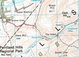
    Have you considered the route across further up? Brave Law to The Howe.

    I've ridden this but only in summer. I imagine the worst ground will be the section from Bravelaw Castle to the Bealach (saddle) between Hare Law and Black Hill. There is a small burn which will could be boggy, but from the bealach to the farm near the reservour it was stoney last time I rode along it.

    Its less of a climb on boggy ground, as the tarmac goes to Brave Law, and there is more tarmac from The Howe.

    I have cyclocross tyres you could borrow, but I live in Dalgety Bay so can't get them to you today.

    Posted 10 years ago #
  10. algo
    Member

    Hi Dave,

    I think that's what Morningsider is suggesting - I reckon we will have a go at that. Thanks loads for the offer of cyclocross tyres - given my friend has road tyres, and a lot of the rest of the route is (theoretically) on tarmac, I reckon I'll just carry the bike over the worst bits of mud... very kind of you to offer though (as always).

    Posted 10 years ago #
  11. AKen
    Member

    I've done this stretch many times on a courier with 26" wheels and semi-slick tyres. It's do-able, but - after all the rain we've had - will be muddy in bits and some parts are likely to be flowing streams.

    From Harlaw up to the gate at the highest part of the route, the path is very good but interrupted by planks that divert water off the path. After the gate, it is very stony until almost down at Glencorse where it is likely to be muddiest. It's this half where you'll probably encounter flowing water. Pick your route carefully round the stones and you'll be fine (if perhaps a little muddy).

    I like to combine this in a loop with the route described by DaveC and Morningsider via Bavelaw Castle and usually go uphill from Glencorse then downhill towards Harlaw. Going the other way, it's a bit too bumpy to go downhill at any speed on a non-MTB.

    Posted 10 years ago #
  12. algo
    Member

    thanks AKen - another well-informed vote for muddy... I think we'll go the way DaveC and Morningsider suggested and we'll get to see what it looks like at the Glencorse side so I'll try and remember to take pictures if we do go.

    Posted 10 years ago #
  13. AKen
    Member

    Enjoy the climb up to Bavelaw Castle! (Incidentally, the highest house in Edinburgh. And it really feels like it.)

    Posted 10 years ago #
  14. cb
    Member

    "Incidentally, the highest house in Edinburgh"

    Hey, great bit of trivia AKen. At 320m it's 70m higher than the summit of Arthur's Seat.

    Not the highest house in the Pentlands though, there are a few farms on the south side tickling the 350m contour.

    Posted 10 years ago #
  15. Roibeard
    Member

    I did this last January, but went up more from Harlaw - that was really very wide steps with railway sleepers retaining the path.

    The descent was very eroded and stoney/bouldery, with deep gullies - I decided not to ride the commuter(28mm Marathons) down some of the drops, and still got a pinch puncture (in a hailstorm). At the east end, the path was steepest and most eroded.

    I'd have said full suspension was a better option that day.

    Bear in mind though, that this is 12 months ago, and the path may well have been fixed/upgraded since.

    Robert

    Posted 10 years ago #
  16. I were right about that saddle
    Member

    The path on the Glencorse side of Green Cleugh was bulldozered in October. There's loose hardcore that's difficult to cycle on, but that would be the case with any kind of tyre.

    The loop from town up the WoL, over Green Cleuch and down the Esk to Musselburgh path and back up the Innocent Railway is a nice day out...

    Posted 10 years ago #
  17. algo
    Member

    IWROTS - thanks. That's pretty much what we're doing but without the WoL as it's apparently really muddy at the moment. How much of the path is just hardcore do you reckon? I've walked it in the past but quite a while ago....

    @Roibeard - thanks for the input. Sorry not sure what you mean by "went up more from Harlaw" - are you talking about the image I posted, or the route Morningsider suggested?

    Posted 10 years ago #
  18. algo
    Member

    double post - apologies

    Posted 10 years ago #
  19. Roibeard
    Member

    @algo - We went from Harlaw reservoir up to the saddle and down to point A on your picture, we didn't start at point B.

    I've done Morningsider's route in reverse = Flotterstone->Loganlea->Threpmuir (to Harlaw, rather than direct to Balerno) over the Christmas break and it was much more reasonable even on touring bikes.

    There is one point, however where the path has been washed away and the bikes needed to be carried around a spur of the hill, then over a stream on stepping stones, rather than riding alongside the stream to the stepping stones - easily enough done if you're fit, but folk need to be able to carry their bike on quite a steep section of scree/hill (or get someone else to carry the bike!).

    Robert

    Posted 10 years ago #
  20. algo
    Member

    @Roibeard - perfect, thanks a lot for clarifying. Will have a go and try and post some pictures up all being well.

    Posted 10 years ago #
  21. cb
    Member

    "There is one point, however where the path has been washed away and the bikes needed to be carried around a spur of the hill"

    I think from that descripion you must have been on the wrong side of the burn. I might be wrong, but I think when heading west from The Howe it feels more obvious to stick to the north side, but you should actually cross over the burn (using The Howe's access bridge?) and continue on the path on the south side of the burn.

    This bit was grassy and slidey on slickish 32 tyres when I went that way a few years back. Further up there is a newish bridge to take you back to the north side.

    I might have completely misunderstood you, Roibeard, in which case apologies.

    Anyway it sounds like, from IWRATS's post that this section of path is under the process of being improved?

    Posted 10 years ago #
  22. Roibeard
    Member

    @cb - from Flotterstone there are multiple crossings of the burn, two have bridges before you get to the third (where two tributaries join). This last was a ford in January 2013, but was a bit deep this year, and just prior to it, the stream had completely removed the path.

    It's just at this point, before the waterfalls (heading west).

    Robert

    Posted 10 years ago #
  23. cb
    Member

    @Roibeard, ah got you, I had thought you were referring to the bit a little down stream.

    It must be three or four years since I went through there (in the summer I think) and I was able to cycle all the way (just). Def. trickiest around about your Google link though.

    Posted 10 years ago #
  24. allebong
    Member

    +1 to avoid the original route, it's not even that much fun at this time of year on a mtb, anything less would really struggle on a lot of it and likely sap the enjoyment out of it.

    +2 for the alternative route, it's much more pleasant and manageable.

    I was along the Colinton end of the WoL today on foot and it's actually not that bad. Still a bit mulchy and damp but the really bad slop and puddles have gone. Not sure what it's like further up.

    Posted 10 years ago #
  25. Charterhall
    Member

    The descent down to Glencorse was an absolute quaqmire two weeks ago, barely rideable on an mtb never mind a tourer. And as noted above, the alternative route through Green Cleuch has been washed away, when I did it a few weeks ago it involved an 'interesting' crossing of the burn.

    Posted 10 years ago #
  26. gembo
    Member

    I walked a lot of the discussed routes a couple of weeks back. I recommend what it looks like u are going for. - the Tarmac road from glencorse to loganlea. When it ends you might still be able to cycle the hybrid, and easily push it until it pans out a bit then up to Bavelaw Castle and down beautiful beech avenue to the reservoir of thriepmuir. Easy road down to Balerno either steep by going straight or if take right turn more gradual. ALas, I will be far to the west in Ayr or a cup of tea would be available .

    Posted 10 years ago #
  27. algo
    Member

    thanks all for the advice and offers of tea! Will try and document the extent of the erosion...

    Posted 10 years ago #
  28. algo
    Member

    Thanks to everyone for advice - all completely spot on. Sunday started off beautifully - this is just after Balerno at around 9:45:

    path started off great - really decent surface:

    Then we hit the hardcore that IWROTS mentioned on the downhill section:

    This is probably the worst surface to cycle on as the covering of loose stones is quite thick. Then we reached the bit that Roibeard mentioned:

    and from the other side:

    seems like the erosion is caused by the burn occupying where the path used to be.

    We managed to cycle all of the rest of path, and there are options at that crossing as it might be possible to cross to the other side, and the burn is quite shallow at that point. Over the grassy sections it's a bit muddy but completely fine on my 28 contintentals. Went on to Penicuik and through Dalkeith to Musselburgh and back to town - horrendous hail later on but at least the wind was behind us at that point!

    Thanks again to all for the advice on the path choice.

    Posted 10 years ago #
  29. gembo
    Member

    @algo, if walking you can use the other side but cycling either carry or cycle through the burn

    I marshalled the summer solstice triathlon one year in a downpour of monumental proportions. Frogs abandoned me at the loganlea gate so it came as. Bit of a surprise whenthe competitors arrived on the hillside cycling through the burn I would have thought far side.

    Posted 10 years ago #
  30. HankChief
    Member

    Out of interest. Is there a cycle route from the Balerno side to Nine Mile Burn?

    Looking for the easiest route and whether it would be suitable for the Cheiflets.

    Posted 4 years ago #

RSS feed for this topic

Reply »

You must log in to post.


Video embedded using Easy Video Embed plugin