CityCyclingEdinburgh Forum » Infrastructure

New Cycle Route Signs

(179 posts)
  • Started 10 years ago by HankChief
  • Latest reply from wingpig

  1. HankChief
    Member

    Good news...

    The new metal posts that have been springing up around West of Edinburgh now have signs on them.


    Pinkhill Railway sign by HankChief, on Flickr

    Looks like they are part of a netw**k given that they are numbered - with route 9 being City Centre to the Gyle.

    Which is good given the difficulties which used to exist to explain the route to others

    Anyone spot any other signed routes?

    And just for a bit of fun, lets play spot the difference between the near and far signs in these photos at Dovecot Road in Corstorphine...


    Dovecot Road - Facing South by HankChief, on Flickr


    Dovecot Road - Facing North by HankChief, on Flickr

    Posted 10 years ago #
  2. gembo
    Member

    Jenners suppository, up to Stenhouse path with spur to Balgreen, including golf course. So all these spots somewhat localised.

    Posted 10 years ago #
  3. Morningsider
    Member

    All part of the (very slow) roll-out of the family network of routes set out in the Council's Active Travel Action Plan (published 2010).

    Posted 10 years ago #
  4. crowriver
    Member

    Porty-Leith has route '10' signs along it.

    Posted 10 years ago #
  5. Focus
    Member

    Maybe they'll eventually get round to signposting the way onto the NEPN at Craigleith Crescent from Queensferry Road after all these years. Its been a bizarre omission for too long.

    Posted 10 years ago #
  6. HankChief
    Member

    My sense of humour must be too subtle...

    All four direction signs at the Dovecot Road junction shown above (2 pointing West and 2 pointing East) are identical and say they point to the city centre.

    Made me chuckle.... (And report to Clarence)

    Posted 10 years ago #
  7. wee folding bike
    Member

    There is at least one sign on Bute which says Rothesay in both directions. Of course it is correct.

    Posted 10 years ago #
  8. SRD
    Moderator

    Hankchief - I was confused. Are you saying these are NEW signs and they are incorrectly pointed? Or is it just the usual issues of 'yoofs' moving them? (Another reason I don't care for signs)

    Posted 10 years ago #
  9. Simon Parker
    Member

    The top tip for cycling safely in Amsterdam is Know where to ride. The second tip is See the signs. The last tip cautions that "winging it" without a route plan can be inefficient and dangerous.

    The opening paragraph of the Executive Summary to a policy document produced for the European Parliament entitled The Promotion of Cycling says:

    Mobility may be regarded as the ability to travel, although its meaning could be much broader, since mobility encompasses not only the activity of travel, but also, more importantly, the possibility for the traveller to decide when and where to travel, by being aware of, and being able to make use of, an information set for optimising the journey.

    The same paragraph is repeated word-for-word in the Introduction.

    However, it must be said that direction signs and not much else represent a very poor effort on behalf of the authorities.

    Furthermore, I believe that repeat markers on the road surface offer a much better "stepping-stone" solution than signs on poles. They are less likely to be vandalised; they are less likely to be covered by vegetation in the summer, or blown about by the wind in the winter; they would better help to reduce street-clutter; they would better help to raise the awareness of motorists; and they would better help cyclists to ensure that they position themselves correctly in the road relative to the other traffic (at a right-turn, for example).

    To be clear, they are a vehicular cycling solution, and maintaining this state of affairs is not part of the long-term plan. But with that caveat, I would be interested to learn what people think.

    Posted 10 years ago #
  10. Snowy
    Member

    Incorrect destinations on the signs...the 2 signs pointing west should be stating 'Gyle', etc. But all 4 of these are exactly the same...reminds me of the signpost in Alice In Wonderland!

    Posted 10 years ago #
  11. gembo
    Member

    The two signs pointing west just need to be twisted around the pole 180degrees and then they will be right

    Posted 10 years ago #
  12. chdot
    Admin

    Is Route 9 the same as this?

    http://connectingedinburgh.files.wordpress.com/2013/04/epark.pdf

    Posted 10 years ago #
  13. Morningsider
    Member

    Simon - I was going to explain why using "repeat markers" is very difficult due to the requirements of the Traffic Signs Regulations and General Direction and the Traffic Signs Manual and goes against current thinking in traffic management/streetscape design. But then I thought...why bother!

    Posted 10 years ago #
  14. Focus
    Member

    Painting directions on the road without the backup of signs on poles isn't going to be much use when the on-road markings are covered by motor vehicles. Or worn out, as with cycle lane markings.

    Posted 10 years ago #
  15. Kenny
    Member

    I think I saw a guy attaching these signs on the airport road, at the junction of Gogarstone Road, on my way home from the airport yesterday. The guy had decided to part his van on the path, entirely blocking it, while he was doing his work, and a cyclist with a Karrimor hat on was heading in his direction, about to be forced on to the A8 as a consequence of said parking :(

    Posted 10 years ago #
  16. HankChief
    Member

    It was the fact that whoever put up the signs didn't spot that all 4 were identical that surprised me...

    Anyway, I've done a slightly longer tour of the new signs. The new signs start at the West end of Roseburn Park (you are left with the old signs to get into the city centre / onto the Roseburn path) and then are pretty comprehensive all the way through to Gylemuir (I didn't check the rest of the way to the Gyle).

    As you get further west you start to get signs for the Airport and Broxburn which shows they are thinking of linking to the longer routes.

    A couple of specifics that I didn't like though were:

    The route it takes through Gyle park is different to the one I would take - It goes to the South of the David Lloyd club, whereas I usual go to the North as it is more direct.

    On South side of the Glasgow Road (by the Jaguar garage) the route needs to go along the pavement for 20yds and the sign says "Dismount and use crossing". I don't know why is - the crossing is a toucan (the only one across the A8 in Edinburgh!). I can only assume the pavement is shared use - but then where are you meant to go from the toucan crossing?

    At the junction of Dechmont Road and North Gyle Terrace, their is only a very small arrow with a number 9 on it. This feels inadequate as the rest of the route has big blue signs and from both direction their is a straight on route which you could take if you don't spot it.

    Apart from those (and the 4 identical signs mentioned earlier) it is a good attempt

    Posted 10 years ago #
  17. kaputnik
    Moderator

    Route 6 is I think the QBC "alternative quiet route avoiding the QBC" route.

    Posted 10 years ago #
  18. Simon Parker
    Member

    So it seems that there are gender differences when it comes to navigation strategies. Men tend to rely on a sense of direction, while women tend to use landmarks. One explanation is that this is a throwback to our hunter-gatherer heritage, where of course the men would typically venture further away from the village than the women.

    According to a recent study [pdf]

    Male and female subjects were given the task of navigating through an unknown virtual 3D environment and the resulting brain activity was captured with fMRI scanning. While there was a lot of overlap in the activated parts of the brain, a differential analysis showed a significant variation in brain activity between men and women. Women showed greater activity in the left and right pre-frontal regions, while men showed increased levels of activity in the hippocampus.

    (The hippocampus is a key component of the limbic structures of the brain, the older (in evolutionary terms) part of our unconscious mind.)

    This study has interesting implications. For women, navigation is an intellectual task, just like any other, and because it’s being processed at that level, it’s rational for women to ask for help if they are lost.

    For a woman, asking for directions is not an admission of defeat. But for a man, the ability to navigate one's way around operates at an unconscious level. It’s part of who we are, and so it’s subject to irrational behaviours and emotions.

    (This probably explains why men are reluctant to ask for directions. And then when we do ask for directions, what happens? You hear the first couple of instructions, if you're lucky, and then the rest is just white noise. Please tell me that this isn't just me.)

    It is important to note that women do indeed have a sense of direction. However,

    In tests of ability to navigate virtual 3D environments (mazes), there wasn’t a significant difference between men and women in success levels as long as the landmarks were left in place. When these were removed, men showed an ability to keep their bearings and had a significantly higher degree of success (Sandstrom, Kaufman, & Huettel, 1998).

    Make of this what you will, but given that it's unlikely for landmarks to be removed in the real world, the whole thing seems somewhat academic to me.

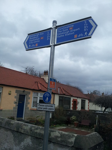
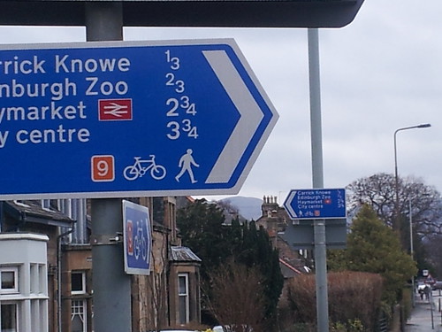
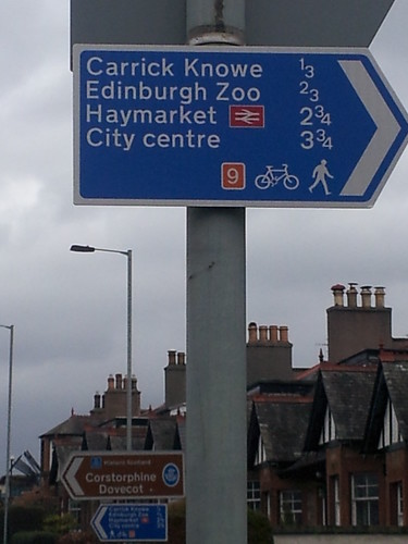
    I have already suggested that people need to know how to get around on the network, but I want to know how useful these direction signs are.

    Just for example, say we're at Dovecot Road. Firstly, do we really need to be told that Carrick Knowe is 500m away? Is this useful information? And what does it mean? The shops are 500m away? Where are the shops?

    Secondly, what are the chances that we will be visiting the zoo today? How often do you go to the zoo? If you don't know where it is, what are you doing on Dovecot Road? Are you lost? If you don't know where it is, why have you not planned your route before setting out?

    If you need to plan a route - if you need to refer to a map - the diagrammatic Tube-style map is in fact easier to read, mainly because colour-coding makes route-planning easier.

    I tested the London map using the origin and destination examples of a thousand bus journeys. If a bus went from A to B to C to D, I looked at the journeys A to B, A to C, A to D, B to C, B to D and C to D. I found that about 90% of the time, the journey could be described by one, two or three routes. (I think the average was about 2.4 routes per journey.)

    So you would plan your route before setting off, and then the chances are that you would need to remember just a couple of pieces of route information. And if you forget whether it is R2 or R3 or whatever, the map is small enough to fit into your back pocket.

    Now, Focus's point about the need for direction signs at strategic locations (as a sort of back-up) is entirely correct, but as I pointed out in the cycle network thread, do these signs need to be aimed specifically at cyclists, or can they just be general information signs aimed at a general audience? Just asking ...

    Posted 10 years ago #
  19. wingpig
    Member

    "(This probably explains why men are reluctant to ask for directions. And then when we do ask for directions, what happens? You hear the first couple of instructions, if you're lucky, and then the rest is just white noise. Please tell me that this isn't just me.)"

    Unfortunately I cannot personally corroborate your experience.

    Posted 10 years ago #
  20. wingpig
    Member

    "...given that it's unlikely for landmarks to be removed in the real world..."

    You seem to be familiar with London. Some bits of London have lots of tall buildings, some of which may well be distinctive or recognisable whilst others may appear similar to each other. Whilst London has a number of tall landmarks which even people who don't have to live there on a daily basis might recognise and be able to use for navigational purposes, it only takes a few very tall but unrecognisable buildings close by for recognisable landmarks slightly further away to be obscured. The landmarks have not been removed, but may become temporarily absent from the visual field.

    Posted 10 years ago #
  21. Baldcyclist
    Member

    I like signs. Directional signs let you know where to go if you have never been to a place before, good.

    Cycle specific signs let other infrastructure users (who may also not be frequent users of said infrastructure, especially if shared) know there is likely to be bikes about.

    They shouldn't be on every second lamp post, just where necessary.

    That thing about signs being a 'drivers thing', I read somewhere (can't quote the specific passage off the top of my head ;) ) that "70% of all adult cyclists are also drivers". Also if you are trying to get drivers out of their cars and onto bikes, then it makes sense for the signs to be in a 'language' they already understand. In-fact to analogise, why would you have French signs for pedestrians, and Italian signs for cyclists, and German signs for drivers. Why not just have English signs for everybody? That way, whether on foot, bicycle, or in car the signage displayed is understandable to all.

    Posted 10 years ago #
  22. Simon Parker
    Member

    P.S. The map of the proposed Edinburgh Cycling Network has generated 3000 views in less than two-and-a-half weeks. I am so totally blown away - very humbled, indeed - that that so many people have taken an interest in this work.

    Posted 10 years ago #
  23. wingpig
    Member

    I've been to the zoo perhaps ten times in twenty years, so I could say I go to the zoo once every two years. I definitely know where it is as I've been past or near it many more times than my ten visits would suggest. Tomorrow I shall celebrate by visiting Dovecote Road and wandering freely along it.

    Posted 10 years ago #
  24. chdot
    Admin

  25. HankChief
    Member

    @chdot - in that screen shot it talks about putting in toucan crossings for both Saughtonhall Road and Balgreen Road. Which would be great but hasn't happened (yet).

    It also says Carry on into Edinburgh Park - possibly the prettiest business park in Britain which wouldn't be my view on it...

    In other news, I've spotted another incorrect sign. On the South side of the RBS bridge the signs are pointing North & East when they should be West & North.

    Posted 10 years ago #
  26. chdot
    Admin

    "Which would be great but hasn't happened (yet)."

    Well that was the plan!!

    "which wouldn't be my view on it..."

    At the time quite a lot of effort had gone into visual aspects of EP - the Loch, the Herms etc.

    I wouldn't write that now.

    Posted 10 years ago #
  27. ARobComp
    Member

    IT's quite interesting to read about how people navigate. I have a tendancy to just aim for the biggest longest road that's roughly in the right direction and just head that way until I hit it! Tends to work for navigation in new cities. Sort of works in Edinburgh so long as you don't overshoot!

    Posted 10 years ago #
  28. chdot
    Admin

    "IT's quite interesting to read about how people navigate."

    I have a very comprehensive 'map' in my head of Edinburgh's off-road routes having ridden them 'all' many times.

    Of course this was helped by studying the Spokes map.

    When OSM/CycleStreets came along I 'discovered' cut-throughs I didn't know about - the benefits of really 'local knowledge'.

    I know some bits of London quite well, but, now, generally rely on 'electronic help'.

    Posted 10 years ago #
  29. cb
    Member

    It's surprising how many little cut-through paths are not on OSM. I have added quite a lot over the last year or so. E.g. between Riselaw Terrace and Riselaw Place (not that you'd want to use that on a bike although I did carry a buggy down the steps).

    There are lots of cul-de-sacs which are only dead ends for motor traffic.

    Posted 10 years ago #
  30. chdot
    Admin

    "not that you'd want to use that on a bike although I did carry a buggy down the steps"

    A lot of OSM mappers are cyclists which perhaps means that routes aren't noticed and/or added.

    Posted 10 years ago #

RSS feed for this topic

Reply »

You must log in to post.


Video embedded using Easy Video Embed plugin