CityCyclingEdinburgh Forum » Infrastructure

No cycling signs - Dalry colonies

(32 posts)

No tags yet.


  1. neddie
    Member

    Does anyone know why these 2 'no cycling' signs are here on the link between Dalry Pl & Morrison Cres.?

    They surely have no legal basis, as the path is not adjacent to any road. They also seem fairly new. Who put them up? Developer? Residents Assoc.? Council?

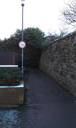
    IMAG0596 by edd1e_h, on Flickr

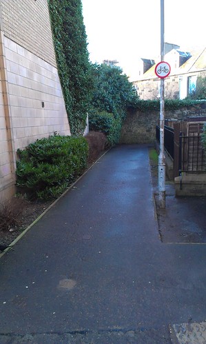
    IMAG0595 by edd1e_h, on Flickr

    Here:
    https://www.google.co.uk/maps/@55.9444281,-3.2151771,19z

    Posted 9 years ago #
  2. Fountainbridge
    Member

    The signs look home made (wrong size, too detaild). Also guessing the land is "private".

    I think there's an old folk home on that corner so probably complaints from residents about being nocked down on blind bends etc

    Some of that development is/was Malcolm Housing Association.

    Council wouldn't put up signs like that as they cost too much money.

    Posted 9 years ago #
  3. gembo
    Member

    That is a nice wee cut through I take when cycling from Fountainbridge to Gorgie dalry. My barber, sweary jim is at the bottom. Those signs just need a wee smile on them to indicate that Gorgie Dalry and fountainbridge welcome careful cyclists.

    Posted 9 years ago #
  4. UtrechtCyclist
    Member

    Yes these have gone up recently.

    This is on a relatively direct, quiet link from Haymarket to the Canal which is used by a lot of pedestrians and cyclists, and really needs improving/protecting.

    I have some sympathy for whoever put up the signs, it's a sharp corner with no visibility around it and whenever I go through on my bike pedestrians get terrified and jump out of my way even though I'm only going at 5mph and am perfectly happy to sit behind them. It's clearly not ideal as shared space. But there doesn't seem to be a good alternative to this path, going the long way around the old people's home takes you to a place where the path is blocked by parked cars.

    Will the new development by Haymarket will include a nice route through for bikes?

    Posted 9 years ago #
  5. slowcoach
    Member

    cyclestreets.net says "Short un-named link:
    Cycling in this section is not permitted", but it also says same for Dalry Place, which has/had "no motor vehicles" signs, rather than "no cycling" signs.

    Posted 9 years ago #
  6. neddie
    Member

    @Fountainbridge

    I don't think the signs are homemade. They look professional, with 'corner cube' type reflective surfaces.

    Posted 9 years ago #
  7. kaputnik
    Moderator

    A bad solution to an needlessly bad bit of path building.

    Posted 9 years ago #
  8. dougal
    Member

    As you go up the incline of the colonies you can turn left and take a slightly (few tens of metres) longer route round to the same place, which I find preferable because there's no sharp & blind angle.

    Posted 9 years ago #
  9. chdot
    Admin

    @ dougal

    Yes, definitely preferable.

    There are times when vehicles parked by the bollards.

    So signs from the WAR crossing, yellow lines etc. would be useful!

    Posted 9 years ago #
  10. chdot
    Admin

    "cyclestreets.net says "Short un-named link:
    Cycling in this section is not permitted" "

    That's not CS as such - data comes from OpenStreetMap - that's due to whoever last changed the tags from cycle=yes.

    IF 'proper' signs, I'm surprised that they are legal - because of access legislation.

    Posted 9 years ago #
  11. chrisfl
    Member

    History of that section in OpenStreetMap is interesting to me anyway, I originally mapped it as foot only (In January 2007! tagging was a lot simpler back then), the bicycle=yes tag was only added 2 years ago.

    Posted 9 years ago #
  12. dougal
    Member

    Absolutely agree on cars parked in the way, but just mentioning in case it wasn't obvious. I only discovered that both left and right ended up at the same place last week, after using it twice-weekly for several months...

    Posted 9 years ago #
  13. cc
    Member

    @dougal - many thanks! That wee cut through was on my only known safe-ish route from the southside to the northern path network, so I was worried when I saw the (pictures of the) signs. But if you can go the other way round to the Colonies, great. Route saved.

    Posted 9 years ago #
  14. A path doesn't need to be beside a road to be a footpath on which cycling is not permitted (it was a misconception I was under for a long time, I believe Morningsider put me right) so it may be perfectly 'lawful' signage.

    One thing I would say is that if I knew I was regularly 'terrifying' pedestrians, I'm not sure I'd be cycling through there. And certainly if I'm cycling at 5mph I might as well be walking at 4mph. How long is the section? 20m? Cycling saves roughly 4 seconds? Difficult to see how the 90 degree blind corner could be engineered out, given it's between buildings and gardens and walls.

    Posted 9 years ago #
  15. Dave
    Member

    Council's record on signage is so bad as to make everything hardly worthy of notice IMO. After all, it only took them a decade to bring some of their most prominent signage in line with the LRA.

    It's not hard to believe that if the right sort of person is involved they'd find it easy enough to get some legally meaningless but shiny metalwork stuck up. We're not exactly short of examples, are we?

    Posted 9 years ago #
  16. gembo
    Member

    Gone through it many times, never terrified anyone. Rarely met anyone. Is hard to go at much speed due to ninety degree turn and wall. Anyone going above 5mph should go home and reconsider their lives as obi wan suggests

    Posted 9 years ago #
  17. Arellcat
    Moderator

    I used the little path the first few times after I'd discovered the route up from Dalry Road and across the West Approach Road, when the zigzag path was new, but I didn't like the right angled corner despite pinging my bell and shining my headlight.

    I quite quickly realised that you could go around on the road instead, and I've never needed to use the path since.

    Posted 9 years ago #
  18. Fountainbridge
    Member

    As far as I know signs have to be a particular size and design to be legal. The sign seems to be too small though.

    Posted 9 years ago #
  19. HankChief
    Member

    This thread talks about the need for a 'path' to be listed on CEC's list of public roads for them to be able to ban cycling.

    You'll see further down the thread that morningsider links to the list. For my pet project I read through the entire list and couldn't find my 'path' listed so queried it with CEC only to be told that it was omitted from the list and they were in the process of updating it.

    Posted 9 years ago #
  20. neddie
    Member

    Good to know there is an alternative route, if somewhat circuitous.

    Would've been nice if they had signed it in a 'more positive' way.

    Like putting up some nice blue direction signs, directing cyclists around 3 sides of a square, and just not bothering with the red circles.

    @WC

    Difficult to see how the 90 degree blind corner could be engineered out

    It could have easily been engineered out when they built the new flats in the first place. The flats are only 10 - 20 years old. It could have been designed as a full segregated Dutch style bike route. But no, that's 'too challenging', even today :-(

    Posted 9 years ago #
  21. Absolutely agree on that, but there seemed some suggestion upthread that 'something must be done' and sadly planning time machines aren't on the go yet.

    On sign sizes, from the government manual:

    5.26 The sign to diagram 951 is used to give effect to a prohibition of cycling made under an order, or, more often, imposed by a byelaw. It is mainly used where there are pedestrian routes through housing estates which are not suitable for cycling because either their width or the visibility along them is
    not sufficient. In order to make such areas more accessible, local authorities are encouraged to provide suitable facilities for cyclists (see section 17 for the signing of cycle facilities). The sign to diagram 951 should not be used to indicate the end of a shared pedestrian and cycle facility (see para 17.36).

    There's then a no cycling sign with sizes listed. Seems optimum size is 450mm diameter, but can vary from 270mm to 600mm.

    Document here

    EDIT: apologies, I misread the 'something must be done' post the precipitated my comment on 90 degree bends. No-one suggested anything of the sort.

    Posted 9 years ago #
  22. davidsonsdave
    Member

    "CYCLE ROUTE BETWEEN MORRISON CRESCENT AND DALRY ROAD

    Thank you for your email, of 18 February 2015, regarding issues with the above route.

    The ‘no cycling’ signs were erected in response to a number of complaints received from pedestrians who have come into conflict with cyclists at the blind bend on this path. It is not legal for cyclists to use the path and this signage has been used to clarify the situation.

    The route from Dalry Place to Morrison Crescent does form part of our proposed ‘family-friendly’ cycle network and we will therefore investigate measures to improve and sign it. This will include the potential to introduce a prohibition of parking at the bollards on the Dalry Place side. However, it should be noted that the car park on the other side (including the two disable bays) is privately owned and managed. This could potentially limit the scale of the improvements the Council can undertake.

    I hope that you find our response helpful.

    Yours sincerely

    Allan Tinto
    Transport Officer (Cycling)"

    Posted 9 years ago #
  23. neddie
    Member

    It is not legal for cyclists to use the path

    Does that mean the 'path' is now listed on CEC's list of public roads (so that CEC can legally ban cycling on it)?

    Or is this just BS made up by the council...?

    Posted 9 years ago #
  24. Dave
    Member

    It would be useful to go back on that and ask for the enabling legislation. Is there a bylaw?

    Posted 9 years ago #
  25. davidsonsdave
    Member

    Thanks edd1e_h and Dave.

    I do appreciate that the layout of this lane has the potential to lead to conflict between cyclists and pedestrians but it does irk me that this has been addressed by putting up no cycling signs rather than putting up signs directing cyclists around the slightly longer route and making some changes to that longer route so that it cannot be blocked by parked cars.

    In my response to the letter, I have asked for details on the legal basis of the ban.

    Posted 9 years ago #
  26. davidsonsdave
    Member

    "CYCLE ROUTE BETWEEN MORRISON CRESCENT AND DALRY ROAD

    Thank you for your further e-mail, of 4 March 2015, regarding the above route.

    This footpath is adopted under the Roads Scotland Act 1984 and, as per adopted footways associated with a road, cycling is not permitted on it. In order for cycling to be permitted the Council would need to promote a redetermination order to effect a legal change. However, given the relatively narrow width of the path and poor sight lines at the corner we do not consider that this would be appropriate.

    The Council has policies that aim to ensure that new developments have good permeability for walking and cycling and an alternative route for cyclists is available via Morrison Crescent. However, we accept that the connection between Dalry Place and the private car park should have been better designed to avoid it being blocked by parked vehicles.

    As mentioned in my previous letter we will investigate measures that are within our remit/control to improve the situation.

    I hope that you find our response helpful.

    Yours sincerely
    Transport Officer
    (Strategic Planning)"

    Posted 9 years ago #
  27. davidsonsdave
    Member

    I can't find this path on the CEC list of adopted roads but there is a mention of "Carriageways & adjacent footways adopted for maintenance" against Morrison Crescent.

    The path is no narrower than other shared cycle paths, for example, between Haymarket Yards and Balbirnie Place but as I have previously said, there is a potential issue with "poor sight lines at the corner" due to the fence.

    If I wanted to have a fence higher than 1m at the front of my property I would need planning permission as it is next to a carriageway and adjacent footway. The permission would rightly be refused as it would "introduce a harsh form of boundary treatment to the detriment of the otherwise open character and appearance of the street scene". I can't find any planning permission for the existing fence at this location.

    Posted 9 years ago #
  28. dougal
    Member

    It is not legal for cyclists to use the path and this signage has been used to clarify the situation.

    The route from Dalry Place to Morrison Crescent does form part of our proposed ‘family-friendly’ cycle network and we will therefore investigate measures to improve and sign it.

    I think there's some leap of logic I don't fully understand here... where it's considered acceptable to make it illegal to cycle on the "family friendly" cycle network... and to say so without hint of embarrassment.

    Posted 9 years ago #
  29. kaputnik
    Moderator

    Family bike-pushing network

    Posted 9 years ago #
  30. rbrtwtmn
    Member

    With this issue in mind does anyone know if there have been discussions about permeability (by bike/foot) through the new development at the former Morrison Street Goods Yard ( http://osm.org/go/evfLKYHOI--?layers=N&m= ).

    This development seems like an ideal opportunity to bypass the footway/car-park blockage. There's also the possibility that walking could be made easier... given that the supposedly pedestrianised Dalry Place actually gets quite crowded with moving and parked vehicles sometimes... not all of which move at a sensible speed.

    Also - has anyone looked deeper at the statement "This footpath is adopted under the Roads Scotland Act 1984 and, as per adopted footways associated with a road, cycling is not permitted on it." I've tried, and it ends in a bit of a legal tangle between the Roads Act and the Land Reform Act... with definitions of exactly what a road and footway is, and the word "associated" which I couldn't see clarified anywhere really obvious. Strikes me (at least without the in-depth knowledge) that this might be one of those legal grey areas where there isn't actually a really clear rule just now...

    Anyway - one way or another I dream of sailing through the new development and joining Haymarket junction at a new well designed cycle track which allows me to filter across a completely new and re-designed junction... (give it another hundred years and you never know)

    Posted 8 years ago #

RSS feed for this topic

Reply »

You must log in to post.


Video embedded using Easy Video Embed plugin