CityCyclingEdinburgh Forum » Infrastructure

Pentlands to Portobello cycle/walk path?

(114 posts)

No tags yet.


  1. SRD
    Moderator

    "Plans for new cycle path and walkway"

    http://www.edinburghnews.scotsman.com/news/transport/plans-for-new-cycle-path-and-walkway-1-3763056

    The Burdiehouse Burn starts near Swanston at the foot of the Pentlands, runs between Liberton and Gilmerton, passing Edinburgh Royal Infirmary and Niddrie before entering the North Sea at Joppa.

    Posted 8 years ago #
  2. Stickman
    Member

    This sounds a fantastic idea. The WoL path is one of my favourite things about Edinburgh. If this new path actually happens then a whole new part of the city becomes more welcoming and explorable.

    (I don't know the area very well so have no idea if it's feasible or not, but if a bypass can be built round the city then a riverside path should be achievable!)

    Posted 8 years ago #
  3. This would be FAB! (not biased at all that it would run within 5 minutes of my front door...)

    Posted 8 years ago #
  4. chdot
    Admin

    GREAT!!!

    I have a council document from the sixties outlining this route!

    Of course much is already there so it's about improving surfaces (bits in the Burdiehouse Burn Park have recently been tarmacced) adding links and extending towards the Pentlands (there's a bypass in the way!)

    Posted 8 years ago #
  5. twq
    Member

    I would use this several times a month - as long as it is properly built!

    Posted 8 years ago #
  6. Roibeard
    Member

    A fair bit of the path already exists.

    We've used it from Burdiehouse to Gracemount - unfortunately one has to currently climb up to and cross Gilmerton Road rather than cycle under it, but then it is possible to cycle along Ellen's Glen (can be muddy).

    The main missing links would be across Liberton Golf Club, and through Niddrie, but then it's on to the Innocent Railway/Brustane Burn path (already recently surfaced).

    Could be great if they sort the crossings of the radial roads and upgrade the surface in a few places. I suspect it will just be the surfacing that happens, and some signage, though...

    Robert

    Posted 8 years ago #
  7. amir
    Member

    So the Brunstane burn path has been surfaced? Road bikeable?

    Posted 8 years ago #
  8. Roibeard
    Member

    Yes, but then again I cycled on slicks on my commuter/Brompton on it before hand too...

    Robert

    Posted 8 years ago #
  9. Cyclingmollie
    Member

    I was on the Brunstane Burn path last week. It is now tarmac from Brunstane Mill (the end by the sea) up the hill past the entrance to Newhailes and on under the railway to Daiches Braes. Then it is well compacted blaes until just before Brunstane Road South where it is tarmac again. It's do-able on a road bike.

    Posted 8 years ago #
  10. chdot
    Admin

    "Then it is well compacted blaes until just before Brunstane Road South"

    There's also the option of Daiches Brae, but last time I was there there was a section of rough ground from the path.

    Posted 8 years ago #
  11. cb
    Member

    According to the OS, the burn changes name five times: Swanston > Lothian > Burdiehouse > Niddrie > Brunstane.

    The Lothian Burn section appears to cut south of the bypass for a short section. Perhaps we should campaign for the route to follow the burn religiously and get a couple of new underpasses?

    Posted 8 years ago #
  12. chdot
    Admin

    "Perhaps we should campaign for the route to follow the burn religiously and get a couple of new underpasses?"

    Indeed. (Though a bridge is a more 'realistic' option.)

    It IS possible to get under the bypass (with a bike) in one of the culverts. Ages since I did it and didn't follow burn any further through the fields.

    Maybe a CCE recognisance trip sometime?

    Posted 8 years ago #
  13. chdot
    Admin

    "Could be great if they sort the crossings of the radial roads"

    There used to be an underpass at Burdiehouse, but some local youf rolled a large hay bale into one entrance and set fire to it.

    Local non-youf got the underpass shut.

    Posted 8 years ago #
  14. chdot
    Admin

    "The Lothian Burn section appears to cut south of the bypass for a short section."

    Ah yes, I'd forgotten that. Perhaps the intention is to keep to the north side of the bypass and go to the Hare Burn.

    But another crossing of the bypass away from main roads WOULD be useful.

    Posted 8 years ago #
  15. cb
    Member

    "It IS possible to get under the bypass (with a bike) in one of the culverts. Ages since I did it"

    Probably shouldn't be surprised by this.

    Did you need a torch?

    Posted 8 years ago #
  16. chdot
    Admin

    "Did you need a torch?"

    No it's straight through and not that long. Reasonable height - though I can't remember if I could stand up fully.

    BUT (it was some years ago) the burn is fenced and there was a fair amount of bushiness.

    Posted 8 years ago #
  17. urchaidh
    Member

    A decent link between the end of the Brunstane Burn Path and Portobello prom would be great - I often go out that way with the kids to get to Newhailes and beyond, and that section is a real PITA.

    I can't see any reason why the footpath between the end of the prom and Eastfield isn't shared path already. Where the footpath isn't wide enough, the road right along there is a wide four lane road with two lanes permanently used as residential car parking, use some of that.

    Posted 8 years ago #
  18. chdot
    Admin

    @ u

    Indeed

    The path through Joppa is plenty wide enough for shared use.

    The road is even wide enough for a segregated cycle lane or two!

    Posted 8 years ago #
  19. newtoit
    Member

    Done some of this route fairly recently.

    The Joppa end of the Brunstane Burn Path is a bit scary... Coming up the hill and through the gap in the wall to find what feels like a 6 inch wide pavement and no way to cross a busy road. Not exactly family friendly!

    Lovely cycle along that path though.

    The path from Gilmerton to Ellen's Glen would hopefully be tarted up a bit though, it's pretty tough going not to mention the faff of opening the gates at Gilmerton and crossing the road.

    Also, what is the point of the chicaney thing between Gilmerton Morrisons and the Burdiehouse Burn? Seems totally restrictive and would be a massive barrier to the disabled - had to lift my bike over. Would post a picture but don't have one of those new-fangled flickr things :P Sure someone knows what I mean? The diagonal gate things which you can't fit handlebars through?

    Posted 8 years ago #
  20. That being the bit of road that 'used' to be four lanes, with plenty space beside the parked cars to be a pseudo bike lane; then they put hatch markings in the centre, narrowed the lanes, but retained the ability of people to park, meaning bikes have to use the moving traffic lane instead. It was truly one of the least well thought out road changes in the city.

    Posted 8 years ago #
  21. chdot
    Admin

    This is (more or less) the route -

    http://ridewithgps.com/routes/7773179

    There is one point where I don't know if it will be 'possible' to cross a fence and proceed on a fairly short rough section (road alternative available).

    Posted 8 years ago #
  22. chdot
    Admin

  23. chdot
    Admin

    Rideable loop following (parts of) Burdiehouse and Braid Burns -

    http://ridewithgps.com/routes/7860508

    Posted 8 years ago #
  24. chdot
    Admin

    "

    9.2 Pentlands to Portobello Cyclepath and Walkway – Motion by Councillor Robson

    "Committee welcomes the proposal by Friends of Burdiehouse Burn Valley Park to create a joined-up cycle path and walkway from the Pentlands to Portobello drawing inspiration from the Water of Leith Walkway. Discussions on proposals for housing at Moredun and Burdiehouse within the Local Development Plan prompted the Friends Group to look at the opportunity to create new links and public spaces along the burn that runs through the park and on to Portobello.
    Committee notes the positive initial interest in the initiative from local ward councillors, Edinburgh and Lothians Greenspace Trust, Portobello Community Council and Spokes.

    Committee further notes the intention to set up a local working group to bring all interested parties together.

    Committee instructs a report to go to the Transport and Environment Committee to consider the approximate costs and potential sources of funding for such an initiative.”

    "

    http://www.edinburgh.gov.uk/download/meetings/id/47256/full_meeting_papers_-_te_committee_-_020615.

    Posted 8 years ago #
  25. chdot
    Admin

    Potential route under the bypass

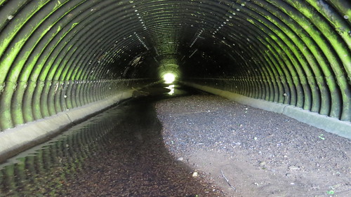
    I don't know what rules there are about routes like this. The headroom is about 6'6" (currently a bit less at the downstream end due to silt).

    Elsewhere it's been suggested that a much smaller culvert is 'ok'. Of course Network Rail is notoriously 'difficult', but this sets a precedent (the Ramblers are disagreeing with NR but I suspect they might be happier with this one if access was improved.) -

    "

    At Ben Lui, where BTP officers have been monitoring the main western ascent/descent route from Glen Lochy we've indicated that we see no problem in crossing the line by this route and consider that the alternative suggested – using a low culvert and wading through the burn which feeds into the main river – is dangerous due to slippery surfaces in the culvert as well as deep water pools. The BTP officers who were on site appeared to accept these difficulties and did not disagree that a better approach would be to continue walking across the railway line but with NR signage in place to warn of the risk from approaching trains.

    We were told by the BTP officer who had tried the culvert route that he had had to remove his rucksack and throw it across the railway line before squeezing through the culvert. In addition to these problems there is also the expectation that anyone using the culvert route is likely to have their boots fill with water, which is not the way that most hillwalkers would expect to start an ascent of Ben Lui in winter.

    "

    http://www.ramblers.org.uk/policy/scotland/crossing-railway-lines-in-scotland/background-to-crossing-railway-lines.aspx

    Posted 8 years ago #
  26. cb
    Member

    Further info and pics of the Ben Lui access culvert.

    http://media.sepa.org.uk/media-releases/2014/river-flumes-provide-safe-crossing-for-walkers/

    Big issue for walkers is not the railway but the adjacent River Lochy which needs to be crossed.

    Posted 8 years ago #
  27. chdot
    Admin

    @cb

    Thanks for link -

    "

    “People will have to ford the River Lochy, and may still have to wade at the walkway if river levels are high. They do also have to stoop when going under the low railway bridge but, with a little care, the Eas Daimh walkway adds interest to the route while keeping walkers out of danger from the railway.”

    "

    That's from a SEPA person, so this underpass should be OK!

    Posted 8 years ago #
  28. fimm
    Member

    MCofS (Mountaineering Council of Scotland) aren't impressed:

    "However the Mountaineering Council of Scotland’s Access Officer, Andrea Partridge, offered a less enthusiastic welcome to the walkway. She said: “Obviously this is an improvement of sorts, but it is a long way from being what is really needed... The proper solution here would be to install a level crossing, as there are only between 10 and 12 train movements a day, visibility is good, and access rights are exercisable across land on either side of the railway"."

    Posted 8 years ago #
  29. chdot
    Admin

    @ fimm

    As ever, NR are paranoid/unreasonable.

    At least 'here' they don't own the bypass!

    If this route is ever 'busy' a footbridge would be good, but in the meantime I think the culvert is 'convenient' for fairly little cost.

    Posted 8 years ago #
  30. neddie
    Member

    NR are paranoid/unreasonable

    Perhaps that a symptom of them taking safety seriously.

    Unlike Network RoadsHighways agency or whatever its called now:

    "Ah, if a pedestrian wants to cross a busy A-road, up to them. But hey, 'accidents' happen... Ho ho ho ha ha ha"

    Posted 8 years ago #

RSS feed for this topic

Reply »

You must log in to post.


Video embedded using Easy Video Embed plugin