
I can do that as a backup, if required. If I remember too!
CityCyclingEdinburgh Forum » Infrastructure
Roseburn to Leith consultation begins (and the debate continues!) CCWEL
(5591 posts)-
Posted 10 years ago #
-
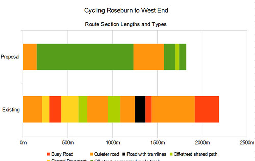 Roseburn to West End: Section Lengths by andy a, on Flickr
 Roseburn to West End: Section Types by andy a, on Flickr
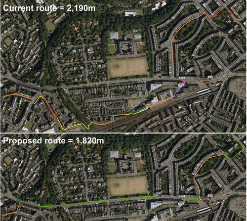 Roseburn to West End: Routes by andy a, on Flickr
Posted 10 years ago #
Roseburn to West End: Routes by andy a, on Flickr
Posted 10 years ago # -
I'm sure I've got a collection of clips showing rat-running drivers speeding/cutting the corner into Roseburn Gardens which may be useful to demonstrate just how safe and traffic-free Roseburn Place is. I could edit them all together if it would be useful?
Posted 10 years ago # -
Would also be cool to do a side-by-side comparison with the A8 route when the road is quiet, to compare the directness? Could backfire if it makes the road look too safe though :P
Posted 10 years ago # -
Are we sure that's a shared use pavement on Russel Road?
Posted 10 years ago # -
@Coxy - nope! I always assumed it was meant to be given the "segregation" delineated by the paving surfaces. I don't think there's signs to that effect though. I'm being generous to the quality of the route here.
Posted 10 years ago # -
pretty sure the path used to be shared use - the weird stretch of painted shared use that is supposed to link to Roseburn Park wouldn't make sense otherwise.
Posted 10 years ago # -
The switchbacks at the Roseburn path have an additional turn which adds about 40 metres. Openstreetmap is, as usual, more up-to-date than Google maps: http://osm.org/go/evfLIBZlf?way=5043491
Posted 10 years ago # -
@Stephan yes I've now updated the version I have as I had absent-mindedly traced the pre-tram access to the NEPN. Agree it adds 40m.
Posted 10 years ago # -
Would it also be worth adding an elevation profile for both routes? Pointing out that the alternative is not only indirect, it's also far from level around Haymarket Yards and the zig zags.
Posted 10 years ago # -
@panyagua I had a look at that, but decided against it because;
1 - I couldn't find anything that had the altitude resolution to show the NEPN embankment
2 - the overall height gain from Roseburn to the West End at Melville Street is a about 60 feet by either way, so climbing over the NEPN or up Haymarket Yards would be a little blip.
Posted 10 years ago # -
" I couldn't find anything that had the altitude resolution to show the NEPN embankment"
Will this do? (look at 4 to 5 minutes in):
https://connect.garmin.com/modern/activity/1164320267I think panyagua makes a good point and I find those zigzags a real PITA even on conventional bikes (and going down as much as if not more than going up). It would be good to illustrate that.
I'm away all weekend, but I would be happy to create two short Garmin traces of the two routes if you chase me for them!!!!Posted 10 years ago # -
"if you chase me"
But he'd never catch you...
Posted 10 years ago # -
@kaputnik Good work.
Perhaps instead of showing altitude you could show a plot of slope versus distance? I can see that with an altitude plot it's difficult to explain the issue, but slopes are perhaps more meaningful.
Posted 10 years ago # -
The pavement on Russell Road is only 'shared use' under the railway. When contributing to Openstreetmap in the past I've looked for signs and for the section parallel to the railway there are none - and I'm 95% sure that I made some enquiries with appropriate council staff to back this up.
Posted 10 years ago # -
Nice plots kaputnik.
To include the zigzags, I'd simply add another colour e.g. purple. The graphic serves its purpose of showing what a mish mash the current route is.
Posted 10 years ago # -
"The pavement on Russell Road is only 'shared use' under the railway. "
Pretty sure the next section towards Roseburn is (unless you mean that's a segregated pavement).
BUT
Shouldn't have to assume/guess!
Posted 10 years ago # -
Looking at Streetview there aren't any signs to indicate it is.
Posted 10 years ago # -
"Looking at Streetview there aren't any signs to indicate it is."
You mean the pavement from the zigzag towards Roseburn?
Posted 10 years ago # -
Utterly superb work. Love these.
Worry marking junctions where you have to give way?
Posted 10 years ago # -
@chdot: yes
Posted 10 years ago # -
But it is clearly a segregated pavement and should be signed as such. (I'm surprised that OSM doesn't mark this 'reality'.)
Of course it's a monument to failed planning (segregated pavement ought to have been a condition of next development along).
Even more - it's a failure of CEC not wanting to upset those who have a *right* to park on that road.
Posted 10 years ago # -
One of the officers at the consultation said that something went wrong with the Russell Rd connection which for some legal reason is difficult to fix. I didn't get details as some shopkeeper was shouting something next to me, but the way I understood it was that the developers of the Roseburn Maltings estate were supposed to create a link through the estate, but unfortunately now there isn't a connection between the south end of the estate and Russell Rd.
In a way it makes more sense for a "quiet route" to go through Roseburn Maltings instead of Russell Rd., but of course that would have added another set of tight corners and opportunities to get lost.
Posted 10 years ago # -
@HankChief: I filmed the NCN route from Haymarket today. Let me know if you could use it.
Posted 10 years ago # -
Thanks.
If anyone else has video's it, then please email it to me and I select the best one...
A bacon butty (with free on street parking) to the winner courtesy of the Roseburn Cafe.
HC
Posted 10 years ago # -
It was as I travelled to work yesterday, by a completely different route, that I remembered I was supposed to have done that. And today I had to take the car. Will give it a whirl tomorrow but I suspect Stickman has it covered :)
Posted 10 years ago # -
Don't want to read too much into this, but Frank Ross retweeted some footage of the packed London cycle paths. Perhaps he is slowly coming round? Or maybe he just hit the wrong button.
Related, also saw that Paul Edie will be standing down at the next election. Will be interesting to see if that influences his attitude to the proposals.
Posted 10 years ago # -
Even more interesting to find out what the candidates support (assuming they are known before this gets built).
Posted 10 years ago # -
Posted 10 years ago #
-
New York has the same issues with noisy local democracy...
http://invisiblevisibleman.blogspot.com/2016/05/a-cancelled-bike-lane-crowded-f-train.html
Robert
Posted 10 years ago #
Reply »
You must log in to post.
 posts
posts
