
@hankchief and Wingpig, you are describing their route very well.
CityCyclingEdinburgh Forum » Infrastructure
WoL path is very dry
(72 posts)-
Posted 8 years ago #
-
Quick question - is the WOL open again between roseburn and stockbridge.
New office is down that way and considering a mostly offroad commute on days I'm there. However that bit still being closed would scupper my plans. yarr.
Posted 8 years ago # -
Was going to say that you can just jump the fence but I see from Twitter that the council have erected a proper fence and also on Twitter ths the former transport convener has a good memory. For the record the landslide appears to have been caused by a private entity and getting them to pay up would spread yo be tricky (complicated by an inadequate repair). The detour works if heading to Stockbridge but if need to be on t'other side maybe not so good?
Posted 8 years ago # -
It was still passable a few weekend ago, so don't know how recent the Twitter fence is. Best bike diversion for the road-confident might be up past the hotel onto Belfort Road then back down Hawthornbank Lane. Steps required otherwise.
Posted 8 years ago # -
https://twitter.com/HalOsler/status/944185777004646405
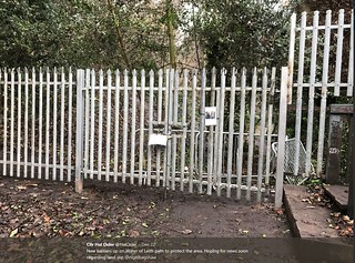 Capture by Paul fae Fountainbridge, on Flickr
Posted 8 years ago #
Capture by Paul fae Fountainbridge, on Flickr
Posted 8 years ago # -
There's a second closure too now - after the landslip detour, heading upstream, the path is closed from where it heads under the bridge at Belford Road. Till the spring, I think? Pedestrian detour in place, if you can do steps.
Posted 8 years ago # -
That metal bridge / pontoon under the stone bridge at Belford road is very corroded. Me no likee.
Posted 8 years ago # -
Anyone know if the council are doing something to Harlaw and threipmuir reservoirs? I was running past Black Spring this morning and the water levels were so low you could see the path of the burn from the spring.
Posted 7 years ago # -
@steveo, see various threads about low levels. Concerned resident had posted photo of thriepmuir in Currie anf blernae news. Second World War defences which were pokes to stop planes landing have emerged (on their sides)
Has been a dry year, someone will give us the stats if I assert it has been the driest in twenty years.
The river has water in it that might have really dried? No water in black springs, Harlaw of thriepmuir. Torduff and torphin levels look normal
Posted 7 years ago # -
Missed the earlier threads and I've not been up that way much since April so it was a bit of a surprise to see quite so much bank.
Hopefully dry next weekend, might go see if there is anything photographically interesting.
Posted 7 years ago # -
You bet, the locals were walking where the water was.
Posted 7 years ago #
Reply
You must log in to post.
 posts
posts
