
Kaputnik, that's a very tempting idea.
CityCyclingEdinburgh Forum » Events, rides etc.
Tour of East Lothian chimney farms
(148 posts)-
Posted 14 years ago #
-
Posted 14 years ago #
-
YOu did get a good day for it, I was out hunting pumpkins [in shorts and tee] to no avail in all major outlets (I am a turnip man myself but kids objecting ). Was a good day for gadding about.
Posted 14 years ago # -
Tom, when you are doing further research on the chimney farms, in the local library you could look up the Statistical Account of East Lothian. I have only seen volume one of the Fourth (1945-200) but it is full of local history and has contacts and references that may be useful to you. The older accounts should be even more relevant.
Posted 14 years ago # -
I have just realised that the not-a-chimney is non-standard in its brickwork as the tieing course is every 5th course.
Posted 14 years ago # -
@amir, thanks for that. I'll try to take an afternoon off and kgo out to Haddington Library.
@kaputnik: I'll go out and have a look at that when I'm visiting the chimney at the farm Amir spotted. It's odd putting a shaft on a hill - like the well in the old nursery rhyme.
Posted 14 years ago # -
I mentioned some mysterious towers or pillars (mentioned on map) that can be seen on the moor between West Linton and Penicuik (Auchencorth)
One at first sight seems to be within a fortified tower:
but the OS maps shows a line of pillars to the north (see OS map) just south of the river - not sure if these are connected with the first. I assumed these were ventilation towers for some mine.
The author of this page seems equally confused:
http://www.west-linton.org.uk/category/image-galleries/west-linton/local-industrial-heritage
However the first tower mentioned is explained by another 2 sources as "a sighting tower during the building of the Talla to Edinburgh water aqueduct." Also identified are the concrete pylons (which I haven't explored)
http://www.scottishbordersheritage.co.uk/50001
http://www.flickr.com/photos/27244534@N08/2638860390/
Not sure why the main tower apparent has a tower within a tower structure.
Posted 14 years ago # -
@amir interesting. I'd always assumed that the square "tower within a tower" structure had been a lime kiln, the remains of which are quite plentiful around Harlawmoor. The tower isn't there in 1855 sheet for Peebleshire, but is there in 1858 in a very small enclosed wood (Harlaw Wood) as a "pillar". It is on the high point of the surrounding land, so perhaps it was simply to mark this? There was historically a cairn on this site according to maps, perhaps again for same reason.
It pre-dates the construction of the aqueduct I think.I take that bit back. It sits directly over a bend in the water conduit, as do all the pillars now I have looked closer. Perhaps because of my observation that it is at the high point in the moor is why this particular pillar is a lot more substantial than the others.
As for the other towers you describe, on the OS 1:2500 sheet for Edinburghshire in 1894 there is nothing marked. Nothing at all, whole map square in this area is just bog! In 1907 there are some "pillars" marked and a tramway running perpendicular to them - assume this for aqueduct construction or perhaps hauling peats off the moor. 1908 sheet for Peebleshire has the aqueduct ("conduit" marked) and it runs directly underneath the line of pillars. The aqueduct can clearly be seen in the aerial image as can the trackbed of the tramway runnin perpendicular to it in a roughly southeasterly direction. 2 + 2 = problem solved?
Posted 14 years ago # -
Posted 14 years ago #
-
That's all sorted then (a long standing mystery to me).
BTW Deepsykehead long cairn seems to be more ancient?
http://canmore.rcahms.gov.uk/en/site/50228/details/harelaw+muir/
Posted 14 years ago # -
Perhaps there is an opportunity for another tour around that area? Lots of other industrial archeology (railways etc) plus we could pop in to Whitemuir for cake :>
Posted 14 years ago # -
"Whitemuir for cake"
Posted 14 years ago # -
Amir: "Perhaps there is an opportunity for another tour around that area?"
I'd be up for that.
Posted 14 years ago # -
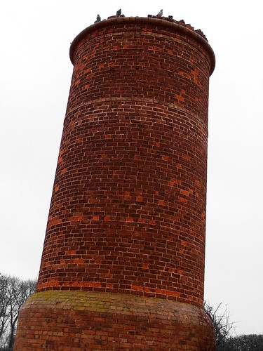
So we've had the "Chimney Sweep", what is this one to be called?
"moor or less"?
Posted 14 years ago # -
The Lammermuirs have this oddity:

Hopes Reservoir conduit by Cycling Mollie, on FlickrIt's a covered conduit taking water from the Hope Hills to the Hope Reservoir. It's about a kilometer long.
Posted 14 years ago # -
Le Tour des ToursLe Tour de les ToursLe Tour du ToursThe Tour of the Towers?Posted 14 years ago # -
Le Tour des Moors
Posted 14 years ago # -
"Le Tour des Moors " Looks like we have a name. Now what about a route?
Posted 14 years ago # -
Well Harlawmoor road is obvious, as it's a lovely cycle.
I think it would be nice to head out via Lothianbridge just before Newtongrance, to Carrington, then Temple, past Gladhouse Reservoir to Waterheads, down the A703 fir 2km then first right up past Shiplaw , coming out at A701 after Leadburn.
Other nice bit to take in are the Meldons (nicest to approach from South) Obvious quiet approach to Meldons from South is via Broughton.
Posted 14 years ago # -
That looks like a good route. There's quite a climb up past Macbiehill to get to Deepsyke especially if we've "prepared" for it with a visit to Whitmuir.
Posted 14 years ago # -
"I think it would be nice to head out via Lothianbridge just before Newtongrance, to Carrington, then Temple, past Gladhouse Reservoir to Waterheads, down the A703 fir 2km then first right up past Shiplaw , coming out at A701 after Leadburn."
A classic route, kaputnik.
Posted 14 years ago # -
Tom, that conduit looks like a levada cf Madeira
Posted 14 years ago # -
Tom, (or Dave), you may be interested in this property:
http://m.espc.com/?saleType=Sale&beds=0&locType=text&area=dalkeith&radius=0.5&longitude=0&latitude=0&house_type=12&min_price=200000&max_price=&search=Search&sort=price-ASC&p=3&propref=307119Posted 14 years ago # -
Someone is going to be the proud new owner of a hexagonal section chimney. Won't be me though at that price. Maybe one day.
Posted 14 years ago # -
Yes but now there's an excuse to put on your best suit and go round as a prospective buyer, but spend your whole time crawling around the chimney :)
Posted 14 years ago # -
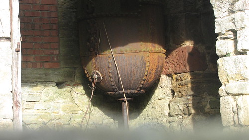
Not sure if this counts as a chimney - keep meaning to mention it. At the Duddingston crossroad, tucked away off the road, there is a chimbly type thing in metal - all spirally at the bottom. There's a burn running in a small gorge below it - what on earth would it be for? I've lived down that way a few years now and it has always got me wondering...
It's here. Though you can't see it very well... The undergrowth is a lot less multitudinous at the mo.
Posted 14 years ago # -
@anth Those two locations don't appear to match up - the chimney stalk is south of the Duddingston crossroads is SSW of the Google maps location, yet the view there is SSE. I think the distances don't match up either, as I think there is indeed something erected in that waste ground, not simply visible beyond it.
Robert
Posted 14 years ago #

Reply »
You must log in to post.
 posts
posts
