
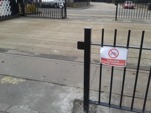
Anyone any idea what is going on there? Railings installed leaving a 6' gap in the middle with 'cyclists dismount' signs? Tell me they are not going to try & close the crossing to cyclists.
CityCyclingEdinburgh Forum » Infrastructure
Leamington Lift Bridge
(130 posts)-
Posted 14 years ago #
-
@stilts from previous post on this it looks like they are trying to create a bottleneck. Cyclists unless on new York city style narrow bike will have to push through. An injustice etc. but we will still get through where the cars can't, maybe have to wait a while for sure.
Posted 14 years ago # -
I did a few searches through CEC's planning portal yesterday and couldn't find anything for the lift bridge. It's absolutely amazing that on one hand we're getting new paint on the roads, new red chippings in tarmac, a QBC in the works … and then genuinely good traffic-free cycle routes suddenly have fences and gates foisted upon them. Top of the Innocent Tunnel, anyone?
Posted 14 years ago # -
I could be wrong, but the Leamington itself looks like one of the least conflicty parts of the whole canal. Compared to the rest of the bridges along it, it's got a bajillionty of room.
Posted 14 years ago # -
I think there is some confusion between feet (') and inches ("). The gap at the bridge is around 6 feet wide or 2 metres in new money.
The cyclists dismount sign is disappointing though.
Posted 14 years ago # -
Signs look temporary. I think they meant to put up 'wet paint' signs but this was all they had!
Yellow marking in for a drop bollard. Will be hinged one though. Maybe to do with access for emergency vehicles? Is bridge strong enough... ?
If they were to follow on putting cycling dismount signs then I'd expect every canal bridge to have one... now there's an idea! Nice little project .
Too many bikes? by LaidBackBikes, on FlickrPosted 14 years ago # -
From that pic it looks more like 'elf and safety got worried about the little chain that goes across when the bridge is raised and want something more substantial.
Posted 14 years ago # -
I cycled through this the other day and wondered why where previously bollards and lengths of chain had sufficed that (I assume) British Waterways were going to all this effort.
Looked like the current width of the bridge was being restricted deliberately by 2/3 - i.e. creating a bottleneck where no bottleneck was neccessary.
As we all know, del monté signs are strictly advisory only.
Will swing by that way this evening and then think about writing to BW to ask what they think they're up to.
Posted 14 years ago # -
I can't tell whether or not a drop-bollard implies that cyclists weren't the primary target.
Maybe it's to slow cyclists down to reduce the risk of interactions between cyclists and peds travelling perpindicularly. Maybe it's hoped that cyclists heading south will notice the no entry signs to Leamington Road during the extra couple of seconds required to re-mount after crossing.Whilst they were at it a set of bollards across the end of Gilmore Park (and the removal of the gate across the end of the basin-section of canal) would have been nice as it would stop brewery-destruction-related vehicles from parking on the Gilmore/Viewforth section of canal (and possibly also encourage cyclists to slow down when heading north/south).
Posted 14 years ago # -
would have been nice as it would stop brewery-destruction-related vehicles from parking on the Gilmore/Viewforth section of canal
it would also mean that if you're heading uphill on Gilmore Park you could see what's coming to your right along the canal, rather than the permanent fixture white van blocking your line of sight.
Posted 14 years ago # -
Maybe to do with access for emergency vehicles? Is bridge strong enough... ?
I suspect it used to be strong enough for double decker buses!
looks more like 'elf and safety got worried about the little chain that goes across when the bridge is raised and want something more substantial.
The bridge used to have something more substantial. In fact it still does, but its original concertina barriers were welded and chained up a long time ago.
Posted 14 years ago # -
As we all know, del monté signs are strictly advisory only.
Particularly ones that seem to say "no cycling", except with a symbol that means nothing - the official one being:

And the advisory dismount sign itself:

I love the irony that I ripped this from the below page!
Signs Used By Local Councils To Raise Awareness Of Cycling Activities - Cyclists Dismount
Robert
Posted 14 years ago # -
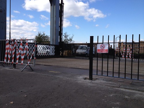
Untitled by blackpuddinonnabike, on FlickrI'm genuinely stumped by this. As has been said, it looks like they're simply beefing up the barrier from the chain that is currently used (and I'll bet they feel daft welding the concertina gates shut now).
That leaves a big gaps in the middle (the gates to fill these are leaning on one of the railings). But for some reason, while waiting for those to be put on, they have narrowed the gap more than it will be when the work will be finished, using some temporary barriers, on which the cyclist dismount signs have been placed.
Baffling.
A family of threee came through while I was there and all dismounted.
Posted 14 years ago # -
From that it kind of looks like the signs might just be there while the work is being done. And at least they are polite.
Posted 14 years ago # -
You can get more with a kind word and a 2x4 than you can with just a kind word.
I think (hope?) Min is right, give them a few days (weeks/months) to finish and see if the sign is removed or replaced with something in steel...
Posted 14 years ago # -
I was reading up on the bridge. A couple of interesting factoids were uncovered.
1 - the bridge is not in its original position. It was moved in 1906 (or 1920s, depending on the website consulted) to current location. Originally it was further up the canal before the Port Hopetoun / Port Hamilton basins were filled in.
2 - The decking was originally wooden, but replaced with concrete and tarmac when it was relocated. The current wooden decking was installed when the bridge was refurbished for the Millennium link. It may therefore no longer be up to taking double-decker busses. Certainly not the current 15 tonners.
Posted 14 years ago # -
I had a quick poke to see if anywhere clearly stated the current bearer of responsibility for its upper surface; whilst it crosses a British Waterway it's sort of also a usually-the-council road. It had just permitted a boat to flee when I went past at lunchtime so had the wee chain in place as well as the new barriers and the gap-narrowing lashed-on portable fence.
Posted 14 years ago # -
Seems that the bridge used to be half way up (down) Semple Street, roughly aligned to where the underground carpark for Scottish Windows now is.
Also it seems that in the process of buildinng first the extenstion of the North British Rubber's Castle Mills and then the Fountain Brewery, the streets of Gilmore Park Lane and Freer Street were lost. I wonder if those names might be re-used in the new development.
Posted 14 years ago # -
in answer to my own question it would seem that the plan is to create a pedestrian thoroughfare as part of the redevelopment of the "Tartan Club" site called New Freer Street.
Posted 14 years ago # -
It lies adjacent to the highly successful Edinburgh Quay development,
As a measure of success is "mostly empty eatery boxes turning over every 6 months with a mostly empty ugly office complex blocking the sun most of the day" a good metric?
Posted 14 years ago # -
Edinburgh is chronically short of empty offices. Or so the people responsible for developing empty offices keep saying.
Edinburgh needs more empty offices. And student "villages". They're always good for a quick buck or two.
Posted 14 years ago # -
That office building at the basin that we discussed on some other thread appears to be getting tenants finally. Certainly there's a lot of work going on, and looks like a kitchen going in on the first floor.
Posted 14 years ago # -
"Edinburgh is chronically short of empty offices. Or so the people responsible for developing empty offices keep saying."
They are needed for jobs for all the people who don't live in all the empty Luxury Apartments.
Posted 14 years ago # -
And quarters. By my reckoning we're dangerously low on quarters. At last count we only had about 7 or 8.
Posted 14 years ago # -
"Come to Edinburgh. More than the sum of its parts."
Posted 14 years ago # -
"Come to Edinburgh. Smaller than you'd imagine given what we've told you"
Posted 14 years ago # -
Kaputnik, The original location of the bridge is on Fountain Bridge just before Gardiners Cres heading west. If you stood on the pavement next to the Cargo and the passage / archway to the canal and looked over the brow of the hill, north towards where the Coop Funeral services used to be you've be standing on a canal barge heading under the bridge. The building north of there is now rectangular but used to be a stone building with a left hand bend to the rear where the canal used to turn east towards Hopetoun Basin. I have a book with arial photos showing the bridge in its original location and the Canal basin where the cinema is now.
Posted 14 years ago # -
Edinburgh is chronically short of empty offices. Or so the people responsible for developing empty offices keep saying.
They are needed for jobs for all the people who don't live in all the empty Luxury Apartments.
Some nice new empty offices further down McDonald Road, behind which are some nice empty luxury flats. Can't wait for the next lot to be built on the site of the old Leith Walk tram depot (currently being cleared), not-so-old but recently demolished Brunswick Street PO sorting office, Lochend triangle, etc.
Posted 14 years ago # -
@DaveC interesting - there is a bridge marked there on the old maps, but it is the one into Port Hamilton at Semple Street that is marked as a draw bridge. So perhaps there were 2 lifting bridges?
The Hopetoun / Hamilton basins closed in 1922, so I assume that is when they moved the bridge as the original one at Gilmore Park was a narrow stone arch.
Posted 14 years ago # -
Posted 14 years ago #
Reply »
You must log in to post.
 posts
posts
