CityCyclingEdinburgh Forum » Infrastructure

Peebles to Innerleithen

(83 posts)

  1. cb
    Member

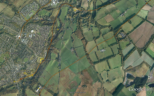
    Driving out of Innerleithen at the weekend I noticed new tarmac on the old railway line.

    I hadn't been aware of this:

    http://www.bikeradar.com/news/article/new-off-road-route-linking-innerleithen-glentress-and-peebles-29659/

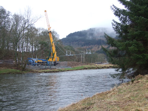
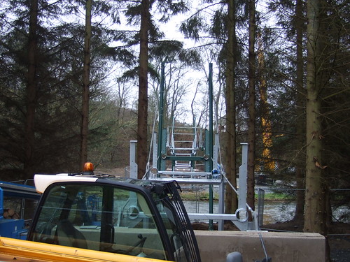
    Including a new bridge over the Tweed at Cardrona.

    And all for £800,000. That's about 1.3 QBCs.

    The Eshiels tunnel at the other end of the route has already been done:

    http://www.geograph.org.uk/photo/1850371

    http://www.geograph.org.uk/photo/1850339

    http://www.geograph.org.uk/photo/1850350

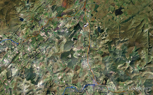
    Could do with some tarmac. Obviously this path will link some well used mountain biking areas, but as a route between Peebles and Innerleithen it should be pretty quick and flat for all bike types.

    Posted 11 years ago #
  2. Funnily enough I was speaking to a guy I work with who lives down that way who mentioned this route should be finished soon - from what you've seen sounds like it could be pretty damned good (and the road from Peebles to Innerleithen is one that, while rideable, has a lot of fast stretches, and more than a few narrowing twists, so a good off-road alternative should be well used!).

    Posted 11 years ago #
  3. steveo
    Member

    Errm, there is a very quiet road on the other side of the tweed between iners and Peebles, I've ridden it many times and you'll barely see two cars an hour... It does have some little kickers hills though.

    Posted 11 years ago #
  4. That doesn't start till around Cardrona doesn't it? Mind you, that's still not far out of Peebles I guess. But aye, as a nice easy-going family route, eliminating those kickers of hills (and there are more than a few!) would be good to encourage people out (and quiet though some roads are, a lot of people still see them as 'roads' and those must be avoided...)

    Posted 11 years ago #
  5. wingpig
    Member

    Whoah. Wandered that a few years back when it went through sheepfields, brushed against the embankment the main road sits on then zigzagged through the horror of Cardrona, where the evil golfer-housing developers appeared to have nicked some of the old trackbed (similar to the horrible houses on the WoL where the path now has a big kink in it). Any plans to tarmac in the other direction, through the nice unlit tunnel and Stobo-wards?

    Posted 11 years ago #
  6. chdot
    Admin

    "Any plans to tarmac in the other direction, through the nice unlit tunnel and Stobo-wards?"

    Good question!

    http://citycyclingedinburgh.info/bbpress/topic.php?id=1587&page=10#post-83905

    Posted 11 years ago #
  7. Dave
    Member

    The road on the south side of the valley links Peebles with Peel - 16 miles with a few climbs VS 14 miles pan flat. Quite a nice route really, although if it wasn't peak time I think I'd just churn along the main road.

    Posted 11 years ago #
  8. cb
    Member

    The new path will link with Glentress which the B7062 doesn't. Should be attractive for people who want to hire a bike in Peebles or Innerleithen.

    Posted 11 years ago #
  9. slowcoach
    Member

    "you'll barely see two cars an hour" ... peak flows are nearer 70 - 80 cars per hour http://www.transportscotland.gov.uk/files/InfoMapper/hot/JTC08210.htm

    "That doesn't start till around Cardrona doesn't it?" ... B7062 is between Peebles High Street and B709 at Traquair (B709 then links to Innerleithen)

    "Could do with some tarmac" ... there is now more tarmac than in the photos above, and last I saw the tar stretched from Janet's Brae near Peebles Hydro to the junction with the track to Glentress main entrance. That track hadn't been finished then, and the rail path through the golf course nearly to the B7062 had a smooth dust surface.

    Quiet though the B7062 and B709 usually are, there can still be collisions between users: http://citycyclingedinburgh.info/bbpress/topic.php?id=8647#post-87411

    Posted 11 years ago #
  10. cc
    Member

    Quite a nice route really, although if it wasn't peak time I think I'd just churn along the main road.

    @Dave: just out of interest, why? Is the cycle path too narrow for instance? What I'm wondering is what could be improved about the cycle path to make you prefer it to the road.

    Posted 11 years ago #
  11. shuggiet
    Member

    Anyone know where the new route is mapped? I can't see it on cyclestreets, Google or Sustrans...Sounds like a good family route to take..

    Posted 11 years ago #
  12. chdot
    Admin

  13. Dave
    Member

    "@Dave: just out of interest, why? Is the cycle path too narrow for instance? What I'm wondering is what could be improved about the cycle path to make you prefer it to the road."

    I meant the road on the north side of the valley rather than the south.

    Posted 11 years ago #
  14. slowcoach
    Member

    Plans of the route including drawing of the bridge (foundations built) are at http://eplanning.scotborders.gov.uk/online-applications/applicationDetails.do?activeTab=documents&keyVal=JTK1HPNT00800 application no. 07/02462/FUL.

    nearer future ? "09/00975/FUL | Change of use from former railway line to multi use path and construction of new pedestrian bridges | Former Railway Line Between Leadburn And Eddleston Scottish Borders" http://eplanning.scotborders.gov.uk/online-applications/caseDetails.do?keyVal=KN2ZJBNT00800&caseType=Application

    Posted 11 years ago #
  15. slowcoach
    Member

    The new bridge over the Tweed for the Peebles-Innerleithen path has started to appear:

    fitting through a small gap in the trees from the south side:

    Apparently it will be at least a month or two until it is finished. Some of the linking path is still quite rough while the construction traffic uses it, and contrary to one of my earlier posts, section between Janet's/Jenny's Brae and the Glentress/Eshiels spur isn't all tarred - the bit past the Council roads depot has a grit/dust surface (perhaps to avoid damage from possible use by big vehicles, this bit is also much wider?).

    If you're using the path to Glentress, take care when crossing the A72. Someone was seriously injured there last week, apparently hit by a car while trying to cross the road.

    Posted 11 years ago #
  16. Charterhall
    Member

    Re the Leadburn to Eddleston path, does anyone know the current status ? I see from the link posted by Slowcoach that permission was approved but that was some time ago. Has there been any progress since ? And are there any plans to open it all the way to Peebles ?

    Posted 11 years ago #
  17. cb
    Member

    "fitting through a small gap in the trees from the south side"

    That's impressive. Usual form in these situations is to fell about 16 acres of trees.

    Thanks for the pics.

    Posted 11 years ago #
  18. cc
    Member

    I wonder what the chances would be of extending this path network to Edinburgh. A number of my colleagues (here in Edinburgh) live in Peebles and without exception they commute by car, at least as far as Edinburgh, as the only alternative is Worst Bus. None of them fancies cycling on that lethal road to Peebles. There used to be a railway from Peebles to Edinburgh - so maybe there's a track bed that could be used?

    Posted 11 years ago #
  19. chdot
    Admin

    "A number of my colleagues (here in Edinburgh) live in Peebles and without exception they commute by car"

    Any carsharing?

    Posted 11 years ago #
  20. gembo
    Member

    Roslin to Penicuick path is old railway, not sure where it goes on to.? Feel there was some correspondence on here about it being extended? Cycling to Glentress?

    Posted 11 years ago #
  21. chdot
    Admin

    Posted 11 years ago #
  22. kaputnik
    Moderator

    Roslin to Penicuick path is old railway, not sure where it goes on to.?

    The Penicuik path (goes through Roslin Castle, not Roslin itself) was a dead end branch to serve the papermills in the Esk Valley. There was a higher-level line that came from Loanhead and Roslin, but it didn't have a passenger station beyond Glencorse ,instead it was mainly for coal (there had been a pit at Mauricewood, scene of a major tragedy in the late 1800s).

    There was a third railway passing by Penicuik, which was the line to Peebles, it ran through Pomathorn and then to Leadburn, where there was a junction. You could get a train to the end of the North British line at Dolphinton, you could then walk across the road to the Caledonian Railway's station and get on a different train to take you in the direction of Lanark. Nobody ever thought to join those two railways in a convenient way.

    Peebles was also a junction of 3 different railways and had an inconvenient arrangement of stations.

    Posted 11 years ago #
  23. gembo
    Member

    Thanks Kaps

    Looks like the Penicuik path must just stop...?m I come off before the end to head to Glencorse via Mauricewood?

    Lovely maps

    Posted 11 years ago #
  24. kaputnik
    Moderator


    Penicuik in old railways by the Magnificent Octopus, on Flickr

    (click for details)

    Posted 11 years ago #
  25. kaputnik
    Moderator


    Peebleshire in old railways by the Magnificent Octopus, on Flickr

    again click for details. The line in the Penicuik map that runs through Pomathorn is the one that runs on to Leadburn (it crossed the road at about 45 degrees) where there was the junction towards Dolphinton. If you head east past Cardrona, the next stop was Innerleithen.

    Posted 11 years ago #
  26. amir
    Member

    "A number of my colleagues (here in Edinburgh) live in Peebles and without exception they commute by car"

    I did meet a guy cycling in the Moorfoots once and he claimed to be commuting.

    Posted 11 years ago #
  27. cc
    Member

    Wow lovely maps and info, thanks! Re car-sharing, I know of a husband/wife car share but I'm not sure whether that really counts :-)

    Re the Moorfoots commuter - I was thinking of the tragedy not so long ago when a man on a bike was slaughtered just outside Peebles on the Edinburgh road.

    Posted 11 years ago #
  28. Arellcat
    Moderator

    A surprisingly readable account of the railway's conception and day to day running, and the competition between railway companies.

    Posted 11 years ago #
  29. kaputnik
    Moderator

    I find it charming and quaint that in the early days of the Peebleshire railways, the railway companies ran competing express trains from the Borders to the central belt - the Caledonian running its Tinto Express against the North British Peebleshire Express. I suppose it was worth the ticket receipts brought in by Borders gentry and mill owners.

    Posted 11 years ago #
  30. AKen
    Member

    Whilst a proper conversion of the railway from Peebles towards Edinburgh would be wonderful, it would be very expensive for each commuter likely to use it - climbing the hill up over to Leadburn in the winter would sort out the commuting men from the commuting boys (or girls).

    Posted 11 years ago #

RSS feed for this topic

Reply »

You must log in to post.


Video embedded using Easy Video Embed plugin