CityCyclingEdinburgh Forum » Infrastructure

Murrayfield - Saughtonhall: Water of Leith Path Resurfacing

(89 posts)
  • Started 11 years ago by Radgeworks
  • Latest reply from Rosie

  1. Stickman
    Member

    ""[the designers] didn’t want to send the message that it was a ‘motorway' for cyclists"

    Depends on your interpretation of "motorway". If they'd said "speedway" I'd be in full agreement; it's a shared path and there are enough numpties racing.

    We're. It going to get segregated routes, so let's hope that this one is an improvement.

    Posted 9 years ago #
  2. Stickman
    Member

    The path is reopen. Looks like the stadium side of the path is completely clear of trees/vegetation.

    Posted 9 years ago #
  3. chdot
    Admin

    "completely clear of trees/vegetation"

    Sounds like CEC's Year Zero way of implementing flood prevention measures.

    Posted 9 years ago #
  4. Nelly
    Member

    So, do we know if it will be some tarmac-like substance or whin dust ?

    Could make an interesting extended route home for me.

    Posted 9 years ago #
  5. Dave
    Member

    +1 if it gets a proper surface.

    I only discovered the path beside the tram works last winter and it rivals the towpath for my preferred route (you have to ride from the canal to Edinburgh Park instead of from the canal to NEPN, so it's even on the crap traffic score, and otherwise faster riding).

    This is the one bit of mud, so if they were able to put a decent surface on, I doubt I would use the towpath much at all (unless they remove the mud on the WoL path with a proper surface).

    Posted 9 years ago #
  6. Fountainbridge
    Member

    Where was the path parallel to Baird Drive? There might have been a space between Baird Drive and the railway lines but this has been taken up by the tram. Don't think there's much space left.

    Years ago a couple of the Murryfield playing fields parallel to the WOL were due to become flood planes. SRU complained and said they'd rather pay to have the WOL widened in to their own land, but built with higher embankments to prevent their playing fields from flooding. I'm guessing CEC have allowed this as SRU were going to pay.

    These seem to be the active plans for the area - https://citydev-portal.edinburgh.gov.uk/idoxpa-web/applicationDetails.do?activeTab=summary&keyVal=JWHQWQEWQ0000

    Posted 9 years ago #
  7. neddie
    Member

    There were a couple of surveyors there this morning taking measurements.

    I wonder if there'll be a signed pedestrian/cyclist diversion in place when they start the works? Or will it just be "Footpath Closed"?

    Posted 9 years ago #
  8. chdot
    Admin

    "I wonder if there'll be a signed pedestrian/cyclist diversion"

    Good question.

    I think CEC is *supposed* to...

    Posted 9 years ago #
  9. Stickman
    Member

    There was a signed diversion (with map) when it was closed for the tree work a few weeks ago.

    Posted 9 years ago #
  10. Police had parked up their van beside the bollards at the entrance to Murrayfield Ice Rink this morning at around 6.20-ish and were setting off along the newly-cleared path.

    No idea what they were off to investigate / check out.

    Posted 9 years ago #
  11. LivM
    Member

    Was walking back along the WOL after Polwath sale today and found a sign warning that the bit just upstream of the Ice Rink was closed because a wasps nest had been disturbed...

    Posted 9 years ago #
  12. Stickman
    Member

    The side of the path beside the stadium has been excavated for gas mains replacement. Will the upgrade to the path be done as part of this? Or will the usual approach be taken, i.e. dig the whole thing up again in six months?

    Posted 9 years ago #
  13. neddie
    Member

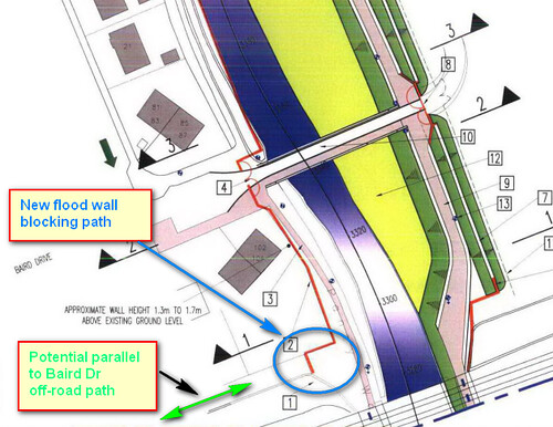
    It seems the new flood wall will permanently block off the potential off-road path parallel to Baird Dr:

    WoL flood prevention2 by Ed, on Flickr

    From: http://citydev-portal.edinburgh.gov.uk/idoxpa-web/files/B6B78EAAB4D56B11E193A2A4EC2BE5D8/pdf/08_00609_FUL-MURRAYFIELD_SOUTH_PLAN_SHEET_1_OF_2__04_-654248.pdf

    So any hopes of a complete off road route between the Broomhouse path and the WoL path are now shattered.

    Also, they are building 2 new bridges (to replace existing ones) - no expense spared on this scheme. And yet it is "impossible" to build a bridge over S. Gyle Access or to connect the Roseburn path up to Dalry (over the rail tracks & over Dalry Rd.)

    Posted 9 years ago #
  14. chdot
    Admin

    Can't say I'm surprised at this.

    Flood prevention schemes are a bit like the tram scheme was - blinkered to wider consequences and potential benefits (look at the narrow paths with right-angled bends up the Braid Burn) and a 'we know best, must get done' attitude.

    I'm not suggesting it shouldn't be done (I know someone who was flooded twice by the WoL).

    Posted 9 years ago #
  15. Fountainbridge
    Member

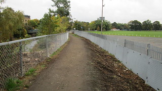
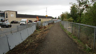
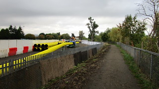
    One side of the path has been completely cleared. I'm guessing there's a big gas main under the path that will have to be moved.

    151011091925IMG_3573 by Paul Fountain, on Flickr
    151011091919IMG_3572 by Paul Fountain, on Flickr
    151011091808IMG_3570 by Paul Fountain, on Flickr
    151011091808IMG_3570 by Paul Fountain, on Flickr

    Posted 9 years ago #
  16. Stickman
    Member

    There's a new sign in Roseburn Park explaining the current gas works and the diversions that will be in place for pedestrians/cyclists.

    Slightly concerning is that a new track of metal plates has been laid across the grass. If this is going to be a diversion then it is totally inappropriate for cycling - you'd be better off on the grass. Will wait and see...

    Posted 9 years ago #
  17. kaputnik
    Moderator

    I noticed the track across the grass today and naively assumed it was for construction vehicles...

    If that is the diversion, It doesn't seem like it will be possible to get between the park and Riverside Crescent as it looks like the bridge will be blocked off?

    Posted 9 years ago #
  18. I noticed the new temporary path across the grass yesterday, but thought it looked like transparent plastic rather than metal.

    Took a better look this morning, and I think @kaputnik's right - doesn't look like there will be any exit from the park to Riverside Crescent. However, doesn't that also mean that there's no way for cars to get to the Ice Rink car-park? Wonder how that will go down?

    Posted 9 years ago #
  19. Checked this again last night and this morning as I passed. It does appear to be sheets of metal rather than plastic (which will incredibly slippery when wet and no fun on a bike if intended for bikes & pedestrians).

    It also curves back round to meet up with the road coming across the water and into the ice rink car-park, so it looks like access for pedestrians & vehicles to/from Riverside Crescent will be maintained.

    Posted 9 years ago #
  20. Stickman
    Member

    Lots of fencing up along the length of this new track. Looks like the diversion may be in place soon.

    Posted 9 years ago #
  21. LivM
    Member

    The sheets are definitely plastic, well the ones I fondled today were anyway. They have little raised dashes on them.

    Posted 9 years ago #
  22. LivM
    Member

    It's this stuff: Endura Mat

    Posted 9 years ago #
  23. Been off the bike this week with a cold that's refusing to shift - have they laid the vehicle or pedestrian type of Endura Mat? I see it only claims to be suitable for pedestrians and vehicles - no mention of bikes....

    May have to change my route slightly to avoid the park until the work's done.

    Posted 9 years ago #
  24. The route through Roseburn Park had been blocked off yesterday during the day, so my ride home required the use of the 'Endura Mat' path.

    There's a feeble attempt using some woodchips to provide a wee 'ramp' up onto the path which will likely disintegrate in a day or two. The path itself is fine when ridden slowly in the dry. However, riding it this morning when it was covered in early-morning dampness was a little more squirrely, and my rear wheel spun uselessly at one point when I'd slowed to a near-stop and then tried to pedal off again.

    Best ridden with extreme caution and at walking pace - or possibly even better getting off and pushing if it's wet or frosty.

    Posted 9 years ago #
  25. kaputnik
    Moderator

    It's now possible to access Riversdale from the A8 again, so I've taken to turning off there for now rather than deal with the slidey matting.

    Not so easy in reverse though as a right turn onto the A8 is quite difficult to achieve if someone doesn't press the pedestrian crossing button.

    Posted 9 years ago #
  26. Fountainbridge
    Member

    Dave Hinnikers video of diversion path. don't fancy being on it in the winter

    [+] Embed the video | Video DownloadGet the Video Plugins

    Posted 9 years ago #
  27. HankChief
    Member

    Not so easy in reverse though as a right turn onto the A8 is quite difficult to achieve if someone doesn't press the pedestrian crossing button.

    I do that turn regularly and often find myself willing passing peds to press the button and then get deeply disappointed when I've put all my hopes on a suitable candidate only to find them walk past it.

    It's actually a bit nicer just now with Riversdale blocked as you don't get pressurised by motor vehicles behind you in the queue.

    Posted 9 years ago #
  28. kaputnik
    Moderator

    Some rather amateur looking "cyclists and scooters dismount" signs up at the start to the plastic board diversion. I slithetes along the sodden grass instead, as had many others judging by the tyre tracks. Wet grass seemed a safer option, it was nowt to do with the sign.

    Posted 9 years ago #
  29. Stickman
    Member

    I free wheeled along it this morning with one foot unclipped as a precaution. It's not actually that bad.

    Posted 9 years ago #
  30. Saw that sign this morning, @kaputnik. Hand-written by persons unknown - I've tweeted the council to ask if it's theirs or the contractor's sign ;-)

    Wouldn't it be nice if, for once, a signposted alternative route for cyclists was provided when a signed cycle route was closed off, rather than being told to get off and push? After all, they'd never close a road to cars without providing an alternative that didn't require them to get out and push their vehicles.

    Posted 9 years ago #

RSS feed for this topic

Reply »

You must log in to post.


Video embedded using Easy Video Embed plugin