
dougal, thanks for clarifying the situation and that it is quite dutch. I'm looking forward to showering whatever consultation happens with praise. This will make my commute directly and measurably more pleasant - bring on the London Rd portion if this is what's lined up.
CityCyclingEdinburgh Forum » Infrastructure
Leith Walk Project
(1172 posts)-
Posted 11 years ago #
-
It's looking great. My only concern is the bottom drawing of the "tram concept", with a shallow-angled exit from the cycle path straight onto the tram tracks...
Posted 11 years ago # -
Big row on twitter with carsickglasgow and cycling embassy of GB claiming it's all crap
Posted 11 years ago # -
@SRD I just about take their point about the lack of continuous lane at Pilrig Street (but assuming they have failed to note it's traffic-light controlled so not the worst thing in the world, although a continuous lane/table would be preferable to reduce risk of left hooks and "there's a gap"ers turning right into PSt), but the rest of their issues seem to fail to take into account the influence of the existing layout North of PSt?
All things considered it looks pretty good to me and suggests road designers have been paying attention to some good examples in Europe. Will study in more detail before making any response to CEC.
Posted 11 years ago # -
Just having a look at this now. What solutions are there for placing the bins? Any ideas?
Posted 11 years ago # -
I thought all bins were being placed on the carriageway (i.e.. no longer on the pavement as currently).
Posted 11 years ago # -
i;
We should lobby for static sunken bins to be used the whole length of the street. They have large underground volume so you need less of them and they're far more attractive than any of the portable bins currently used
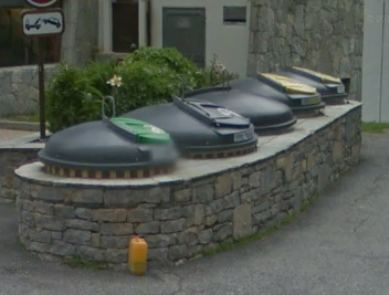
Edinburgh already has a couple in parks, so they're not an entirely new concept. That top installation takes about the same space as 2 cars, so not big either.
Posted 11 years ago # -
@Klaxon. Good idea! That reminded me of the bins I used in France, you need to have a bin lorry with a crane to hoist it out the hole to dump the contents into the lorry container before lowering the bin back in the hole. Maybe Edinburgh already has those sorts of bin lorries.
Posted 11 years ago # -
For ease of comparison I've uploaded png versions of the old "option 2" proposal and the new one.
http://i.imgur.com/4DKTvp0.jpg
http://i.imgur.com/6xaJiX9.jpgAnd to compare with my designs before consultation:
http://i.imgur.com/UQ4NJ8T.jpg
And after consultation:
http://i.imgur.com/989K8Kw.jpgPosted 11 years ago # -
This all looks very positive. Just wanted to pick up on Klaxon's point from yesterday, in which they noted that at one of the side streets the cars have to give way to the bike lane, but there are also give way marks on the cycle lane. This appears, effectively, to be an 'everyone give way' junction.
I appreciate that the designers probably had in mind that drivers will not be very used to giving way to cycle lanes, and so cyclists should be a little bit cautious. But as drawn it's not clear that cyclists have priority over the turning traffic and this is something that we should get remedied. We could do with something that makes it totally unambiguous that the cyclists have priority, even if it also reminds cyclists to beware of bad drivers ignoring cyclists priority...
Posted 11 years ago # -
I'm coming back round to thinking the radius of the corner is too big / fast if the driver is meant to slow and give way immediately after. I pedaled down St Leonards St today and noted they're narrowing one of the sideroad entrances (Bernard st maybe?), with a much tighter radius at the corner - no-one will be doing 25mph round that corner. No point expecting slow caution on a corner cut like a slipway.
Posted 11 years ago # -
We have a shared use path along a busy road in Dumfries, and the side roads are quite nerve-racking - you have to slow right down and make like an owl to be sure that there's no car coming up behind you about to swing across your bows. I find that the Glasgow London Road segregated lanes feel safer because the kerbs make the corners tighter (and also you feel more as if you are 'in the road' than if you're cycling on the pavement, even with the kerbs).
Posted 11 years ago # -
These plans are so very, very far from what's needed.
Priority for cyclists over side roads is non-negotiable, as far as I'm concerned. This is an essential feature of Dutch infrastructure. It ain't Dutch without it.
There does not appear to be much in the way of substantial segregation - the cycleway is right next to the road. If it's built like this, drivers will park on it - because they love getting in the way, or because they want to avoid inconveniencing other drivers, or out of sheer habit. There will be no effective enforcement.
The traffic light junctions are also very poor. It's just more of the same - ASLs, central cycle lanes, toucan crossings. Infrastructure with a proven record of being useless. There is only one way forward - dedicated traffic lights and phases for cyclists.
I would also note that the pavements are unacceptably narrow in a number of locations. This will significantly worsen the quality of the pedestrian experience and may cause resentment. This is, of course, the intention of such designs. Scotland's transport establishment really doesn't like having to pretend to adjust to this new cycling thing - they'd much rather go back to what they know best, which is cars cars cars, and any route to that goal will do.
Posted 11 years ago # -
This is, of course, the intention of such designs.
Really?
Posted 11 years ago # -
I think the designs could be further improved. However, lets keep this all in perspective. The Council could just have resurfaced the road and the majority of people would have been happy. This isn't some conspiracy against cyclists. It is politicians and designers trying to balance competing needs on a mixed use street. This is a marked improvement on previous schemes, e.g. the Quality Bike Corridor. That has to be a good thing - the Council are learning and becoming bolder in pursuing cycling schemes.
Please suggest improvements, but don't put the boot into people who are actually trying to improve things. What will that achieve?
Posted 11 years ago # -
I think it is a huge improvement on the earlier proposals. I will be very supportive when this is consulted upon, though noting some things could be improved further.
Posted 11 years ago # -
These layouts propose a mostly good street layout. The stuff like give ways is paint and can be changed later. It's important it gets built.
My main remark will be asking for the complete closure of Brunswick St at Leith Walk. It's exclusively used as a rat run, has the worst cycle interface on the proposal and the open public space would well compliment Vittoria's already successful outdoor seating area and the budding local businesses opening up just off the corner.
Posted 11 years ago # -
"My main remark will be asking for the complete closure of Brunswick St at Leith Walk. "
Good point. Perhaps add the caveat "while retaining permeability for cyclists". Bollards should do the trick...
IIRC the only reason the street is still open is because until a few years ago, there was an ambulance depot on the street.
Posted 11 years ago # -
My main remark will be asking for the complete closure of Brunswick St at Leith Walk.
Unlikely to happed due to access for Leith Walk Primary? But could be closed just beyond the school, where West Montgomery Place is already blocked off.
Posted 11 years ago # -
@ k you're thinking B Rd.
Depot became exhibition space -
https://www.facebook.com/pages/The-Old-Ambulance-Depot/118281128250747
Don't know what it is used for now.
Posted 11 years ago # -
@ k you're thinking B Rd.
Of course. I stand corrected, like the man in orthopaedic shoes.
Still my opinion on Brunswick Road stands.
Posted 11 years ago # -
What is that building site next to Shrub Hill Lane? Since it has a side road that the new proposals show bikes giving way to.
Posted 11 years ago # -
@ kaputnik and chdot
Why not both? Especially since there's a primary school in the area.Posted 11 years ago # -
What is that building site next to Shrub Hill Lane?
It's a big housing development by "Places for People" (a conglomerate of housing associations), including demolition and replacement of the existing Masonic Club at the end of Shrub Place Lane (meaning the latter can be closed off). It has the usual bullsh*t convoluted non-segregated pedestrian/cyclist route through the development. The design statement refers to these as "staggered inter-connection lines through different levels of privacy" (!). There will also be a triple tram-rail set into the paving surface (2 running rails and a cable slot) as a nod to the site's origin as a depot and power house for the cable hauled tram system.
See planning application 15/00643/FUL for full details.
Posted 11 years ago # -
"
Dear Stakeholders,
Leith Programme Stakeholder Update 71
The Foot of the Walk junction works:
The contractors carrying out the upgrade works to the Foot of the Walk junction (MacLay Civil Engineering Ltd) continue to make good progress with the current work sections and anticipate that, everything going as planned, they should finish at the end of May.Following the completion of the footway works at Crown Place to Duke Street and the Constitution Street to Duke Street sections, the contractors are now concentrating on the area around Kirk Street to Great Junction Street and the public realm space adjacent to the Kirkgate shopping centre. Traffic islands have now been removed, lighting columns relocated, and kerb-lines changed. A new gully will also be installed at the Constitution Street junction to help improve drainage at this location.
Looking ahead:
· Continue slabbing work around Kirk Street/Great Junction Street section
· Continue slabbing works in front of Kirkgate and install new tree pitsCarriageway Resurfacing
Carriageway resurfacing has commenced in the area at the Constitution Street and further details on this element of the works will follow in a future update.Draft designs for the next phase of works:
Draft designs are being developed for the next phase of the Leith Programme works between Pilrig Street and McDonald Road. In line with the priorities of the Programme, the designs aim to enhance the area for pedestrians and cyclists while prioritising public transport needs and retaining loading and unloading facilities and some parking. The draft plans can now be viewed on the Council website.The statutory consultation on proposed designs will begin in late June and in advance of that, a drop-in session for anyone interested will be held in McDonald Road Library’s Nelson Hall on Thursday 11 June from 4pm to 8pm where we look forward to hearing people’s views on the proposals.
If you have any queries or require further advice or information then please don’t hesitate to contact me.
Regards
Alan"
Posted 11 years ago # -
@kappers: I note the following with respect to that application:
"Amendment to approved application 05/03128/FUL. Amendments to include: 1.Car park layout reduced. 2.Removal of commercial offices (BlockA) & substitute with residential. 3.Redesign flat layouts/cores/mix. 4.Public Realm Redesigned. 5.Revise elevations."
Posted 11 years ago # -
Looking at the 'hard works' landscape plans, the 'shared surface' areas look pretty cyclable, except the steps at the western edge. It looks like Dryden bridge will continue to be shut off by a gate, emergency access only. All the car parking is underground and no vehicular access at ground level on site so it might actually make a pleasant alternative to the eastern part of McDonald Road...
Posted 11 years ago # -
It looks like there's an inconsistency in the shrub hill proposals and this proposal:
See the differences in the side entrance (which goes down a ramp into the underground carpark. Which is correct?Why do I think this is important? Its a chance for some joined up planning; if Block A is place correctly, then a side junction with adequate space for walkers, drivers and bicycles could be made.
Posted 11 years ago # -
Key point's from this weekend's inflammatory clickbait
Cyclists say Leith Walk bike route is ‘shambles’
really?
Locals reacted with anger to the diagrams,
https://en.wikipedia.org/wiki/Weasel_word
Mr Harding said the plans should be adapted so that drivers on cross streets give way
A minor paint change to make a big difference. Hardly a shambles.
Ra ra ra ra trams 850m
Yawn
Posted 11 years ago #
Reply »
You must log in to post.
 posts
posts
