
In the spirit of Christmas I necrobump this totallly whacky thread. @SRD introduces us to Simon and his “niece Tilly” though there is another thread somewhere with SImon claiming men and women follow road signs differently that didnt end well for him either where he has to ask SRD - Is that a compliment - I dont think it is. @le soigneur gives a good summary in play form at page 11 and@dessert rat picks the 3 best quotes page12 whilst Morningsider Leaves about page 5 of this. Guff we all fell. Into engaging with, he comes off the bench page 11 which Made my heart sing
CityCyclingEdinburgh Forum » Infrastructure
Cycle Network
(364 posts)-
Posted 7 months ago #
-
It was the @le_soigneur Shakespearian round-up that did it for me. What a journey.
Only tangentially related, but did remind me I started poking this together using 'Metro Designer' at some point recently, and will probably keep fleshing it out for my own amusement. Mostly limited to hard segregated infra except where there are wee spurs to key destinations (and also potentially CEC QuietRoutes).
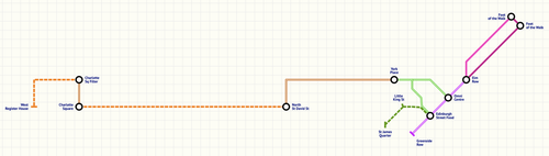
Now, who do I speak to about royalties?
Posted 7 months ago # -
Maybe Edinburgh’s loss was London’s gain…
“
Nobody should be put off by Parker’s development proposals. A major question in cycle campaigning is how best to spend available funds. The centrepiece of Parker’s project is his conviction (which I explain here) that new cycling investment in London will tend to be most impactful when it contributes to a network of signed and mapped cycle routes.
Potentially, Parker’s road map (or something similar to it) could also help cyclists plan journeys. At present, the network is incomplete; so Parker’s road map should not be used as a route planner. However, on the back of sensible decisions being made about the development of Parker’s network, road markings and signs should be positioned on the streets corresponding to his London Cycle Map. The signs and markings would enable cyclists to follow the routes on Parker’s network; in turn, this would enable people to cycle from anywhere to anywhere in the capital by following (in most cases) just a few trails of colour. Obviously, this would be a huge improvement on the present situation, wherein a journey across the capital requires cyclists to remember hundreds of turn rights and turn lefts.
“
https://www.cyclelifestyle.co.uk/blog/road-map-showing-london-cycle-map-routes
Posted 7 months ago # -
Now, who do I speak to about royalties?
Although OCR seems to be one of the things the LLM robot we have at work can't do very well (at least not without errors that they don't notice until they're pointed out), maybe one of them could strip the data out of https://www.innertubemap.com/ to avoid haivng to re-define it all, unless that's the fun bit?
I never go past either end of nor along the Vennel (line 5) without fondly remembering the imaginary network. Similarly I can't go anywhere near Dovecot Road or the Pinkhill path (lines 7R, 22G and 22Y) without wondering where the shops are, or if I'm still allowed to go to the zoo.
Posted 7 months ago #
Reply
You must log in to post.
 posts
posts
