
So, where are we going today?
CityCyclingEdinburgh Forum » General Edinburgh
Cramond to Porty boardwalk/promenade
(197 posts)-
Posted 12 years ago #
-
the WoL path is very dry at the moment, there have been thousands of bikes up and down since Friday. How to avoid the aqueduct?
There should be a way through craiglockhart dell t avoid the aqueduct. There isn't as the valley side very steep but you can do it walking. There is a lovely house down in the valley floor that must be accessed from the craiglockhart side but it might sit on bend in the river on the craiglockhart side. The council used to own a mansion out that way where they ran training sessions. That will be flats now I bet. Not sure why that bit doesn't get used, it is maybe private land but often see deer and is quite a swathe of hidden countryside. Must consult my spokes map.
On north side you can get to the bridge over the Lanark road through longstone park, the new sainsburys has traffic lights that help. On the south side on the actual Lanark road you can access the path via a private road at the crest of the first hill up from slateford.
Posted 12 years ago # -
Seeing as it behaved so well round town today, I'm going to treat my CX to a wee jaunt up Colinton way and into the Pentlands. :D
Posted 12 years ago # -
"So, where are we going today?"
Well we didn't do the sewage works detour...
Posted 12 years ago # -
"There should be a way through craiglockhart dell t avoid the aqueduct."
Think you mean 'There should be a better way through craiglockhart dell t avoid the aqueduct'.
Main problem is the steps by the grotto.
Could be bypassed with a bridge over to the Walled Garden - WAS one (maybe over 100 years ago!)
"The council used to own a mansion out that way where they ran training sessions. That will be flats now I bet."
And a lot more houses were the special schools used to be.
AND no adequate consequential improvement to the path network.
Posted 12 years ago # -
True. I was thinking redhall house which was the training centre but over the river was the walled garden presumably connected but long way down and back for the tatties.
Note that Katesmill Road in craiglockhart which might not be too busy as is a dead end, at the dead end it looks like you should be able to access the path down to the river and from there to colinton and WoL path. Again, steps likely if there is access?
Posted 12 years ago # -
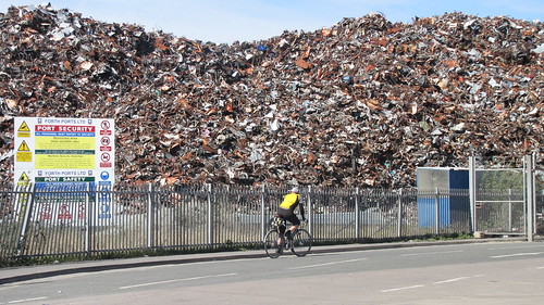
The bit we didn't do yesterday -
http://www.cyclestreets.net/journey/40381618
Because of this -
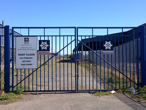
We couldn't get to there directly, partly because of this -
 Posted 12 years ago #
 -
A partial report -
Posted 12 years ago # -
Some thoughts http://deceasedcanine.blogspot.co.uk/2014/04/re-uniting-edinburgh-with-its-coastline.html
Posted 12 years ago # -
"
I grew up in a port city, my mum grew up in a port city, my parents currently live in a port town. And, I always thought that if you live in a port, one of the things you do is drive (or walk or cycle) along the waterfront and check out what is going on -- not just the arrivals and departures of ships, but also the weather, the tideline, the changing skyline. But in Edinburgh, this is not an easy or natural thing to do."
Great perspective/context.
Posted 12 years ago # -
There was some speculation on Saturday about who owned Forth Ports
Turns out it's a London based private company with a range of European transport interests -
http://www.forthports.co.uk/about-us/CSR
http://www.propertyweek.com/5022299.article
http://www.leithermagazine.com/2012/03/09/leith-docks-regeneration-2012.html
Posted 12 years ago # -
Flicking back through the photographs I took during our 'study tour', I was musing on the use of yet more incorrect tactiles. I didn't spot it on the day, and not 'til now, but I was amazed to see that CEC (et al.) did in fact install the central delineator strip on some of the shared segregated paths!
I think this was in the vicinity of Chestnut St/Sealcar St:
(those tactiles are for guidance paths, btw).
Posted 12 years ago # -
Good to see the correct tactiles...but then my eyes were drawn to the strangest bicycle I've ever seen, er, drawn! My 4 y.o. daughter can do better than that...
Posted 12 years ago # -
It is the push-me, pull-you of bicycles.
Posted 12 years ago # -
Is that a clever way to indicate that that side is two-way for bicycles?
Posted 12 years ago # -
It is a great party game - challenge folk to a timed sketching exercise and see how many folk can't draw a bicycle without one in front of them.
Fun* for all the family...
Robert
* Fun not guaranteed. May be illegal in some States. Consume responsibly.Posted 12 years ago # -
did in fact install
Actually, looking more closely at my photograph, I'm wondering if I was right the first time. It looks a lot like good old paint, rather than tactiles.
Posted 12 years ago # -
I'm pretty sure it is just extra heavy layering of paint.
Posted 12 years ago # -
"
The city council report, which appears before the development and management sub-committee, states: “It has the potential to improve pedestrian and cycle accessibility along the city’s waterfront as part of the wider coastal path network.”
"
http://www.edinburghnews.scotsman.com/news/river-almond-ferry-service-returns-to-cramond-1-3491648
Posted 11 years ago # -
We did the ride on the 19th of April, definitely worth doing again.
As an 'anniversary' or earlier in NY?
Posted 11 years ago # -
Next ride planned for 26th.
That's a Thursday so probably won't suit many. (There will be other 'visits')
Looking at some 'connections' too, so starting at 5Ways (10:00) and heading west.
This route includes 'impossible' bits (should show up in black) which will be ridden around!
Posted 11 years ago # -
Hmm. Could make that.
The very last bit should be coloured impossible too, unless you know something about the tides that the map doesn't.
Not the eastern breakwater too? It's just about rideable, or at least no less rideable than bits of the Cramond causeway...
Posted 11 years ago # -
True
But it's low tide at lunchtime...
Posted 11 years ago # -
Speaking of lunch, where do we expect to be ~2-3 hours in, you know, for the refuelling stop.
Posted 11 years ago # -
Posted 11 years ago #
-
Edinburgh Waterfront Promenade 2008 plan route -
Posted 11 years ago # -
What's the route home from Musselburgh, and where's the pub stop?
Posted 11 years ago # -
Depends on the weather.
Posted 11 years ago # -
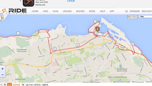
The 'by 2038' plan -
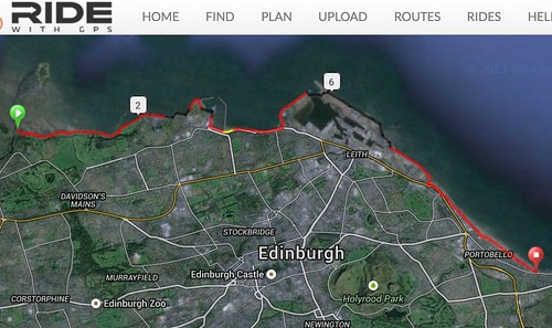
http://ridewithgps.com/routes/7127073
Revised route in LDP -
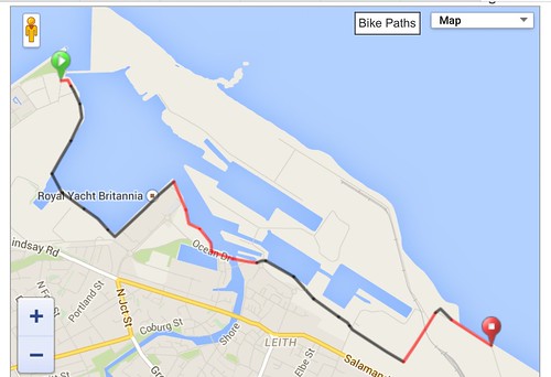
http://ridewithgps.com/routes/7129951
Currently rideable route visiting all accessible sections -
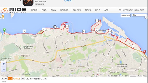
http://ridewithgps.com/routes/7130489
'Family friendly' route avoiding most main roads -
 Posted 11 years ago #

Reply »
You must log in to post.
 posts
posts
