"Beware of cyclists passing at 20mph"
Robert
CityCyclingEdinburgh was launched on the 27th of October 2009 as "an experiment".
IT’S TRUE!
CCE is 17years old!
Well done to ALL posters
It soon became useful and entertaining. There are regular posters, people who add useful info occasionally and plenty more who drop by to watch. That's fine. If you want to add news/comments it's easy to register and become a member.
RULES No personal insults. No swearing.

"Beware of cyclists passing at 20mph"
Robert
It's all right everything is under control.
CEC says -
"
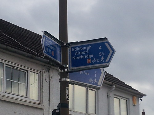
These were put up as part of the route signing we have been undertaking. Unfortunately the contractor put these ones in the wrong place and we are still working with them to pick this up along with the other snagging issues.
"
Another example of contractors installing 'cycle' infrastructure incorrectly.
How many is that now? And how much does that cost us?
Is there a process for striking contractors that are incapable of following instructions off the approved list.
We're still waiting for the signs on route 9 to be fixed. The most difficult (to find) turning on route 9 is still missing - South Gyle Gardens off South Gyle Road. Miss that turning and you'll be lost in the Gyle rather than heading to the Airport.
Me & Greenroofer spent lunchtime today trying to encourage colleagues to cycle to work. We were telling them about the nice quiet route from Roseburn but had to explain that while it is sign posted they still can't be relied on. -
Miss that turning and you'll be lost in the Gyle rather than heading to the Airport.
Probably why I found ~25ish charity cyclists lost and confused in South Gyle industrial estate looking for the bit of path to Cultins Road.
Good news...
It looks like the gaping hole in the route that I noted above has now been closed.
 New sign - now installed by HankChief, on Flickr
I'm still not convinced about the next bit though. South Gyle Gardens is a bit of a wiggly residential street with several paths leading off it. Once you have taken this initial turning, you then need to follow the road round to the left and then left again and then right before you get to the end and the next sign.
To me another sign at the first left turn would avoid the potential for someone heading down the path heading North.
I still think they would have been better going through the park to the North of the David Lloyd club, which would also avoid the awful surface on the North/South path at the West side of Gyle park. I don't imagine that it will be resurfaced anytime soon.
Other good news is that we no longer have to dismount to cross Glasgow Road.
 No need to dismount by HankChief, on Flickr
Previously it was
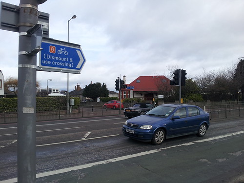 Glasgow Road by HankChief, on Flickr
I don't know if that is all the remediation work done now or not... Let's hope they have fixed the others as well.
I was telling Boyfriend about all this and he reckoned any signs pointing the wrong way could be blamed entirely on Neds...
(this was while we were running along the path round the back of the golf course towards the tram stop at Jenners whatsit. It looks as though they are going to install street lighting along that stretch, which will make it more useful (not that I have ever been on that path before))
(Oh, and I met a confused couple at the Craigleith junction trying to puzzle out the map there. I pointed them in the direction of Leith and remarked that the map was about as much use as a chocolate fireguard...)
Chocolate teapot surely? ;-)
Chocolate fireguard in my vernacular... as useful as a not very useful thing, anyway...
;-)
I did a bit more of the route tonight and they have fixed a few more of the initial errors.
Including the four or five 'where's Carrick Knowe?' signs.
They have even done a proper job of cutting the hedge right back at the Broomhall/Dovecot cut through. Not just a light trimming, but a full blown hatchet job.
So I reckon the signs should now be good enough for someone to follow with guidance.
Anyone going to the Highland Show want to follow route 9 from Roseburn and see if it gets them there?
"
Alan Alexander (@trapprain)
26/07/2014 17:07
.@SRDorman @hank_chief @CyclingEdin @AndrewDBurns This much more sensible imo & both on one pole now.
"

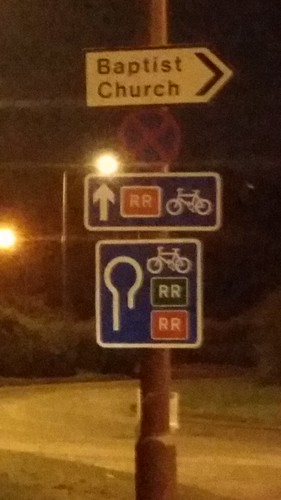
Looks like the random sign writer has been back on business...
Anyone fathom this one out? Heading down from Gillespie Crossroads to the Baberton Bypass access roundabout.
HankChief, on Flickr/]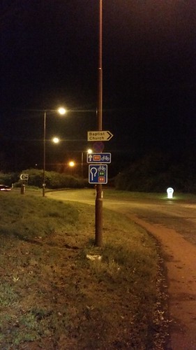 [/url]
Which way? by HankChief, on Flickr
Which way? by HankChief, on Flickr
I go that way quite often, and can't fathom what these are for. The top one seems to be straightforward enough (although I hate the cycle lanes on this roundabout, they put you in the very worst place if you want drivers coming off the bypass to actually see you) but can't work out the second. It seems to be saying go round the roundabout and back up the hill you've just come down. What's it for?
what's the 'RR'?
RR = Ring Road alternative route.
"RR = Ring Road alternative route."
Really? I thought it was Recommended Route (avoiding bypass).
Either way, can't remember if it was signed before or only when cycling on bypass became illegal.
And yes, those signs are ridiculous!
@chdot
You mean there was a time you could cycle on the bypass? Blood and stomach pills!
I cycled on the bypass once, when I was young and foolish. It was a lot quieter in those days and I only went from Dreghorn to Baberton, which is mainly downhill.
Spokes map says RR = Designated "Ring Route", red westbound, green eastbound. If I had to guess I would say the sign is to orientate people coming off the various cycle paths and sections of NCN in that area.
If I remember correctly, part of the bypass, then under construction(?), was used for the 1986 Commonwealth Games cycling road race...
I can very vaguely see the benefit of showing a u - turn for the green (Eastbound) RR if you had been cycling down the hill in the misunderstanding that you could join the Bypass at that point. Seems fairly remote option.
But to show the red (Westbound) RR in 2 directions is just daft.
How do they get through design, approval & installation without being picked up?
Yes, the lower red RR shouldn't be there. How do they get through? I wish we knew the answer to that one. It applies to so much more crap infra than just signs.
I'm having great difficulty finding that 'RR' diagram.
Officially the single 'R' is shown in diagrams 2032 (with a green background) and 2130 (with a white background), for Primary Routes and non-Primary Routes respectively that form part of a ring road. There are references to a "Recommended Route" for cyclists, but the correct diagram for that is no.967, which is the bicycle on a blue rectangular background that we know and love.
" How do they get through? "
Exactly.
Arellcat - I'm assuming its sign 2601.1, with RR being the route number (I know it isn't a number).
That said, I can't find if RR means regional route, ring road or recommended route. It isn't marked on the Sustrans online map or the Council's own cycling maps.
It's always baffled me this one - why would you try and cycle around Edinburgh rather than across it? The RR route wouldn't save you any time and it puts you on some pretty nasty roads with fast moving traffic.
According to the very old sign at it's eastern end it stands for Ring Road:
It does actually for the most part follow the old Edinburgh ring road that existed before the City Bypass opened.
I've occasionally tried to follow this (deliberately using only visible on-street signpostings to test how good they are) when I've had a free few hours (but couldn't go too far out of town in case I got called back) but have always lost the thread somewhere between Oxgangs and Baberton.
It is marked on the cycle street map
http://edinburgh.cyclestreets.net/
OSM has the route mapped, Musselburgh to Gogar Roundabout. Switch to the Cycle Map layer.
http://www.openstreetmap.org/#map=12/55.9110/-3.1888&layers=C
The "random sign writer" of recent times can't really be blamed for a sign which was in place at least as early as 2008 surely? See historic Google Streetview.
I was by chance pondering the fact that the RR route is mapped on OSM (=Cyclestreets) the other day before stumbling upon this particular discussion. There are no exact rules about what should be mapped on OSM - but I'd suggest that a route which only exists in theory in places, which has always been useless, and which nobody would dream of following except out of pure curiosity, should be removed from the map data... at least where signs don't actually exist.
If I could gather some clear intelligence about what actually exists in terms of signage on the ground and what only exists on paper, then I'd be happy to make the edits... (or to encourage others to do so). It would also be possible to raise a bit of a conversation with other OSM mappers to confirm that there is agreement on this before doing anything.
Thoughts welcome.
@rbrtwtmn - Thanks for the correction.
I'm going to put it down to my occasional travels on that route and my involvement on CCE meaning that I'm now honed to spot such idiocies whereas previously I'd have not given it a second glance.
Today I was motorising onto the bypass and wondered if I was allow or not. The sign clearly says "no cyclists". Kind of implies that being a cyclist is a temporary thing rather than a midset and way of life...
Coming back to the recent OT, I do wonder how many people actually use the RR. Does it get counted in a CEC total somewhere? - see other thread. The RR signs are probably used more by people trying to avoid a snarled up bypass.
Going OT again... It does confuse me why Gogar Station Road is coloured blue on the OpenCycleMap used by CycleStreets. I would love for it to have a cycle path/route but sadly it doesn't - see previous thread - may be once they have 'sorted it' it will have one.
You must log in to post.

 Cycling in Edinburgh Flickr group
Video embedded using Easy Video Embed plugin
 posts
posts