CityCyclingEdinburgh Forum » Infrastructure

New route from Canal to Tollcross Open

(26 posts)

  1. chrisfl
    Member

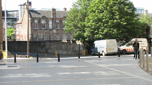
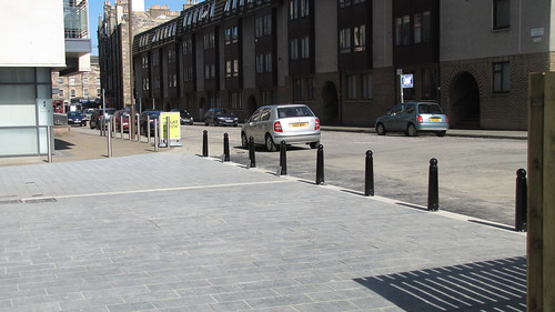
    I've just spotted that a new route has been opened up between the canal and Tollcross. http://www.openstreetmap.org/#map=17/55.94261/-3.20506

    (impressively someone else beat me to adding it to OSM). Nice and wide some plenty of room to cycle. Will add a followup picture in a moment.

    Posted 9 years ago #
  2. chdot
    Admin

    That's the key 'missing link' in the Meadows - Canal route.

    CEC just needs to sort the rest!

    Posted 9 years ago #
  3. SRD
    Moderator

    Consultation on how to join it all up - get cyclists across the road and to the meadows - should start soon. Was funding to actually build it included in this year's budget that we discussed some time back?

    Posted 9 years ago #
  4. kaputnik
    Moderator

    Aye, Kings junction is horrible, but getting in and out of Lochrin Place is no easy matter.

    Posted 9 years ago #
  5. chrisfl
    Member

    Indeed - nice to have the link open some pics here: http://chrisfleming.org/gallery/OSM/Canal-Point

    Posted 9 years ago #
  6. AKen
    Member

    That's the key 'missing link' in the Meadows - Canal route.

    It'll be a clear test to see if the Council has the courage and the ability to do it right - or if they'll just produce a tokenistic cop-out like the Quality Bike Corridor.

    Posted 9 years ago #
  7. ianfieldhouse
    Member

    Until there is some way to easily/safely cross Home Street from Lochrin Place I'll be using Gilmore Place and the crossing there to get to Valleyfield Street.

    Posted 9 years ago #
  8. DdF
    Member

    @srd Was funding to actually build it included in this year's budget that we discussed some time back?

    Funding to build Canal-Meadows-Innocent is 50% from Ed council cycle budget and 50% from their successful application to Sustrans. As in new spokes bulletin and its sustrans supplement.

    Funding to build the new Lochrin Pl to canal link is I'm almost certain from the developers, at the insistence of the council. Spokes and others certainly lobbied and commented about this - it is vital to comment on such planning applications; we try and tell spokes members about the really important ones. e.g. some here.

    Also the link is in the council's Fountainbridge Development Plan (which came out in 2004 I think!!) Again showing the importance of participating in such consultations, even if the outcome takes years to appear!

    Posted 9 years ago #
  9. wingpig
    Member

    Trundled through this yesterday evening. Didn't realise the contractors were officially permanently killing the ability for motor vehicles to get from Lochrin Place to West Tollcross, but it'll quieten the road down a bit. Without going and pressing the pedestrian crossing button I had to wait a couple of minutes to be able to leave Lochrin Place - shifting the crossing a wee bit northwards to cover both corners of Lochrin Place and making it bicycle-diagonal-permitted, a bit like the West Mains Road/Mayfield crossing at the Ashworth Labs corner of KB, but more effective (or perhaps properly advanced-bike-phase) might work, as long as it consistently detected bicycles. I then went up to Valleyfield Terrace, the wrong way along which five cyclists were going in the short time I was there, indicating one-way cyclist-exemption as a possible option for the Meadows-Canal link.

    Posted 9 years ago #
  10. steveo
    Member

    As I remember it that pedestrian crossing is tied to the main junction with Gilmore place and takes ages to turnso even moving it you'd still end up with a long wait.

    Posted 9 years ago #
  11. chdot
    Admin

    "Didn't realise the contractors were officially permanently killing the ability for motor vehicles to get from Lochrin Place to West Tollcross"

    It'll be CEC rather than 'contractors', but I didn't realise either.

    More BOLLARDS!

    (Good)

    Posted 9 years ago #
  12. chdot
    Admin

    New dev has its own (mini) canal!

    Posted 9 years ago #
  13. Kim
    Member

    An attempt to copy Freiburg? If so there is a lot more they could learn from there...

    Posted 9 years ago #
  14. cc
    Member

    The picture above, with the silver Skoda? That line of bollards was blocked by parked cars this morning.
    Otherwise, very nice indeed!
    (The cobbles setts by the canal could still do with being relaid by someone competent though.)

    Posted 9 years ago #
  15. fimm
    Member

    If this is where I think it is, doesn't it lead to some really horrible cobbles/setts between Fountain Court and the canal? If so, I won't be using it.

    Posted 9 years ago #
  16. cc
    Member

    Yes! Here's a map. The new link goes from Lower Gilmore Bank to West Tollcross.

    Posted 9 years ago #
  17. wingpig
    Member

    Some decking, too, if you cross the canal between it and Cargo. Lovely and slippery in the rain.

    Posted 9 years ago #
  18. kaputnik
    Moderator

    Tried it on Friday, the link is very nice and smooth and wide.

    The canalside cobbles are appalling, either they need re-laid or a strip of tar or similar needs created if we are to encourage this as a cycling route.

    Entry / exit from West Tollcross is rubbish too, if you turn left you're into that 3-lane stramash that doesn't allow a turn right towards Melville Drive and making a right turn is very difficult when it's even moderately busy.

    Posted 9 years ago #
  19. chdot
    Admin

    Plenty room for something different, not much point in have two right turning lanes (just encourages traffic flow...)

    Posted 9 years ago #
  20. chdot
    Admin

    Lotsa room round the corner too -

    This could even be shared use -

    Presume the studs are about ownership rather than transport!

    Posted 9 years ago #
  21. kaputnik
    Moderator

    Semple Street and Ponton Street should really get a good segregated salmon run on them as a safe alternative to Lothian Road...

    Posted 9 years ago #
  22. chdot
    Admin

    "safe alternative to Lothian Road"

    Nah, LRd needs done too!

    And this one -

    (Bus and bike only would be good!)

    Posted 9 years ago #
  23. fimm
    Member

    So, is it the connector between West Tollcross and Lower Gilmore Bank?
    (Whatever people posting links to OpenStreetMap think they are showing me, isn't appearing. I'm just seeing a map and guessing.)

    Posted 9 years ago #
  24. cc
    Member

    Yes. The new link goes from Lower Gilmore Bank to West Tollcross.

    Posted 9 years ago #
  25. chdot
    Admin

    "I'm just seeing a map and guessing"

    Sounds good!

    Posted 9 years ago #
  26. chrisfl
    Member

    Yes, it's the link between Lower Gilmore Bank to West Tollcross. Highlighted here. http://www.openstreetmap.org/way/286164903

    Posted 9 years ago #

RSS feed for this topic

Reply

You must log in to post.


Video embedded using Easy Video Embed plugin