CityCyclingEdinburgh Forum » Questions/Support/Help

Consultation on Roseburn section of cycle path to Leith

(63 posts)
  • Started 9 years ago by daisydaisy
  • Latest reply from Rosie
  • This topic is not resolved

No tags yet.


  1. daisydaisy
    Member

    Hi,
    I'm going to a council consultation on the Roseburn section of the Roseburn to Leith cycling and walking route. Do you guys have any thoughts on what you'd like to see happen?
    Here's the info I have so far, will find out more on the day.

    Thanks for being available to attend the design workshop as part of the Roseburn to Leith Walk Cycle Link.

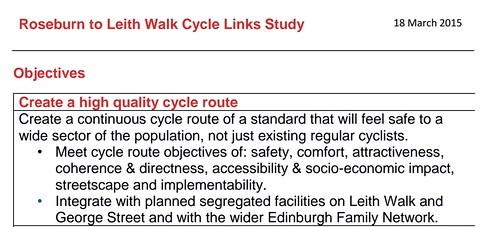
    The Design Workshop will present a range of potential solutions within the route which will be considered and discussed in detail. While the projects main objective is to create a high quality cycle route the project will also aim to improve the pedestrian facilities and enhance the quality of the visual environment of the area.
    The routes that will be reviewed include travelling via either;
    · Roseburn Crescent – Roseburn Place – Roseburn St – Roseburn Terrace – West Coates, or

    · Roseburn Crescent – Roseburn Gardens – Roseburn Terrace – West Coates

    Design objectives have been prepared which outline the principles of the scheme. I have attached a copy for your information prior to the workshop, you will have the opportunity to feedback any comments regarding these at the workshop which will be reviewed along with comments from the previous workshop.

    Posted 9 years ago #
  2. daisydaisy
    Member

    pli=1map of proposed cycle route

    Posted 9 years ago #
  3. daisydaisy
    Member

    Design objectives

    Posted 9 years ago #
  4. stiltskin
    Member

    Six and 2 threes for me. It depends how they cope with the traffic lights at the Roseburn Street junction. Using Roseburn Gardens avoids the exit of Russell Road so I would probably vote for that.

    Posted 9 years ago #
  5. Kim
    Member

    How about we ask for a safe, direct and convenient, which doesn't go round the houses and is designed to encourage people to switch from using cars to active travel?

    Oops sorry forgot this is meant to be part of the "Family Friendly" network designed specifically to make sure that people with children using it strictly for leisure purposes. Therefore they are kept out of the way of far more important people in cars, as families aren't allowed to travel by active means in Edinburgh (at not in the minds of the traffic department).

    Sadly the concept of active travel as way of getting from place to pace and means of everyday transport still isn't accepted by those who are responsible for transport planning in Edinburgh. Therefore they will refuse to do any thing that will give priority to people walking or cycling, over motor traffic.

    Posted 9 years ago #
  6. gembo
    Member

    Is the route intended to link the murrayfield/Roseburn park path to the higher NEPN?

    Quite tricky with kids that.

    I notice the site has been cleared where the bridge takes the NEPN over the road. This had become a campsite?

    Roseburn cliff then down the bike chute follows the river to leith. Using the longer bike chute to get up on to the higher path would be a pain.

    The flats are fair shooting up where they have closed the southern off ramp, where the garage /empty lot used to be

    Posted 9 years ago #
  7. SRD
    Moderator

    I for one am grateful that daisydaisy and others take the time out of their busy schedules to attend these meetings are articulate our demands for safe, direct, and accessible infrastructure.

    If we all feel like Kim does, then we might as well all just all cycle vehicularly or move to Copenhagen.

    I prefer voice to exit or loyalty (hirschman 1970)

    Posted 9 years ago #
  8. ih
    Member

    I'm struggling to understand the objective of this link. The options seem to imply a connection between WoL south of Roseburn and the WoL (or possibly NEPN) north of Roseburn. If so, fine, but Daisydaisy says it is part of the Roseburn Leith Walk cycle link. If the latter, I for one want a direct protected route that goes Roseburn, West Coates, Haymarket, Shandwick Place, through Charlotte Sq, to protected lanes on George St, St Andrew Sq, and a protected route on York Place, Picardy Place and onto Leith Walk. Anything else will not promote a change in commuting mode.

    Posted 9 years ago #
  9. chdot
    Admin

    "I for one am grateful that daisydaisy and others take the time out of their busy schedules to attend these meetings"

    Yes.

    BUT

    Last week there was consultation on G St. to Haymarket.

    There's another on G St. to L Walk.

    THIS IS MADNESS

    Posted 9 years ago #
  10. chdot
    Admin

    Imagine 'consultation' on a new motorway with meetings for the sections between every other Junction!!!

    Posted 9 years ago #
  11. SRD
    Moderator

    It's how they did canal to meadows too. As a series of small consultations. Presume it enables more local focus from residents? And is slightly less intimidating that trying to make sense of the whole project?

    But that is also why it is so important that groups like ours who represent commuters and utility cyclists are also involved, rather than just prioritizing local views - as we've seen with the barnton path debacle.

    Posted 9 years ago #
  12. neddie
    Member

    But chdot, they wouldn't be able to build a motorway through a city without 1000s of consultations...

    Oh wait...

    Glasgow

    Posted 9 years ago #
  13. neddie
    Member

    I can only hope that they'll build all this convoluted family network stuff.

    Then eventually one day someone will say this is a big pile of, and they'll rebuild the whole thing again Dutch style.

    Unfortunately I'll be dead by then.

    Posted 9 years ago #
  14. cc
    Member

    @daisydaisy - thanks. Your two links point to the same little fragment of map for me, so I don't know what the design objectives are. What I think they ought to be is to design a route which will be capacious, smooth and so obviously safe and so convenient that it'll be the easiest and most pleasant way to travel into & out of the city centre for adults and for children, whether in groups or alone - in fact to design a route that will attract a large proportion of the population to use it.

    Also, that blank white strip running roughly north to south in your fragment of map - is that where the Roseburn Path is, unmarked?

    Posted 9 years ago #
  15. wingpig
    Member

    Convolution and complication makes things unattractive. The existing daft wee footway-side bike-path around the corner of Roseburn St/Terrace is useless and unused - something more direct in a more visible location would attract more use. A two-way segregated path along even a short section of the A8 would also be extremely visible to non-cyclists.

    At the previous workshop I tried to cite a few like-this or not-like-that examples from existing local recent nominally-cycle facilities, the better to aid the council cyclebods in attendance which bits they've done work and which bits don't.

    @Kim Within the limited context of the Family Friendly network, further limited by the specific nested scopes of the Roseburn-Leith programme and then the Roseburn fragment, there's still plenty of chance to be helpful about the options on offer.

    Posted 9 years ago #
  16. kaputnik
    Moderator

    I notice the site has been cleared where the bridge takes the NEPN over the road. This had become a campsite?

    No the site has been cleared and the billboards removed so that they can install bigger LED billboards in their place. The trees and foliage might have got in the way from the purpose of the adverts which is distracting passing drivers...

    Posted 9 years ago #
  17. 559
    Member

    Totally supportive of DaisyDaisy and others who are able to attend these consultations.

    However, there is no point in more cycle facilities, that are not used, consider the effect they have.
    Cyclists view them as dangerous or as a long way for a shortcut.
    Motorists view these same underused facilities as a waste of their money.
    Motorists may not be overjoyed initially with cycling infrastructure. But if they see it being used and hopefully reducing vehicle flow, I think they will take a more positive view.
    Consider we are at the stage that if more cycling infrastructure is to be done. The council need to get it much closer to being fit for purpose than they have so far. Good protected facilities, no detours , no dismount signs, no paint defined cycle lanes, no lamp or sign posts intruding on the flow zone.
    Think the suggestions for the routing at Roseburn for this link is convoluted and unduly complicated .

    Complete revamp of the whole Roseburn Street/Roseburn Terrace/Russell Road junction as a complete entity with proper cycle lanes for all routings is essential. The existing arrangement is dangerous and silly for all road users

    Posted 9 years ago #
  18. PS
    Member

    This is just one part of a whole and it's difficult to comment on it without seeing how it fits into the that larger idea.

    Lesley Hinds made some (I thought) very positive comments about the Roseburn to Leith cycling route at last week's Spokes meeting, including that it should be continuous and sections of it should be segregated. In that context, whatever happens on this section should fit smoothly (with as little hold up as possible for the user) into a segregated facility all the way along the A8 to Haymarket.

    Posted 9 years ago #
  19. kaputnik
    Moderator

    However, there is no point in more cycle facilities, that are not used, consider the effect they have.

    Case in point is the existing weird and almost totally unused cycling "facility" to exit Russell Road where you have to mount a pavement from the road on a swift 90-90 degree turn, go round the corner on a surface made up of red paint, cycle across a main road to a central reservation and then try and turn right onto the main road to immediately turn left again into Roseburn Place. And I've no idea what they want you to do on the reverse journey.

    Posted 9 years ago #
  20. Morningsider
    Member

    I have an English translation of the Dutch "Design Manual for Bicycle Traffic" in front of me (not mine I'm afraid - I've only borrowed it). A truly great design document. It is easy to read and understand. The guidance all makes sense - everything seems to happen for a clearly defined reason.

    I think the key thing is that it is all underpinned by a coherent design philosophy - sustainable safety - which influences every aspect of the guidance.

    It defines the main requirements of cycle infrastructure as cohesion, directness, attractiveness, safety and comfort. It then shows how these characteristics can be designed into pretty much any scheme.

    Looking at the little map supplied by daisydaisy - I doubt that this scheme meets most of these criteria. It isn't currently part of a coherent route, certainly isn't direct, is unlikely to be comfortable and unless there is some decent segregation it is unlikely to be that safe.

    The guidance exists, there is cash available, there is at least some political will here - why do we keep ending up with poor quality infrastructure?

    I would be happy with less but higher quality cycle infrastructure, which makes cycling safer and more attractive, rather than miles of advisory lanes or shared use pavements.

    Posted 9 years ago #
  21. chdot
    Admin

    "It's how they did canal to meadows too. As a series of small consultations."

    Yes but (I think) they were consulting on two fairly major chunks which both connected directly to existing infrastructure (both to NMW and individually to Innocent and Canal).

    "Presume it enables more local focus from residents?"

    In theory or practice too?

    "And is slightly less intimidating that trying to make sense of the whole project?"

    So 'people' are too stupid or CEC is trying to be 'helpful' or both(?)

    BUT

    The point is that this is apparently part of the "Roseburn to Leith cycling and walking route".

    Which is both arbitrary and (somewhat) optimistic.

    There is a 'high level' assumption that there are people who want to go from somewhere on Leith Walk to Roseburn (or possibly the NEPN at Roseburn?)

    Seems a bit unlikely though clearly there will be people starting and finishing at various places that coincide with that 'route'/corridor AND joining/turning off to go north/south.

    SO - not only is it important to be able to consider 'the whole route' but also why it was chosen - start/end points and general routing (i.e. incorporating George Street) PLUS how it intersects/connects with other routes (existing and potential - especially, but not only, Sustrans ones).

    Posted 9 years ago #
  22. chdot
    Admin

    CycleStreets is not perfect but it's no surprise that it plots routes via Queen Street (with options using or avoiding Haymarket Yards) -

    http://www.cyclestreets.net/journey/43831098

    A 'forced' route via G St. is similar -

    http://www.cyclestreets.net/journey/43831123

    Posted 9 years ago #
  23. sallyhinch
    Member

    @Morningsider - there's also the Welsh and London design guidelines audit tools which can be used to give a robust assessment of the quality of a route http://www.cycling-embassy.org.uk/blog/2014/10/14/assessing-the-quality-of-cycling-provision-an-audit-tool-for-campaigners

    Posted 9 years ago #
  24. chdot
    Admin

    A (slightly random) route from part way down LW to the Roseburn Viaduct includes part of Queen St (I wouldn't choose to go that way).

    http://www.cyclestreets.net/journey/43831159

    BUT if a route could be plotted at the back of Donaldson's, it would be very different.

    Is there an assumption that this path will never be built??

    Posted 9 years ago #
  25. ih
    Member

    '..though clearly there will be people starting and finishing at various places that coincide with that 'route'/corridor AND joining/turning off to go north/south.'

    Exactly, and this is why it's so important to get this spine right, direct and convenient, so you can join or leave at Broughton St, the Bridges, The Mound, Queensferry Road, Lothian Road, Dalry Road and other key routes. All these routes (and others) should have protected infrastructure.

    Posted 9 years ago #
  26. neddie
    Member

    The Roseburn Street/Roseburn Terrace/Russell Road junction needs to be completely reworked as it is very unfriendly to pedestrians / Tesco Metro customers / pub inebriants.

    If you want to get from the North side of the A8 to the South at that junction you first have to walk 400 yds to another 2-stage ped xing!

    Posted 9 years ago #
  27. kaputnik
    Moderator

    Also Roseburn Place / Gardens is a defacto traffic-light free left turn for vehicles coming from either Roseburn Street or Russell Road and heading west on the A8, turning what should be a fairly quiet side street with a sheltered housing complex, a primary school in the next street and that is a signposted route to a park and cycle route into a busy rat run in the mornings.

    Posted 9 years ago #
  28. chdot
    Admin

    "Also Roseburn Place / Gardens is a defacto traffic-light free left turn for vehicles"

    Indeed!

    Obviously been like that for years too.

    ThisISedinburgh

    Posted 9 years ago #
  29. daisydaisy
    Member

    Thanks for all you comments - a lot to think about. I'll definitely push for segregation on the main A road. And that that road that looks as if it'd be quiet is a rat run.

    Here's the link to the design objectives that I got wrong at the top @Kim 's not going to like it...
    design objectives

    Posted 9 years ago #
  30. chdot
    Admin

    So that's all right then...

    Posted 9 years ago #

RSS feed for this topic

Reply »

You must log in to post.


Video embedded using Easy Video Embed plugin