CityCyclingEdinburgh Forum » Infrastructure

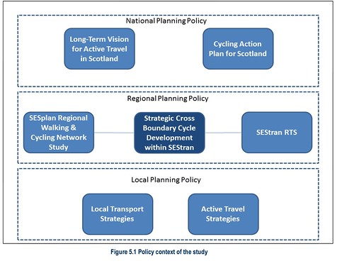
"SEStran Strategic Cross Boundary Cycle Development" (new report)

(19 posts)

No tags yet.


  1. chdot
    Admin

    LOTS in it - still reading!

    "

    SEStran identified the need to develop a strategy for investment covering cross-boundary sections of the cycling network, with particular focus on routes suitable for commuters. Although individual local authorities have responsibility for delivering and maintaining cycling infrastructure within their jurisdiction, greater coordination between councils was thought to be required in order ensure better connectivity along routes that link population and employment centres together across local authority boundaries.

    "

    http://www.sestran.gov.uk/uploads/SEStran_Strategic_Cross_Boundary_Cycle_Development_-_Final_report.pdf

    Posted 9 years ago #
  2. chdot
    Admin

    Previously

    "

    Development of a Strategic Urban Cycle Network

    "

    http://www.sestran.gov.uk/files/SEStran%20Cycle%20investment%20strategy.pdf

    Posted 9 years ago #
  3. chdot
    Admin

    Random

    "

    Musselburgh to Portobello –Summary

    •Key missing link in the network –high quality routes either side

    •Authority –City of Edinburgh Council

    •Current plans -None

    "

    (That's the - mostly wide - road through Joppa)

    Posted 9 years ago #
  4. chdot
    Admin

    I wonder how many politicians/officials have seen this - or agree with it.

    Posted 9 years ago #
  5. chdot
    Admin

    Posted 9 years ago #
  6. earthowned
    Member

    (That's the - mostly wide - road through Joppa)

    With big signs saying "No cycling on footway" after dumping cyclists off the end of Porty prom onto a fast moving road.

    Posted 9 years ago #
  7. chdot
    Admin

    Yep, the very one!

    https://edprom.wordpress.com/places/porty-to-the-esk

    Posted 9 years ago #
  8. Rob
    Member

    Has there been any further development?

    I could really do with this link for a trip to Eskbank tomorrow. I'm not a fan of that section at the best of times but with tomorrow's forecast I may be in the car instead.

    Posted 7 years ago #
  9. Frenchy
    Member

    Has there been any further development?
    Not sure.

    Going from Porty to Eskbank via Gilmerton isn't too bad to cycle. Shared use along the main road out of Gilmerton, and you can take the quiet streets/cycle paths through Niddrie and Moredun to get to Gilmerton.

    Weather's another matter entirely, of course.

    Posted 7 years ago #
  10. Schemieradge
    Member

    "A1 between Tranent and
    Wallyford – full segregation
    an option due to
    carriageway width. Cost
    savings in road surface
    maintenance could help
    pay for this"

    Not sure why this mentions the A1.. surely the A199, but nice to see recognition that there's plenty of room for a segregated lane there, and it's a well used route.

    Currently there's cycle provision in the form of a painted white line which disappears whenever things get even slightly tricky for cyclists.

    Posted 7 years ago #
  11. urchaidh
    Member

    SEStran report on Active Travel Link between Musselburgh and Portobello published.

    Posted 7 years ago #
  12. chdot
    Admin

    "

    We recommend taking forward the proposed B6145 / A199 road corridor route (Option 1) for further consultation and discussion, with recognition that discussions may result in the final preferred route incorporating some section of path realigned to take advantage of the sections of open ground that afford less challenging options for the construction of a ‘coastal’ route.

    "

    http://www.sestran.gov.uk/wp-content/uploads/2017/07/8670_Initial-Report-only_20.07.17_Part1.pdf

    Posted 7 years ago #
  13. Frenchy
    Member

    P38, which I assume has the map of "Option 2: Coastal Route" is blank for me. Anyone able to see it?

    Link: http://www.sestran.gov.uk/wp-content/uploads/2017/07/8670_Initial-Report-only_20.07.17_Part2.pdf

    Posted 7 years ago #
  14. chdot
    Admin

    From part 2

    "

    The feasibility study has concluded that the differences in costs and ease of delivery between the coastal route (Option 2) and the existing road corridor option (Option 1) are such that the coastal path route option will be better explored and developed as a companion, longer-term project. The existing road corridor option is more readily achievable, cheaper and better suited to meet the requirements of Active Travel users.

    "

    Posted 7 years ago #
  15. crowriver
    Member

    The layout detailed in the report seems sensible to me. This is effectively formalising a route that most cyclists use anyway, at least travelling east.

    Hopefully it won't be too long before it's built...

    Posted 7 years ago #
  16. chdot
    Admin

    Cheaper than Sheriffhall.

    (Probably better value too.)

    Posted 7 years ago #
  17. wangi
    Member

    So word I had from inside CEC was even the on-road option wasn't realistically going to happen in the near/mid term...

    It comes in at between £2.3M and £4.0M per mile...

    £80M could get you perhaps 26 miles of cycle path...

    Posted 7 years ago #
  18. crowriver
    Member

    @wangi, it's only £41M on top of existing spend. Not all of that will be capital infrastructure, so...

    I'll be looking forward to riding my electric mobility tricycle along the new route when I'm 102!

    Posted 7 years ago #
  19. crowriver
    Member

    This is interesting. England, from 2011, so factor in inflation and the Scottish construction contractor prices to update costs as per.

    https://transportretort.wordpress.com/2011/02/09/how-much-would-cycle-paths-cost/

    £2.3 million per mile seems about right for "high quality" segregated infrastructure.

    Posted 7 years ago #

RSS feed for this topic

Reply

You must log in to post.


Video embedded using Easy Video Embed plugin