CityCyclingEdinburgh Forum » Questions/Support/Help

water-of-leith questions

(11 posts)
  • Started 8 years ago by SRD
  • Latest reply from kaputnik
  • This topic is not resolved

No tags yet.


  1. SRD
    Moderator

    Apologies in advance for questions already discussed on other threads/in common knowledge:

    1. Anyone know why the water of leith path is closed between Bonnington Bridge and Anderson Place?

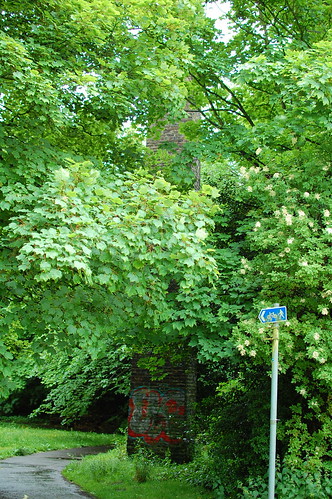
    2. what's the story with the chimney-like structure on the bendy bit near South Fort/west bowling green?

    3. opposite B&Q / warriston the new path makes it much easier to see over the wall into the WoL, which is quite shallow at the moment. it looks like there are stones laid on the bottom of the river; was it once a ford?

    4. what's with the gate-like contraptions along Warriston rd? presume that's part of the new flood-controls? no signage or anything to warn people of road closures.

    5. in the st mark's park/powderhall area, there's a lot of vegetation (nettles etc over the path). There's also something that looks like giant hogweed there by the path and along the river. is it the giant hogweed? or just 'regular'? asking because I heard a disturbing segment on farming today recently about a fisherman who suffered 'life-changing injuries' after getting entangled in giant hogweed. apparently the sap reacts with sunlight and burned him badly enough for him to end up in hospital.

    Posted 8 years ago #
  2. wingpig
    Member

    Loads of hogweed around St Marks general area. Some on my allotment path. After Clarencing last year's outbreaks several times it was eventually sprayed.

    Floodgates. Presumably the operative sent to close them would bring some road closure signs in their van.

    Posted 8 years ago #
  3. Arellcat
    Moderator

    it looks like there are stones laid on the bottom of the river; was it once a ford?

    St Mark's Bridge wasn't built until 1860 or so. Before then, there was a series of stepping stones, latterly positioned just about opposite the access to B&Q. West of there, Warriston Road was just a path, and east of there was just open ground owned by Heriot's Hospital. But at the turn of that century, the stepping stones were located further upstream, at the next bend of the river near where Logie Green Road meets Warriston Road.

    Posted 8 years ago #
  4. I were right about that saddle
    Member

    @SRD

    The Warriston ford is even marked on my favourite map - the Roy Military Survey of the 1750s;

    http://maps.nls.uk/geo/explore/#zoom=15&lat=55.9679&lon=-3.1962&layers=4

    You'll now be lost in 1880s OS maps for the day, but hey-ho it's raining.

    Posted 8 years ago #
  5. Arellcat
    Moderator

    I was at Alpine Bikes today so I went for a poke around. SRD, was this the chimney you were asking about? I found it next to the weir just east of the remaining bit of railway, between Powderhall and Warriston, rather than in the West Bowling Green street area.

    It looks like a chimney but there's no sign of any bricked-up flue connection. That's because it's actually a sewer ventilator. In 1889 Edinburgh built a 12ft diameter sewer that runs from Balerno to Leith, and it more or less follows the Water of Leith. Until about 1960 we didn't have separate systems for toilets/sanitation (the foul sewer) and for rainwater/runoff (storm drains), so everything went into the same pipe. During very heavy rainfall, the 12ft sewer could fill right up and the air would be expelled through vents. The ventilator is still used because the nearby housing is all connected to the combined sewer.

    Posted 8 years ago #
  6. SRD
    Moderator

    Fascinating. We wondered because we couldn't see an obvious bricked up spot either. Would never have guessed it was sewage related. Thanks!

    Posted 8 years ago #
  7. kaputnik
    Moderator

    There's a further ventilator just off Leith Links, marooned behind the fences and walls of the old Roperie site (latterly the Whtye & Mackay blending and bottling plant).

    You can see it on the horizon in this photo;

    In rubble, Industria by andy a, on Flickr

    4. what's with the gate-like contraptions along Warriston rd? presume that's part of the new flood-controls?

    Yes, the gates can be closed during high waters. The houses on Warriston Crescent are protected by the new, high floodwall to their rear, the wall on Warriston Road though is much lower and the river can spill over it. The floodgate keeps it out of everything further downstream. I believe the idea is that Warriston Road between the NEPN bridge at the Lady Haig Poppy Factory and the next gate just after the entrance to the Boat Green flats will be allowed to flood and act as a temporary reservoir.

    Posted 8 years ago #
  8. SRD
    Moderator

    Thanks k'nik. Knew I could count on you guys. Fascinating stuff.

    Wondered why the gates were on both sides - seems pretty extreme as a solution.

    Posted 8 years ago #
  9. Colonies_Chris
    Member

    There are similar gates on the Falshaw Bridge to stop flood waters that overtop the bridge from overflowing into the Stockbridge Colonies or back towards St Bernard's Row. But the water wasn't that high even during the 2001 floods, so hopefully they'll never be needed. And a similar single gate at Veitch's Square (which did get flooded in 2001).

    Posted 8 years ago #
  10. SRD
    Moderator

    Single gates I get. More surprised that they're proposing to flood a built up area on purpose to relieve pressure downstream? Or perhaps just to divert the flooding there? ( since downstream rarely seems to be the problem)

    Posted 8 years ago #
  11. kaputnik
    Moderator

    More surprised that they're proposing to flood a built up area on purpose to relieve pressure downstream?

    I think it's the opposite idea - if you look at the profile of the ground there, they will flood the road and an embankment but the gates will (in theory) hold back the water from the housing. I assume the idea is to provide a temporary reservoir that floods first before the housing.

    If the river ever tops the flood wall though, they're all doomed as the flood wall has the opposite effect and holds the water in the areas of vulnerable housing and prevents it freely draining back into the river when the flood recedes. They found this out when they were building the wall and the river went over the top before it was completed.

    Posted 8 years ago #

RSS feed for this topic

Reply

You must log in to post.


Video embedded using Easy Video Embed plugin