CityCyclingEdinburgh Forum » Infrastructure

GSR - 1,500 Housing Estate - Planning 6th Nov Deadline

(163 posts)

No tags yet.


  1. HankChief
    Member

    Ding ding round 2 (and another long post by me...)

    Murray Estates have put in a planning application for 1,500 houses filling in the plot of land between the Bypass, Gogar Station Road, the A8 and the Edin /Glas railway.

    Multiple views are available on the use of the greenbelt for housing, but as the plans are set out, all the traffic from these houses will be entering and exiting onto Gogar Station Road (GSR).

    There is some good chat in the Transport Appendix 5 about how they will be encouraging non-vehicular transport options...


    Walking and Cycling

    A number of external and internal interventions were identified as part of the Transport Appraisal and these will be incorporated into the indicative development framework
    proposals including the following:

    External
     Retention of and the upgrade to the existing Right of Way which has an access point with the site on Gogar Station Road and the underpass from Edinburgh Park

     Pedestrian/cycle access points on the northern boundary of the site to link in with the National Cycle Network running along the A8 towards Edinburgh and also to the Edinburgh tram halt at RBS Gogarburn, existing bus stops and the planned Edinburgh Gateway where both rail and tram services can be accessed;

     Connections to the existing off road foot/cycle path running under the A720 in the south east corner of the site, providing access to Edinburgh Park Rail and Tram Halts and also the National Cycle Network along the Union Canal;

     Introduction of a new pedestrian/cycle link under the A720 possibly in association with a bus only link;

     Pedestrian/cycle access points in association with the two main vehicle accesses onto Gogar Station Road; and

     The introduction of additional shuttle traffic signals on Gogar Station Road to assist in reducing traffic speeds and improving road safety at locations where this road narrows.

    Internal
     Upgrading of the existing right of way running from the Gogar Station Road to the underpass providing access to Edinburgh Park;

     A core pedestrian / cycle route network running through the site ensuring full permeability;

     Pedestrian/cycle links to the primary school and neighbourhood facilities from the locations throughout the site; and

     Pedestrian links from the various parcels of development to bus stops located along the development core road.

    All sounds good, but I think they are missing (at least) 6 key points.

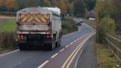
    1. North Section of GSR

    At the North end of GSR it crosses the Gogar burn with a set of traffic lights, which also serve the RBS service yard. This is where the Northern entrance to site will be. They will change the lights to be 4-way (although the application quotes 3 way),

    To the North of here, GSR is only 5.10m wide with a c.1m wide pavement hemmed in by high walls. This will become a key route for a lot of the traffic, including all those residents walking to the Gogarburn Bus & tram stops.

    They are also planning to make the junction between the RBS access road & GSR traffic light controlled, with the only pedestrian crossing on the North leg of GSR.

    I just don't think this area has been thought through for everyone. Particularly pedestrians, but also queuing traffic which could snarl up the whole thing - we already have the occasional problems on this stretch with existing traffic flows.

    Any traffic queues will make it very hard/impossible for cyclists to make progress in line with Movement Hierarchy, prioritising cycling.

    2. Gogar Roundabout

    An access point will be made near to the Gogar Roundabout for Cyclist & Pedestrians to access/exit the North East corner of the site, an onwards to bus, tram & train stops. However, nothing is being done to make crossing the Gogar Roundabout easier for either the A8 Sliproad or the Bypass.

    These are frightening roads to cross, even for fit people and will be a huge barrier to anyone actually using this route to access public transport .

    3. Railway bridge

    At the SouthWestern corner of the site is the narrow Railway bridge on GSR. The approach to the bridge from the North is narrow (5.25m road + c. 1m pavement), with the bridge itself only 3.35m wide and has no usuable pavement for pedestrians to cross.

    A little further South again is the other narrow Gogar Burn bridge which will be getting traffic lights (which is a good thing, as can be scary just now). It also doesn't have a pavement.

    Again, no evidence of how these will be made cycling/walking friendly. The uphill approaches to the railway bridge will be particularly unpleasant with impatient vehicles behind.

    They may use a counter argument that by opening up the access routes to the Southern bypass underpass, cyclists can use that route to access the canal, via Hermiston Gate / Cutlins Road, but that is a much worse route for cycling compared to the wide shared path up GSR over the motorway to the canal on a steady gradient.

    Once it has finished you could go all the way through the new estate towards the Southern underpass, then use the existing railway bridge nearer to the bypass and then rejoin GSR just South of the southern Burn bridge, and up the hill.
    But that is a bit of detour and I assume wouldn't be available during construction.

    4. GSR road itself (between bridges)

    It was a long battle to get the cycle lanes put into GSR and they seem to be working well in slowing traffic down and encouraging wider overtaking. And even then couldn't be put in on the whole length due to width constraints.

    However, their effectiveness will be much reduced if there is the forecasted increase in traffic volumes. From their models, traffic volumes during AM/PM peaks will increase c.50% going with RBS commuters, but possibly more significantly by 100% coming towards you.

    So more overtakes and more likely to face oncoming traffic...

    A lower (enforced) speed limit and/or a separated cycle/shared path is really required here as well as street lighting.

    The pavement is also very narrow so won't be very pleasant with the increased volumes of traffic - including the wide construction traffic.

    5. Parking

    No major employers will be based on the site and therefore, there is not expected to be much demand for car parking other than at the primary school.

    They obviously haven't been round South Gyle on a workday.

    As well as the bypass underpass opening up options for Edinburgh park workers, the current regeneration of RBS Gogarburn will see many more staff trying to get to it with the same car parking. GSR is currently double yellow because it was being used as an overflow car park. Most of the excess parking is currently going to the airport P&R and walking the mile back (or taking the bus), but that would quickly change to a convenient housing estate closer by and increase traffic.

    6. Traffic Flow models

    They have produced some detailed traffic models to show the impact it will have on surrounding roads. I'm no expert on these but it would seem to have undercooked the impact.

    It is assuming that out of the 1,540 properties being built, they would only need to do 1 trip per property, with 80% leaving & 20% arriving during the morning peak.

    And of these trips, only 45% would be as a car driver.

    I'm not convinced by the figures.

    They also have part of their model based on all Northbound GSR traffic turning left(West) onto the A8, whereas in reality they will use the RBS Snowflake bridge to head East towards town. Not sure how much this undermines their findings.

    So in summary, I will be objecting based on these - anything I've missed.

    Posted 8 years ago #
  2. I were right about that saddle
    Member

    Excellent post, HankChief. Anyone who's tried it will know that active travel access to Gogarburn requires some degree of physical courage, especially in winter.

    I'd expect the most alarming phase of this project for GSR users will be the construction one - mud, rubble and HGVs a-go-go. Perhaps the approach to take is through RBS? They have political heft in Edinburgh and take staff well-being seriously.

    Sounds to me like the developer will be making so much money from this piece of land speculation that they'll possibly actually be willing to spend a few spare florins putting in a (lit, gritted?) path link to the canal and the Edinburgh Park/Broomhouse paths.

    I expect that no-one will object to the loss of the chicken factory and its extraordinary aroma.

    Posted 8 years ago #
  3. Greenroofer
    Member

    The transport document is seriously misleading about GSR and the traffic on it. The cynic in me would say this is deliberate, but it could equally be the result of a desk assessment of the road made by a transport planner who's never actually visited the site.

    Anyway...
    # It says that GSR is "a minor road providing access to only the RBS headquarters and a few small businesses", which is true but leaves out the bit that says "and it's used as a rat-run by cars heading from the M8 to Balerno and the A71, and from those points to the airport" (Page 11)
    # It says "major routes surrounding the site (i.e. the A8, A71, A720 and M8) carry large volumes of daily traffic with the volumes decreasing significantly along Gogar Station Road" (Page 11). That's true, a single track country road carries less traffic than the A8 four-lane dual carriageway and the M8 four- or six-lane motorway. I'd never have guessed. It does avoid the question of whether that single track country road is not already carrying an excessive amount of traffic.
    # I agree with HK's assessment of the traffic modelling: one journey per day from only 45% of households is unrealistic. Surely many of these households will be two-person, two-car households, with both going somewhere in the car in the morning (be it to work or to drop the children off at Watsons)
    # It totally doesn't mention how GSR is now a two-way bike route, although the pictures in the report show the road in the process of having the lanes installed.

    My vote for this would be that GSR be closed by a cycle-permeable barrier partway along, so that it's no longer a through route for cars. This would then give a quiet bike route around the edge of the estate and would force traffic to use the trunk roads provided for it.

    Posted 8 years ago #
  4. chdot
    Admin

    "My vote for this would be that GSR be closed by a cycle-permeable barrier partway along"

    +1

    Posted 8 years ago #
  5. HankChief
    Member

    Thanks IWRATS. Hoping that we can get RBS to get involved with this - don't know how much they have considered about the increased traffic going across their bridge.

    You're right that the several years of building work will be the worse as the developers will be wanting to get the first houses built and cash coming in rather than doing the environmental stuff like building cycle paths.

    I'm also not looking forward to the multiple tipper trucks going up and down it. From what I've found on the t'nternet trucks are 2.5m wide excluding wing mirrors, so 2 of them aren't going to pass each other at the narrowest points of GSR (5.1m) without one of them going onto the pavement...Eek...

    It's already quite fun when a big scrap lorry goes along it and meets cars - and that's with those lorry drivers being used to it and generally very considerate (& not being paid per load!)

    Posted 8 years ago #
  6. kaputnik
    Moderator

    One thing to note about GSR is that it's only a "single track country road" at the Gogarburn end, beyond the bridge towards Riccarton it's basically built to A-road standards; wide lanes and very straight. So you can cycle alongside it there on the pavement, that's fine, but what it means is that a fairly large amount of traffic is being funneled down the southern section, at high speeds, then suddenly being condensed beyond the bridge onto the single track twisty section.

    Posted 8 years ago #
  7. I were right about that saddle
    Member

    @Greenroofer

    Your suggestion is most excellent. One HGV-proof bollard placed on the northernmost bridge would blow the cost-benefit calculators' spreadsheets up.

    It would be very intriguing to attempt to pursue this proposal through official channels with grim determination.

    The two points on the road where I have actually feared death are the railway bridge and the southern Gogar burn bridge. They're both funnels and both unaffected by the recent improvements. I wouldn't care to meet a tipper truck in the dark on either.

    Posted 8 years ago #
  8. wingpig
    Member

    "It would be very intriguing to attempt to pursue this proposal through official channels with grim determination."

    Do the developers get to use any existing council traffic count data or would their models be based on their own counts (possibly fiddling it, alongside other usual developer-cheats such as creatively understating expected vehicle speeds when modelling swept paths on access roads)? Would the council, with sufficient nagging, be prepared to stick a couple of those hose things across the road at various points to try and establish the full level of through-route rat-running?

    Presumably extended works on the Gogar roundabout for the Edinburgh Gateway will send a few extra impatient people through GSR. Would there be any intersection of the two periods of work?

    Posted 8 years ago #
  9. HankChief
    Member

    @wingpig you might be on to something...

    So, when we were doing the resurfacing/cycle lane campaign, CEC did a 7 day survey of GSR (starting 19 August 2013) and this showed a AADT (Annual Average Daily Traffic) of 3,111.

    Previously, in May 2013, I did my own survey one weekday morning and counted 350 vehicles & 26 bikes between 8am & 9am.

    To produce the transport assessment, the consultants did their own survey on 23rd June 2015, recording the AM & PM peaks (7-10am & 4-7pm) which showed 396 & 509 vehicles respectively, and they even produced some great diagrams of how many went where (pgs 87 & 88 Appendix 5) and then goes on to model how they will be impacted.

    The interesting part is how they take this data and turn it into an AADT

    "The peak hour traffic flow data obtained from the junction surveys and the data from the strategic ATCs have been used to calculate AADT traffic flows (two-way) for the network of interest."

    [ATCs are Automatic Traffic Counters operated by Transport Scotland so I assume aren't relevant for GSR]

    They came up with 6,201 (pg 133) for the middle part of GSR similar to CEC's and my survey.

    I can't see how the busiest 6 hours of a weekday can have 800 vehicles but the whole day (averaged over 7 days) can have nearly 8 times as many.

    Either I don't understand how AADTs are calculated or something isn't right with their assessment.

    I also can't see how the traffic flow (AADT) will have doubled in the last 2 years, even with the resurfacing. It certainly hasn't felt significantly busier.

    Posted 8 years ago #
  10. HankChief
    Member

    @kaputnik One thing to note about GSR is that it's only a "single track country road" at the Gogarburn end, beyond the bridge towards Riccarton it's basically built to A-road standards; wide lanes and very straight.

    You probably know, but that wide stretch of road was put in when the bypass/M8 was built over the top of the old road. The old road is now the deadend road heading East from southern burn bridge (& takes you to the path heading for the Southern underpass. There is also part of old road heading North from the old Calder road & explains the first bridge over the canal after the bypass as you head out of time.

    You can see both on googlemaps.

    I know we like an old map on here... so here we go.
    http://www.edinphoto.org.uk/1_MAP/1_map_edinburgh_1925_whole_city_2500.htm#map

    None of this makes the Northern section any wider though...

    Posted 8 years ago #
  11. HankChief
    Member

    @IWRATS The two points on the road where I have actually feared death are the railway bridge and the southern Gogar burn bridge. They're both funnels and both unaffected by the recent improvements.

    One concession they are going to make is to put lights onto the Southern Burn Bridge.
    However, with a 50m gap between lights I do wonder if they will leave enough time between green lights to allow the slowest cyclist through, and if they do how much that will causes queues at rush hour.

    And then of course, what about pedestrians.

    Posted 8 years ago #
  12. HankChief
    Member

    I’m not sure a laymen is meant to understand the Transport Appraisals associated with the planning application…

    TL;DR – An earlier Transport Assessment recommends lots of good AT interventions which the current planning application only applies the cheap ones, whilst claiming benefit for them.…

    I’ve done a bit more digging and found that in the original Local Development Plan in 2013, they considered several sites around Edinburgh (but not this one). In the Transport Assessment they considered what could be done to reduce the car usage and encourage ‘sustainable travel’ (everything but car driving or taxis). They start with a base line of 41% sustainable and then identify inventions to increase this under a ‘do minimum’ and ‘do something’ scenarios.

    This site was added for consideration under LDP2 and so a separate Transport Assessment was published in January 2015 and it formed part of the papers used to approve LDP2 at the May Planning Committee. (3rd Background Paper here).

    It starts with 41% sustainable travel and then has a ‘do minimum’ scenario of 43% and ‘do something’ of 55%. The 2 pages interventions required to get to 55%, including these

    ”3 Active Travel
    (f) Measures to ensure safe cycling/walking along Gogar station Road including upgrading existing narrow sections of Gogar Station Road

    5 Road Improvements
    (b) Widen existing road at narrow bridge on Gogar Station South immediately south of RBS site
    (c) Widen existing railway bridge on Gogar Station Road
    (d) Widen existing narrow section of Gogar Station Road near Daltons site
    (e) Upgrade existing east section of Gogar Station Road to link with new south east vehicular access to site”

    These are exactly the interventions we need.

    However, within the planning application we have the following

    “The mode share for the development is based on the “Do something” scenario set out within the Transport Appraisal and summarised in Table 6.1. This scenario assumes that a number of the transport interventions, described within the development proposals in Chapter 2, are delivered.

    Now Table 6.1 has 55% sustainable travel and surprise surprise, the above interventions aren’t listed in chapter 2.

    This is where is now starts to get a bit weird (or maybe just wrong)…

    In Table 6.2 it is shows the number of trips generated split out by mode. In it they aren’t using 55% (despite saying they were) but are using 49.8% cars and 50.2% sustainable – Tram & train are only 1.6% vs 11.1% in Table 6.1 with all other modes proportionally higher.
    I don’t know whether they have used a different figure because they aren’t planning to do all the interventions, but I can’t find any mention in the application that they aren’t using the 45% or that they aren’t doing the interventions.

    There are these mentions of the interventions in Transport Appraisal:


    “2.3.1 Walking and cycling
    The existing pedestrian and cycle networks serving the site are discussed and highlighted in various plans in Chapter 4. In line with the interventions identified in the Transport Appraisal, the following walking and cycling links will be introduced:

    5F
    Walking and Cycling
    A number of external and internal interventions were identified as part of the Transport Appraisal and these will be incorporated into the indicative development framework proposals including the following:

    8.1 Summary
    The East of Millburn Tower Transport Appraisal, prepared as part of the LDP2 process, identifies a number of transport interventions to be delivered as part of the development proposals to support travel by non-car modes of transport.

    8.2 Conclusions
    The East of Millburn Tower Transport Appraisal, prepared as part of the LDP2 process, identifies a number of transport interventions to be delivered as part of the development proposals to support travel by non-car modes of transport.
    [i]

    Also including in the Transport document is some emails from the transport consultant trying which again refer to it.

    [i]” As per the Transport Appraisal, a vehicle driver mode share of 45.0% has been applied to determine two- way vehicle trips during the peak periods (this is in line with the introduction of relevant sustainable interventions as described in the East of Milburn Transport Appraisal).”

    &

    “We propose to address the following within the Transport Assessment:
    • Development of an active travel and public transport strategy which considers the active/public transport interventions required to support the planning application including those identified in the Transport Appraisal;”

    If you are still awake… there was this interesting email reply by a consultant, who I assume works on behalf of the council

    ” I would consider a 45% private vehicle driver mode share to be on the low side for an edge-of-town site such as this and certainly lower than the ‘baseline’ mode shares in the Do-Minimum LDP scenario, and still lower than many of the sites in the Do Something scenario, with the exception of sites directly on the tram line. We would however be prepared to accept the proposed mode share provided it can be demonstrated that the necessary level of sustainable transport measures are being provided.”

    So in summary, it looks like the AT interventions required are known but the expensive ones are quietly being forgotten about…

    Posted 8 years ago #
  13. wingpig
    Member

    Fudgetastic. Charitably, an error in their working which they've carried over.

    "We would however be prepared to accept the proposed mode share provided it can be demonstrated that the necessary level of sustainable transport measures are being provided."

    Hopefully that's been written down somewhere important, like on the checklist of stuff they have to check before rubber-stamping the application. Better still if there were wee sub-check-boxes for all those listed bring-it-up-to-55% items.

    Posted 8 years ago #
  14. HankChief
    Member

    Appreciate that this isn't the most accessible thread for most people but it's a handy place for me to dump my thoughts as I understand it better... Formal objection will be written next week.

    I think I've worked out what was going wrong with the traffic count data I referred to above. The survey of the peak hours took place over 7-10am & 4-7pm but they only used the (one) peak hour within this. So they reckon there is 4-500 movements on the Northern part of GSR in each of the AM & PM Peak hour, which will then roughly double when the development is finished.

    This makes the AADT (Daily Traffic) of 6,200 seem a bit toppy based on a peak hour of 4-500, and is still twice the CEC assessment from 2013.

    What I now can't explain is the AADT modelling, which takes the 6,200 2015 AADT & uplifts it by 10% for organic growth and then only adds 1,900 daily trips (i.e. a 30% increase) from the development.

    Why would the peak hour double but the whole day only up by 30%?

    There is some chat in the Council's TA that the AADT should be calculated using 8.8 trips per privately owned house and 7.2 for rented houses. Which doesn't seem unreasonable to me. You then take this AADT and assume 10% of the trips are in the AM & PM Peak hour.

    It looks like they have shortcut this by saying that 1 trip per household per peak hour, which is about the same as the above.

    However, the AADT modelling seems to be based on only c.4 trips per household, so is seriously understating the traffic impact.

    Anyone know how the Councillors are meant to understand all this to make an appropriate decision?

    Posted 8 years ago #
  15. gembo
    Member

    Councillors will be given a steer by an official on this data. Sometimes they accept the steer other times they do not. Flawed data does not help. Sometimes decisions are made despite good data indicating the opposite of the decision? That sometimes feels like a definition of politics.

    Posted 8 years ago #
  16. HankChief
    Member

    Managed to find that I did get the 2013 CEC traffic survey results after all...

    The 3,111 was the weekday average, with similar peak hour data to the latest survey.

    Just goes to show that the data used is really flawed...

    We're finalising objections from the BUG to get it in by Friday's deadline.

    Just cannot see how anyone can think that an army of tipper trucks on GSR is a sensible idea...

    GSR near Railway Bridge by HankChief, on Flickr

    Posted 8 years ago #
  17. Greenroofer
    Member

    @HK - I can only imagine your inward shout of glee (and perhaps a fist pump) when that truck came past your camera. It's just about the perfect shot to show how narrow the road is and how tipper trucks and cyclists won't mix.

    Posted 8 years ago #
  18. acsimpson
    Member

    Given that shot I'm not sure that tipper trucks and pedestrians on the pavement are compatible either. Quite apart from the serious safety concerns they will also likely cause considerable damage to the new road/pavement surfaces too.

    Posted 8 years ago #
  19. HankChief
    Member

    Okay. Here's the objection submitted on behalf of work's BUG. Deadline is tomorrow (Friday) midnight.

    Objection to Planning Application 15/04318/PPP
    Proposed residential development, local centre (including Class 1, Class 2 and Class 3 uses), community facilities (including primary school and open space), green network, transport links, infrastructure, ancillary development and demolition of buildings. | Land 1000 Metres NW SW And West Of Hermiston Junction M8 Gogar Station Road Edinburgh

    We object to this development as proposed because of its impact on local access and transportation. Specifically, we object because of the road safety issues it creates and because of its impact on cyclists and pedestrians using Gogar Station Road.

    The basis for our objection is the impact that traffic from the development will have on cyclists and pedestrians using Gogar Station Road, which is a key commuter route for cyclists heading between Currie or the Union Canal and RBS Gogarburn, the Airport or Edinburgh Park.

    We have reviewed Revision 006 of the Technical Appendix 5 - Access, Traffic and Transport, and we believe that this document understates the importance of Gogar Station Road as a local through route for motor vehicles and cyclists and therefore gives an overly optimistic impression of the impact of the development on people who use that road.

    Specifically:

    * The report says (p8) "Gogar Station Road varies in width along its length. The prevailing speed limit also varies with the national speed limit applying to the rural part of the road, reducing to 40mph for the more built up parts." This statement seems to conflict with our observations on the road this week: a 40mph speed limit applies along its whole length between the A71 and the A8 except short sections at each end where the speed limit is 30mph. The ‘more built up parts’ of Gogar Station Road make up 2/3 of its length and are winding and narrow, which is why there is a speed limit. In some cases the road is barely 5m wide, which is not wide enough for two lorries to pass without going on the pavement.

    * In the Cycling section on page 9 there is no mention of the significant investment in cycle facilities on Gogar Station Road, implemented in 2015 in recognition of its importance as a commuter route for cyclists. There are on-road cycle lanes on both sides of the road where possible, and an off-road shared-use cycle lane between the Gogar burn south of the site to the Union Canal. However Gogar Station Road is so narrow for much of its length that there is not room for two motor vehicle lanes and two cycle lanes, so the innovative solution is to remove the central white line on the road. In some places, though, the road is so narrow that there isn't even room for cycle lanes. We note that the site maps (Fig 4.3) do not show Gogar Station Road as a local cycle route, which is incorrect.

    * On page 11 the document says "A review of the data in Appendix 5.2 highlights that the major routes surrounding the site (i.e. the A8, A71, A720 and M8) carry large volumes of daily traffic with the volumes decreasing significantly along Gogar Station Road which links to the development site. This is to be expected given that Gogar Station Road is a minor road providing access to only the RBS headquarters and a few small businesses". This does not mention a further factor, which is that the road is a 'rat run' between the M8 and south west Edinburgh, popular in peak periods with vehicles wanting to avoid the city bypass. Any consideration of traffic volumes on Gogar Station Road should bear in mind that in its short length it has four blind corners, three single-lane bridges and several sections less than 5m wide.

    * On page 17, in the section about mitigation of the effects of severance, the document makes no mention of the impact of the development on people travelling by bicycle along Gogar Station Road, which is a key commuter route. The increase in traffic volumes will make this route (which is already challenging due to its width and
    configuration) very hostile for cyclists.

    * On page 19, in the section about Pedestrian amenity, fear and intimidation, the document says “Pedestrian amenity, fear and intimidation are affected by the perceived traffic flow, traffic composition, footway width and its separation away from the carriageway. The levels of traffic generated by the proposed development are relatively low in comparison with the base traffic flows for the majority of links comprising the network of interest. Furthermore, the majority of the predicted increases are below the 30% threshold resulting in an insignificant impact, as previously defined. ". This reference to the ‘base traffic flow for the majority of links’ neglects the impact on Gogar Station Road, where traffic is predicted to double in volume, and in particular where traffic is expected to change from what is essentially a one-directional flow at peak times to a two-directional flow. The pedestrian experience for much of the road at present is on a narrow (1m or less) pavement against a stone wall close to a narrow road that is busy at peak times. This experience will be significantly worse when traffic doubles.

    Our opinion is that the traffic that this development generates will have a significant impact on the experience of cyclists on Gogar Station Road and that more account must be taken of this in the final design.
    We note that cyclist traffic on Gogar Station Road is expected to increase considerably as RBS delivers on its plans to increase the number of staff at its Gogarburn site
    ( http://www.edinburghnews.scotsman.com/news/rbs-to-shut-four-edinburgh-offices-1-3737563 ), and to encourage staff to choose active travel for commuting.

    We also note the previous advice to the Planning Committee (‘East of Millburn Tower Transport Assessment’) about measures to mitigate the impact on Gogar Station Road of this development. We would like to see the following mitigation measures that were recommended in that analysis, but which do not feature in this application be implemented:

    * Widening of the bridge over the railway to allow a usable width of pavement and to accommodate two lanes of traffic, including cycle lanes on both sides

    * Widening of the bridge over the Gogar Burn at the north of the site, widening of the road in that area and incorporation of cycle lanes on both sides of the road.

    * Measures to ensure safe cycling/walking along Gogar Station Road including upgrading existing narrow sections of Gogar Station Road

    We would also like to see the following further mitigation measures that were not mentioned in either assessment:

    * Provision for cycle lanes out of the development at the junctions with Gogar Station Road, including 'Advanced Stop Zones' on all arms of the signal-controlled junctions.

    * Implementation of a 20mph speed limit along the length of Gogar Station Road to recognise that this is a vital link for active travel, but that there are viable alternative routes for motor vehicles.

    * Active steps to discourage vehicles from the development from using Gogar Station Road in preference to the roads within the development. We propose that at the north exit from the site, vehicles should not be allowed to exit south onto Gogar Station Road, nor should they be able to enter the site from the south. At the south junction, vehicles should not be able to exit north or enter from the north. This would have the effect of removing new traffic from some of the narrowest parts of Gogar Station Road, thereby mitigating some of impact of the traffic from the development.

    * Rigorous management of large vehicles during the construction phases. Mindful of the well-known risks that four-axle rigid-body trucks present to cyclists, knowing that in several places Gogar Station Road is so narrow (5m) that two such trucks will not be able to pass without mounting the pavement and that in many places it is so narrow that a truck will not be able to pass a cyclist while leaving the space mandated by the Highway Code, we propose that all construction traffic be required to take the shortest route on Gogar Station Road to and from the site, and that no construction traffic be allowed on the section of Gogar Station Road between the two entrances to the site, and should not use any part of the road during peak periods. Furthermore drivers of any large vehicles using the road during construction should be required to undergo cycle-awareness training.

    Posted 8 years ago #
  20. chdot
    Admin

    "

    Today the phrase garden city has become a euphemism for building in the green belt.

    "

    http://www.theguardian.com/commentisfree/2016/mar/02/healthy-towns-wellness-communities-urban-planning

    Posted 8 years ago #
  21. HankChief
    Member

    A date has been set for the proposals to be considered by the Development Management Sub-Committee (18th April) and they have invited those who commented to speak at the meeting.

    The Gogarburn BUG is taking them up on the offer...

    In other news, the Council's Transport Planning Department's response to the proposals have been published and recommend rejecting the proposals.

    "4. The developer proposals do not fully include the interventions on Gogar Station Road as per the Council’s East of Milburn Tower Appraisal. This is a key cycle route serving the RBS HQ and the Council has recently made provision for improved on-road cycle facilities within the existing restricted road width. With the additional development traffic from this site, road widening or provision of a parallel off-road cycle route (through the centre of the site) is considered essential;"

    Posted 8 years ago #
  22. wingpig
    Member

    Hooray for the feeders-back and the functional ears of the transport planning dept. The Gogarburn BUG appears to have access to the same magic council hotline which EEN frothers accuse SPOKES of using.

    Posted 8 years ago #
  23. chdot
    Admin

    "The Gogarburn BUG appears to have access to the same magic council hotline which EEN frothers accuse SPOKES of using."

    Shhhhh

    It's clearly important that all opportunities are taken to raise 'improvement of walk/cycle facilities'.

    At a basic level officials aren't always aware of possibilities. In things that 'might be contentious' (sometimes aka 'might cost developers money') visible support helps officials trying to argue against other officials.

    Of course whether the Planning Committee should/shouldn't follow the officials is another matter!

    A lot of little things that we may or may not notice are due to Spokes studying many many planning allocations and making comments and (where necessary) objections.

    The person who has done a lot of this over many years went on holiday once. He came back and found that a particular application had been approved without including some provision for cycling.

    When asked, an official said 'we thought it was OK because Spokes hadn't objected'...

    I think there is more aware at CEC these days - at least for small/medium developments.

    Posted 8 years ago #
  24. chdot
    Admin

    http://www.edinburghnews.scotsman.com/news/garden-district-plan-aims-to-restore-gogar-burn-1-4068164

    Contains 'misinformation' about the Gogar Burn.

    Posted 8 years ago #
  25. chdot
    Admin

    "

    Corstorphine Liberal Democrat councillor Paul Edie said controversial plans for major housing developments in the west of the city would mean yet more commuter traffic pouring on to the A8 – which comprises Corstorphine Road, St John’s Road and Glasgow Road.

    "

    http://www.edinburghnews.scotsman.com/news/edinburgh-road-is-the-worst-commute-in-britain-1-4072356

    Posted 8 years ago #
  26. kaputnik
    Moderator

    GSR / A8 path frequenters will be pleased to know that the council has granted RBS planning permission for a new car park with 307 spaces (application 15/05130/FUL) as it seeks to move staff from the closing site on Fettes Row / Dundas Street out to Gogarburn. That's a lot of cars, and a big piece of currently landscaped green land getting used up to provide the capacity for ~3.2 double decker buses

    Posted 8 years ago #
  27. crowriver
    Member

    On the plus side, that's a few hundred daily car journeys removed from the city centre. Swings, roundabouts, etc. Doubtless added to the bypass/A8 congestion, though maybe a few will convert to tram?

    Posted 8 years ago #
  28. ih
    Member

    "On the plus side, that's a few hundred daily car journeys removed from the city centre."

    Depends where those currently driving to Fettes Row drive from.

    Posted 8 years ago #
  29. The Boy
    Member

    And where those who will be living in the flats which will appear on the Fettes Rd site will be driving to...

    Posted 8 years ago #
  30. I were right about that saddle
    Member

    There's much more demand for parking at Gogarburn than there are spaces. The cycle facilities may be gold standard, but only a hard-core use them.

    People actually moan about the walk from tram stop to office and, in one quite hopeless case, about the walk from the furthest car park to the office.

    Posted 8 years ago #

RSS feed for this topic

Reply »

You must log in to post.


Video embedded using Easy Video Embed plugin