CityCyclingEdinburgh Forum » Infrastructure

Roseburn - Canal link (new Dalry route)

(613 posts)
  • Started 8 years ago by MediumDave
  • Latest reply from neddie

  1. MediumDave
    Member

    Hi,

    This dropped through my door last night:

    https://consultationhub.edinburgh.gov.uk/sfc/roseburntounioncanal

    I couldn't find an existing thread to add this post to.

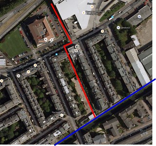
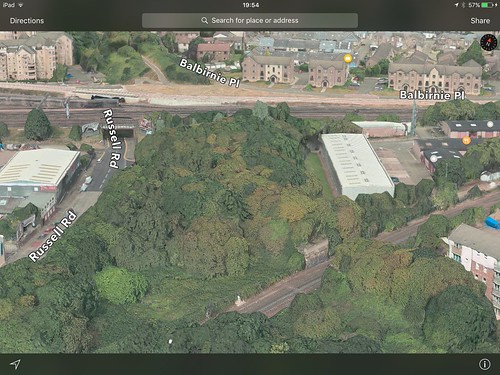
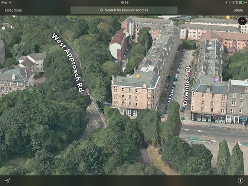
    Though I haven't yet dug into the detail, personally, I like the use of bridges over potentially unpleasant roads. There is however a toucan crossing on the WAR which even so is probably better than the alternative (Telfer subway).

    Posted 8 years ago #
  2. Klaxon
    Member

    Inspiring stuff. Far greater in scope than I would have imagined and oh so nearly brings the NEPN all the way into Haymarket and Fountainbridge without a road crossing.

    Option being developed for a future crossing across the railway at Sauchiebank. New parkland on the dead area next to the west approach road.

    Really really really good.

    Posted 8 years ago #
  3. chdot
    Admin

    "I couldn't find an existing thread to add this post to."

    Have added (new Dalry route) deserves own thread!

    Posted 8 years ago #
  4. 559
    Member

    Excellent, almost,
    Bridge or tunnel to cross the tram and train lines, rather than dropping down to Russell Road then back up again.

    Posted 8 years ago #
  5. chdot
    Admin

    I'm SHOCKED.

    This is SO sensible.

    Check link for a bit of context -

    https://consultationhub.edinburgh.gov.uk/sfc/roseburntounioncanal/supporting_documents/2.%20The%20Current%20Masterplan%20rfs.pdf

    I haven't looked at all other docs, is there one that includes "costs"?

    Obviously there used to be a (railway) bridge from what is now Roseburn Path over all the tracks at Haymarket. (I've walked across it!!) No realistic chance of a new one.

    Hope there are comments about the suitability of calling the proposed replacement bridge the "Mid Calder Crossing".

    Closing the Telfer Subway is an interesting idea. Think it would need much less traffic on WAR to make it 'sensible'.

    If CEC is going to get THIS ambitious I'm sure other things are possible...

    Posted 8 years ago #
  6. Morningsider
    Member

    Now that's an "exemplar cycle project" if I ever saw one. Well done CEC - bite the bullet and bid for community links plus funding for the Edinburgh-Glasgow railway crossing as well.

    Posted 8 years ago #
  7. SRD
    Moderator

    yay, yay, yay!!!

    (anecdote: I was at a meeting recently where it was suggested that the east-west route might be a candidate for 'exemplar' project. i suggested this one instead. maybe i was right?)

    Posted 8 years ago #
  8. cb
    Member

    No realistic chance of a new one.

    It does say:

    "
    Potential future East Coast Main line crossing proposals

    A new elevated crossing over the East Coast Main Line linking between the Roseburn Path and Sauchiebank.

    The crossing will be suitable for pedestrians and cyclists and will be fully enclosed to respond to health and safety issues.
    "

    Don't know why they've put "East Coast Main Line".

    And...

    "
    Potential future West Approach Road Bridge Crossing proposals

    A new elevated crossing over the West Approach Road connecting between the Dalry Community Park and Dundee Street - dependent on potential development.

    The crossing would be suitable for pedestrians and cyclists.
    "

    Posted 8 years ago #
  9. chdot
    Admin

    "Don't know why they've put "East Coast Main Line". "

    Confusing ECML with EGIP(?)

    Posted 8 years ago #
  10. Fountainbridge
    Member

    Seems to me the difficult bit will be a decent tie in with the canal.

    Given Daltons recycling yard seems to be wanting to redevelop their site, I'd like to propose this route

    Untitled-1 by Paul Fountain, on Flickr

    Posted 8 years ago #
  11. neddie
    Member

    Don't know why they've put "East Coast Main Line".

    Because the ECML continues North* out of Edinburgh, across the Bridge and on to Aberdeen, no?

    *Heading in a westerly direction to start with

    Posted 8 years ago #
  12. SRD
    Moderator

    @fountainbridge

    yes, but with access from/to Yeaman place as well...

    Posted 8 years ago #
  13. Klaxon
    Member

    In railway parlance the East Coast Main Line continues all the way to Aberdeen via the Fife coastal route. So they're not wrong, it's just a bit weird calling it that in a public document. Likewise the 'Mid Calder bridge' runs over the Midcalder lines.

    Posted 8 years ago #
  14. davidsonsdave
    Member

    I saw this when I went into the portal to look at the Roseburn to Leith proposals.

    What they are building is tantalisingly close to being great. It seems crazy that they are not also including a bridge to connect directly with Roseburn but if they upgrade the existing bit under the bridge as a temporary measure that would be satisfactory for now.

    However, a plan on how this is going to connect with the canal is something that is essential. I want to be able for my kids to use this route and as it stands, they would be dumped out onto Dundee Street.

    Posted 8 years ago #
  15. chdot
    Admin

    "and on to Aberdeen"

    Hadn't thought about that.

    We all know Wikipedia isn't infallible!

    "

    The East Coast Main Line (ECML) is a 393-mile long (632 km)[2] railway[1] link between London and Edinburgh

    "

    https://en.m.wikipedia.org/wiki/East_Coast_Main_Line

    Posted 8 years ago #
  16. SRD
    Moderator

    "I want to be able for my kids to use this route and as it stands, they would be dumped out onto Dundee Street."

    looks like they are proposing a toucan to cross dundee street which would take you to the new canal access point at the end of Gibson terrace.

    which is not bad

    Posted 8 years ago #
  17. Klaxon
    Member

    Even as proposed it's way, way better than just great. It skips the gauntlet around the Muriestons, makes the path round the back of Lidl useful AND carries it on all the way along the West Approach Road. So many birds with one stone, and no down sides.

    Posted 8 years ago #
  18. steveo
    Member

    Network Rail only class it as going to Edinburgh, they [who] say "is the electrified high speed route linking London and the south east with the Yorkshire & Humber and. North East Regions"

    Posted 8 years ago #
  19. chdot
    Admin

    Don't think route via Daltons is optimum - apart from Yeaman Place to canal cut-through, which a developer might think was a selling point. (CEC could make it a planning condition.)

    A route via Murdoch Terrace would have been best, but that didn't happen whenever they built at the southern end.

    'Best' solution is a 'Buccleuch Street style' bit of segregation to Gibson Terrace - lots of room.

    Posted 8 years ago #
  20. chdot
    Admin

    "AND carries it on all the way along the West Approach Road"

    Yes, and that 'simple' bit could have been done any time in the last 30 years!

    Or at least when this was built -

    http://www.bielski.co.uk/PROJECTS/page7.html

    Posted 8 years ago #
  21. Klaxon
    Member

    The change in vision of the WAR has only changed from 'urban motorway' as recently as a couple of years ago when the Younger Steps were given the nod. Good progress since.

    Posted 8 years ago #
  22. chdot
    Admin

    http://www.edinburgh.gov.uk/directory_record/648803/younger_steps

    That the 'cycle snake'?

    Posted 8 years ago #
  23. kaputnik
    Moderator

    The current Network Rail designation convention for the railway is that of the Strategic Route. Route G encompasses the ECML and some lines in the North East of England and goes only as far as Waverley. The ECML (as far as Waverley) used to have it's own designation as Route 8. The bit north to Aberdeen is strategic route P, formerly Route 24.

    It's in no way wrong to consider the ECML as being either London to Edinburgh or London to Aberdeen, and Network Rail don't think of it in terms of ECML at all, but in terms of Strategic Routes and SRSs. Each Strategic Route is broken down into Sections (SRS), so the border to Edinburgh for instance is section G.11. The SRS at Haymarket where the "missing bridge" is between Roseburn Path and the direction of the canal is section P.01.

    The network specification documents for Scotland can be found here on the NR website;
    http://www.networkrail.co.uk/Network_specification_Scotland.aspx

    Posted 8 years ago #
  24. neddie
    Member

    I don't like the idea of a toucan across 4 lanes of 40mph traffic on the WAR. Seems unsafe to me.

    You can never be sure that all 4 lanes of traffic will stop. You might have 3 lanes of traffic stopped and someone comes flying past in the 'empty' lane. Even worse when you are on a bike - harder to look constantly left & right at all lanes, and take avoiding action if necessary.

    The one further down at Younger's steps is already pretty dodgy.

    Of course, if they 'tamed' the WAR by making it 30mph and reducing to 1 lane in either direction, it might be OK.

    Posted 8 years ago #
  25. chdot
    Admin

    Pretty sure it is 30mph - not that that means that's the actual speed.

    Really should be buses and bikes only, otherwise it just encourages traffic into the city centre.

    Posted 8 years ago #
  26. crowriver
    Member

    Well this is a pleasant surprise.

    So, if this and the East-West link get completed in say the next 5 years or so, we will actually have a cycle route network.

    Still some 'missing links' around though, e.g. Restalrig Path to NEPN. Currently rather unsatisfactory.....do we really have to wait until the Powderhall line eventually closes (which will be when)?

    Posted 8 years ago #
  27. LaidBack
    Member

    Did we not draft out part of this route on another thread? Remember looking at the bridge over railway. Anyway this is an excellent start to improve 'connectivity'.

    Posted 8 years ago #
  28. Stickman
    Member

    Wow! That looks pretty great! The path by the WAR is a surprise bonus.

    Posted 8 years ago #
  29. Fountainbridge
    Member

    Last I heard about the Yeamen place canal connection was in mid 2014. Developer was in conversation (disagreement) about having to supply the connection as part of planning permission.

    Good to see the bridge over Dalry Road, which was originally going to be a toucan.

    CEC original plan for WAR was to block up Dundee street bit and divert slateford bound traffic up through the new road to fountainbridge. WAR would be generally calmed. 40mph speed limit now starts behind Fountainpark.

    Posted 8 years ago #
  30. chdot
    Admin

    As seen in Apple Maps app

    Posted 8 years ago #

RSS feed for this topic

Reply »

You must log in to post.


Video embedded using Easy Video Embed plugin