The CCWEL is also on time for Feb 2024 completion
Glory Be
CityCyclingEdinburgh was launched on the 27th of October 2009 as "an experiment".
IT’S TRUE!
CCE is 17years old!
Well done to ALL posters
It soon became useful and entertaining. There are regular posters, people who add useful info occasionally and plenty more who drop by to watch. That's fine. If you want to add news/comments it's easy to register and become a member.
RULES No personal insults. No swearing.

The CCWEL is also on time for Feb 2024 completion
Glory Be
“
Next spring you'll see progress on the community woodlands and play park
“
Does that mean before/ after path is finished/open?
This is from the start day in January -
“
Construction on the £12.5 million Roseburn to Union Canal Active Travel Route and Greenspace Improvements project will begin today (Monday), when site preparation starts, and is expected to last until April 2024
“
(I thought I’d seen something saying ‘in the summer’, but as I can’t find it, maybe I just imagined it…)
Does anyone know if it’s still planned to replace Telfer Subway with a crossing on the WAR?
If so timescale?
Two bits - end date on the website was projected as July '24 (bottom of that page);
Secondly, why does this project's website have no actual route map? Has anyone ever turned up a complete mapping of it from press releases etc? There's the hodgepodge of individually doodled sections but missing detail.
Reminds me of the too-minimal transit-style CCWEL route map from their website (which was at least something) but to this day I still can't figure out from that / other maps what the route is between Grosvenor Cres and Melville St (I don't often have cause to be in the area!).
It's not explicit, but I think installing that is why the key construction stages page says that the West Approach Road will be closed between Roseburn St and Dundee St in March.
That doesn't make sense though, does it? it says "The section between the Dundee Street flyover and Lothian Road will remain open."
so the area between Roseburn - Dundee St flyover is back before the path end - Telfer.
Previously when the WAR was closed it was because they were doing work along side it / needed to use it to get the construction vehicles in to that big tree covered area that runs alongside the WAR.
page says that the West Approach Road will be closed between Roseburn St and Dundee St in March.
That doesn't make sense though, does it?
No, you're right. Seems more likely the closure is to make it easier to access the area between Lidl and the WAR.
The WAR toucan crossing is still shown on the "More about this project" page.
In other questions -
How’s Canal to Meadows going??
@stiltskin - good point! that is the closure I was discussing above.
@chdot I now expect to be retired before this one simple fix to my commute is finished. at least that way I won't be disappointed.
It so disheartening to see such slow progress. All these ideas, even semi detailed designs, and then… nothing!
What can we do to speed CEC up?
I’d like to get in there and give them all a bloody good shake
it would be good if someone (Spokes?) had a chat with someone at the council to find out what the plans are for the re-opening (or not) of Tarvit street. and if they're working on it in the mean time.
the path between Valleyfield and NMW is terribly over capacity and a mess design wise.
The toucan crossing on the West Approach Road will only require a short road closure for surfacing - there’s no new structures being built on/over the road. Piling is currently ongoing for the bridge over the railway and there’s been a lot of progress on the ramp at the Roseburn side of recent.
Meadows - Canal wise, I know there is a CEC officer currently working on this. Progress has been delayed due to issues with trees on the proposed Valleyfield St - Meadows cycle section. Tarvit Street is unlikely to reopen before early 2025 when the refurbishment is meant to complete. Hopefully things will be lined up so that the CEC contractor can then immediately commence their improvements.
"Hopefully things will be lined up so that the CEC contractor can then immediately commence their improvements."
is this someone's responsibility? this is the bit I wondered about.
thanks for the broader update and info. Good to know someone knows what is going on.
@cyclealex curious about this " Progress has been delayed due to issues with trees on the proposed Valleyfield St - Meadows cycle section"
Isn't the plan to have a crossing from Tarvit and then a protected cycle lane on the Meadows side of Melville Drive up to NMW. [that was what was previously consulted on?]
Under that plan, I can't see where 'Valleyfield-Meadows-trees' come into it.
Does the Roseburn-Canal route just give up at the West Approach Road? Anyone know whether the zig-zag under Cineworld and the weird stepped ramp up to Dundee Street will be improved? Also - how does the scheme actually link to the canal?
I feel the Meadows-canal project is doomed to some kind of eternal limbo. Sparked into life for several months every few years when a keen new officer starts at the Council. Only to be buried again under a toxic sludge of business cases, consultations and grant applications.
There will be a new link structure to take you from the toucan to the top of the zig-zag on the Fountain Park side. No changes to the ramp from this project I believe. The link to the canal will then be built as part of the separate Dundee Street / Fountainbridge project.
@SRD The plan is (potentially was!) to have the new route via Tarvit Street and Brougham Street as well as improving the existing connection via Valleyfield Street. See here: https://consultationhub.edinburgh.gov.uk/sfc/meadows-to-canal-cycling-and-walking-improvements/supporting_documents/MEDCAPHAC01DRC1002%20%20Proposals%20Full%20Extents.pdf
I imagine another issue is also what the current state of the Kings Theatre refurbishment is. I understand they had some financial challenges with the project which might push timescales back.
@cycealex thanks! how had I missed that!
at all the previous consultations, we had been told it was impossible to make any changes there.
*Of course” that drawing/plan is FIVE years old, from this consultation -
https://consultationhub.edinburgh.gov.uk/sfc/meadows-to-canal-cycling-and-walking-improvements/
Presumably no consultations since??
Any ‘final’ decision?
Time for some concerted question asking…
@CycleAlex - many thanks for that, much appreciated.
I find it quite incredible that the Roseburn-canal project doesn't actually connect with the canal. A cycle route is only as good as its worst section. A gap between the canal and the new route will put many people off using it. I appreciate a fix this is being considered as part of another project, but given the timescales involved, the gap may well exist for years.

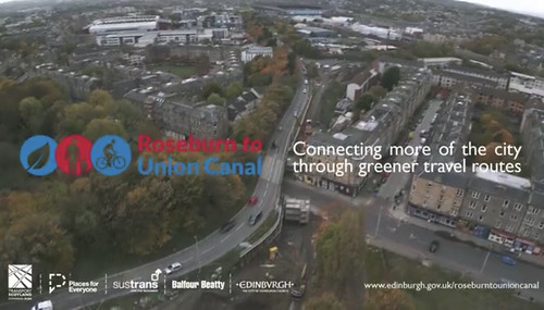
Nice little video
“
A great view of the Roseburn to Union Canal link for walking, wheeling and cycling. It's starting to take shape! Next spring you'll see progress on the community woodlands and play park. Can you spot the new bridge beam over Dalry Road? @SustransScot
“
https://x.com/edinburgh_cc/status/1742540128914972961
Curiously it ends here -

Detail of map done for CEC some years ago.
Missing link’ visible!
It seems odd (well perhaps not…) that CEC is still saying -
“
Construction of the Roseburn to Union Canal scheme is scheduled to be completed in July 2024.
“
But also -
“
The current works will also deliver an at-grade toucan crossing over the West Approach Road at roughly the same location as where the Telfer Subway is located. A new ramp structure will also be provided on the south side of the West Approach Road in order to facilitate the continuous surface level movement of cyclists to the existing ramp/walkway up to Dundee Street.
The onward connection to the canal will ultimately be delivered through a different project named Dundee Street / Fountainbridge. This is not programmed to commence construction until 2026.
“
IN OTHER WORDS
“the Roseburn to Union Canal scheme” - finishing this year - is just a name.
Sadly with CEC’s record, perhaps best not to rely on “2026”
As for ‘Canal to Meadows’, been waiting more than TEN YEARS already.
ADDITIONALLY, today’s news about the Roseburn Corridor just adds uncertainty to the reality of Edinburgh’s ‘off road network’.
“
Roseburn to Union Canal Project Update - January 2024
Welcome to the newsletter for the Roseburn to Union Canal active travel project with information and updates on project activity and planned work.
Dalry Bridge
In November last year, we reached a major milestone in the project with the installation of the bridge beam over Dalry Road. The beam, weighing 64 tonnes, was lifted into position overnight and will form a vital part of this transformative scheme.
Installation of bridge beam over Dalry Road Deck and support structure going in
Russell Road
The first section of the cycleway and footpath is now in use on Russell Road providing a better connection to the North Edinburgh Path Network.
Mid Calder Bridge
Preparations for the new Mid Calder Bridge over the railway are underway.
· Work is due to start on the bridge abutments.
· Construction of the steps and ramp access at Duff Street Lane is due to start soon.
· Foundation work on the Mid Calder embankment (90 piles in total) is now complete.
Dalry Community Park
Work is continuing with the new play park at Dalry Community Park. Following site clearance, the retaining walls are now in place. In the coming months, we will build a new play area with sports pitch, seating, lighting and pathway linking to other parts of the route at Duff Street and Sauchiebank.
Sauchiebank – landscaping and woodland
image012.jpgWork on the retaining walls is mostly complete. We are now looking at the soil condition in preparation for the new woodland community garden which will be built here.
Plans for landscaping and woodland are taking shape. We will plant around 5000 woodland and semi-mature trees along the route. These will combine with areas of native wildflower meadows to increase the area’s biodiversity.
Plants will be chosen to meet the various demands of the site, the varying seasons and be structured to respond to shelter and microclimate issues.
Timeline
· January 2024 - piling works completed for Mid Calder Bridge
· February 2024 - start earth reinforcement and retaining structures to both bridges
· February 2024 – start soft landscaping
· March 2024 – install Mid Calder bridge over railway
· April 2024 – start hard landscaping
· July 2024 - project complete
Community engagement
As part of the Social Impact Plan for the project, Balfour Beatty are engaging with the community in a number of different ways including:
· engineering workshops with local primary schools at Dalry and Roseburn, with more planned.
· working with a social enterprise company, Social Print and Copy, to produce signage on site, and looking to include social enterprises in other areas.
· a Pollinator Highway workshop at Tynecastle High School, bringing together pupils and qualified joiners to dismantle wooden pallets and upcycle them into planters.
The project is also engaging with Gorgie Dalry Community Council to keep the local community up to date and get their input to promoting the history of the area around the new active travel path.
Next steps
We will continue to engage with the Community Council and other community groups to share information on site work and final proposals. A Dalry community workshop is planned for March, which will include site visits. We will design the proposed allotments at Sauchiebank using feedback from recent growing groups.
Keeping you informed
We issue regular project updates to everyone along the route and notify those directly affected by specific construction stages.
You can also keep up to date with progress on our website http://www.edinburgh.gov.uk/roseburntounioncanal
We are working with local schools, community organisations and businesses to look at ideas and options for activities in the area to support active travel.
We are gathering details of community groups who may be interested in working with us for the remainder of the construction project and beyond.
Get in touch
Email: roseburntounioncanal@edinburgh.gov.uk
Good to confirm
As have had the newsletter
But tell me
Where is Mid Calder bridge?
The Mid Calder bridge is (or will be) at the western end of Duff Street Lane. It's the replacement for the long-demolished bridge that carried the Granton Branch over what was the Haymarket Branch (which is now the Dalry/Haymarket end of the West Coast Main Line).
I have never heard it called Mid Calder bridge though. Midcalder Junction for instance is where you'd expect it to be: out in West Lothian and just south of Oakbank and East Calder, before you get to Livingston South.
Has there been any plans to have a cycle path continuing alongside the WAR as far as Morrison Crescent, linking up with the crossing and zig-zag path there then through onto Gilmore Park? Connecting to a Canal to Meadows link at some point...
@boothym wasn't that considered too dangerous?
After getting the email update that others have shared, I emailed back and asked for an update about the toucan crossing.
no reply so far.
> Has there been any plans to have a cycle path continuing alongside the WAR as far as Morrison Crescent, linking up with the crossing and zig-zag path there then through onto Gilmore Park? Connecting to a Canal to Meadows link at some point...
This was definitely included, perhaps aspirationally, in the consultation leaflet from c. 2014(!) I don't really understand why a segregated route would be any more dangerous than the segregated route/pavement that currently runs along it by the existing toucan, or than the existing bus stops by Fountain Park.
(To be clear, the route that was included there was on the verge on the other side from Fountain Park.)
You must log in to post.

 Cycling in Edinburgh Flickr group
Video embedded using Easy Video Embed plugin
 posts
posts