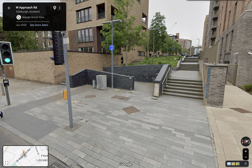
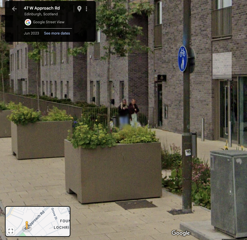
Why are those two railings even there? Are they protecting something?
CityCyclingEdinburgh Forum » Infrastructure
Roseburn - Canal link (new Dalry route)
(835 posts)-
Posted 11 months ago #
-
Were they to protect the patch of concrete the lamppost is set in and haven’t subsequently been removed? Should I pop down and strap them to the side of the cargo bike ;)
Posted 11 months ago # -
@bakky - why not? I'm increasingly convinced Edinburgh's approach to cycle infrastructure development is some kind of absurdist art project. You might as well be a part of it.
Posted 11 months ago # -
Rode this today to get across town for an appointment.
It's definitely a bit twisty turny and rather uneven surface in places (with puddles)but about 100% nicer than Harrison Rd, Murieston etc
and so much faster!
also, roseburn is awfully nice this time of year.
Posted 11 months ago # -
Presume this tiny section isn’t actually shared use.
In spite of all the MILLIONS CEC/Sustrans/SG has spent on cycle infrastructure to/from Roseburn, it really is SHOCKING that CEC is unwilling/unable to remove a few car parking spaces.
Is any of it shared? There are no shared pathway signs between the pictured section and the NEPN zig-zags that I can see. As for that narrow section, there is a shared path sign painted on the pavement just before the crossing to the opposite pavement heading to Roseburn Park. It's orientated such that the shared section presumably starts at the crossing westbound, thereby suggesting that the pictured narrow section is indeed not shared use.
Posted 11 months ago # -
We remarked at the opening that it has removed no parking.
I went out of my way to use it today
It was fab.
Tho I object to the Gorgie Ultras. Grafitti. I vote the perps are found and made to lick it all off
Posted 11 months ago # -
“There are no shared pathway signs between the pictured section and the NEPN zig-zags”
Some/all is segregated.
I think there used to be signs on one or more lampposts, and almost certainly on the walking and cycling surfaces.
Posted 11 months ago # -
“Gorgie Ultras. Grafitti”
‘Missed’ that
Must have been going too fast on my ‘new’ bike
Posted 11 months ago # -
It is plastered all over the walls from Russell road all the away up the new route and even on the bridge. Recent .
Posted 11 months ago # -
Nope, going back 17 years can’t see any signs, just the brick separators in the middle of the path.
Posted 11 months ago # -
I’d forgotten that the ‘extra’ zigzags was as the tramworks.
In the distant past there was a pram trap and a separate pedal trap.
The latter was removed one night with a hacksaw (not me).
Council welded it back.
Next time when the bit of metal was removed, it ended up in the WoL (allegedly).
Posted 11 months ago # -
I’d forgotten that the ‘extra’ zigzag was as a result of the tramworks.
In the distant past there was a pram trap and a separate pedal trap (at the bottom).
The latter was removed one night with a hacksaw (not me).
Council welded it back.
Next time when the bit of metal was removed, it ended up in the WoL (allegedly).
Posted 11 months ago # -
“Recent”
After Sat am perhaps.
Posted 11 months ago # -
@srd - I think sent photos
Posted 11 months ago # -
Ultras graffiti was there Saturday back of one when I passed by.
Posted 11 months ago # -
Why are those two railings even there? Are they protecting something?
I also passed this way yesterday afternoon on my regular commuting bike - I'm pretty sure I wouldn't manage to get past those extra railings on the cargo bike - not without hitting the step.
Posted 11 months ago # -
I haven't cycled the route yet but now I see the step. It does need to be more visible, or better, cut back to a curve and with a ramped kerb. A case of putting in brand new infra but not fully appreciating or fixing its impact on existing infra.
In the torpedo I could use all the newly built infra, except I can't access it: the machine will ground itself on the ramped stairs at Dundee St. And using the WAR would be hazardous enough trying to reach the ped crossing, if it weren't actually illegal; and anyway, you can't turn right off the WAR to Drysdale St reach Fountainbridge.
Posted 11 months ago # -
@arellcat I was maybe in wrong gear but those ramped steps were tough into wind yesterday on standard bicycle
Posted 11 months ago # -
@gembo - the ramped steps are quite fun to go down on the Bomber (140mm travel front forked MTB), rather less joyous to go up on my Gazelle city bike.
Posted 11 months ago # -
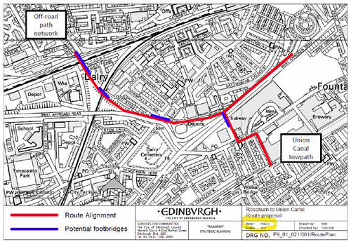
@Arellcat I recall some chat from Spokes that a leg down the northern edge of the WAR towards Morrison Link was originally on the table, and is still considered a potential extension... it's a shame that the crossing further down up to the side of McEwan Sq has zig-zag ramps also unsuitable for longer / specialised cycles otherwise this would have been a no-brainer as the extension up to the canal rather than via Dundee St ramps and Gibson Ter, especially as I'd imagine they'd be reticent to add another toucan for access across to Drysdale Rd.
Posted 11 months ago # -
...have also just clocked that southern edge of WAR between McEwan Sq steps/ramps and Drysdale Rd is shared use. Would be a bit rubbish doubling back so far, but...
Posted 11 months ago # -
@bakky the zig zag a a fair bit down the WAR from the Roseburn toCanal end point.
?
Posted 11 months ago # -
Not far as the bike flies.
Should have been done YEARS ago (perhaps DECADES).
Posted 11 months ago # -
Meanwhile in Kirkcaldy -
 Posted 11 months ago #
 -
@gembo see original route plan from 2014 - had a leg from the new WAR toucan heading north east to the crossing at zig zag
‘Extension to Morrison Crescent’ - and map - via http://www.spokes.org.uk/2024/12/roseburn-to-almost-canal-opens/
Posted 11 months ago # -
You shouldn't need to go all the way to Morrison and double back, there are already lights at Drysdale rd so just extend that to the eastbound carriageway...
Posted 11 months ago # -
@bakky - good to see that - maybe they will finish at least the shorter route then
Posted 11 months ago # -
@Dave - yes, that just seems unlikely (a third crossing in a fairly short stretch?). I agree though.
I suppose it’s possible they try and improve the Dundee St ramps… just struggling to see what would be practical. Just evening them out?
Posted 11 months ago # -
A single long ramp would remove the change in angles, but the ramped steps are the way they are to accommodate people in wheelchairs. They are probably at the maximum permissible gradient. You need multiple shallow sections to allow people to recover after pushing up each step, hence the long ramped overbridges at railway stations these days.
Posted 11 months ago #
Reply »
You must log in to post.


 posts
posts
