CityCyclingEdinburgh Forum » Infrastructure

International Business Gateway - Planning Proposal

(25 posts)

  1. HankChief
    Member

    "

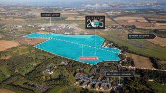
    Developers have lodged outline plans for an International Business Gateway on 90 acres of fields and scrubland next to Edinburgh Airport, stretching from the RBS headquarters at Gogarburn to the Royal Highland Showground at Ingliston.

    "
    http://www.edinburghnews.scotsman.com/news/edinburgh-airport-business-park-plans-lodged-1-3972165

    -------

    We're being overloaded with developments and consultations just now...although we have until 8th Jan to comment for this one.

    Planning Application

    Quick skim through the transport doc, has lots of detail about having a relatively small number of car parking spaces (678 for 6,481 e'ees), which looks positive.

    For cycling they have this comment...

    "A8 NORTH PEDESTRIAN/CYCLE ACCESSIBILITY
    5.5.32 In addition to the mitigation works considered within the micro-simulation modelling of the study network, measures have been developed to increase the pedestrian and cyclist accessibility of the West Edinburgh Transport Study area. Through the detailed review of existing sustainable transport infrastructure, it has been identified that there is a ‘missing link’ along the A8 which is considered to hinder these sustainable modes. A new conceptual pedestrian footway/cycleway route has been developed on the north side of the A8, linking from the existing footway/cycleway at the RBS junction through to the IBG site. The layout is shown in Appendix D."

    (My bold)

    Sadly I can't see an appendix D to see the detail of what they had in mind - It'll be interesting how they deal with crossing the airport dumbbells & connecting to the RBS corkscrew. On the plus side they do talk about £0.5-0.7m for the path.

    They also have plans for improving throughput to Newbridge & Gogar/Maybury junctions and dualling Eastfield Road.

    Need to understand the changes to Gogar RAB - couldn't see anything about making it easier to any off the legs - which we should push for...

    May need closer reading over the festivities...

    Posted 8 years ago #
  2. kaputnik
    Moderator

    Is there a form I can fill out to object to the stupidly vacuous name of the development?

    Posted 8 years ago #
  3. Fountainbridge
    Member

    So they're planning on removing the park and ride site?

    Posted 8 years ago #
  4. Snowy
    Member

    @Fountainbridge Good spot - currently the park&ride takes up about 30% of the buildings in the EEN illustration!

    Posted 8 years ago #
  5. The Boy
    Member

    I believe Phase 2 is planned to be built concurrently so is possible that it will be included in that?

    Posted 8 years ago #
  6. Fountainbridge
    Member

    Had a further skim of the plans and it doesn't seem to state what will happen to the P&R site. Depending which page you look at the P&R site is greyed out, other pages it's fully developed.

    So although the development may have reduced car parking facilities, it could put an extra 1,000 cars back on the road in to the city.

    I also wasn't aware that the tram route between the airport and Newbridge had changed route. I though it ran from the airport west - but now seems it goes from Ingliston P&R west. Previously a Newbridge tram would have called at the airport - but not now

    Posted 8 years ago #
  7. Klaxon
    Member

    Quite a bit on the park and ride in part 3 of the design and access statement. Right at the end is a pair of plans - one retaining the existing extent of the P+R and one with it redeveloped. This paragraph is repeated at least twice.

    Redevelopment of the existing Ingliston Park and Ride facility, owned by City of Edinburgh Council, is part of the wider strategy for the area, described in the West Edinburgh Strategic Design Framework. Although it does not form part of this application, for the purposes of the illustrative masterplan, the Park and Ride has been shown as redeveloped, with a suggested layout that continues the principles of the development parameters.

    "We don't own it, but we're going to plan on the basis you are eventually going to sell us the land"

    Posted 8 years ago #
  8. HankChief
    Member

    They have now put online all the appendices for the West Edinburgh Transport Study, which includes the details of the mitigations they are proposing to do.

    1. Dualing Eastfield Road

    2. Widening the Eastbound exit of Newbridge is 3 lanes from the roundabout to Lochend Road. 1 lane from the M9 slip road & 2 lanes from the Roundabout itself, the outer of which merges into the middle lane just before Lochend Road.

    This will make anyone it interesting for anyone from the roundabout to get into the nearside lane and then turn into Lochend Rd whilst watching out for crossing cycles...

    3. Traffic lights installed for the city bound leg of Gogar Roundabout with 2 lanes at the lights for the underpass and 2 for the roundabout exit slip.

    4. Northside A8 cycle path - Yippee!

    From the plans it is just a simple 3m wide path from the inside of the RBS corkscrew down and across the vehicle exit/entrance to the RBS bridge and across the field and into the SE corner of the new site.

    I will take a look sometime but I not convinced that crossing the sliproads to the RBS bridge (I assume on a unsignalised crossing) will be that good for visibility.

    The across the fields should be okay as will it through the estate. The next challenge will be crossing the southern airport dumbbell, which I imagine will be problematic - Couldn't see any details for how that would happen.

    Posted 8 years ago #
  9. Fountainbridge
    Member

    Cheers Kalxon

    Hankchief - do you have a link to transport study?

    Posted 8 years ago #
  10. HankChief
    Member

    @fountainbridge They have added 3 new files to the bottom of the list of documents.

    The mitigation plans as Appendix D

    linkeee

    Posted 8 years ago #
  11. HankChief
    Member

    Looks like this is coming to Committee next week to get the Masterplan signed off.

    A lot of dense text in the report, but this tweet gives an idea if what to expect.

    It would swallow up the Ingliston Park & Ride, which would need to be moved to Newbridge together with a tram extension...

    Posted 4 years ago #
  12. Snowy
    Member

    I've skimmed the report. One has to admire the careful weasel-wording throughout. It takes many years of professional practice to be this disingenuous.

    They are proposing building 396 domestic dwellings yet have the cheek to say that because this is a small proportion of the overall development, they shouldn't have to provide any 'open green / play space' as is normally required. I'm sure the residents of the aluminium-panelled canyons will be comforted that the developer was treated fairly in this regard.

    I think there's a big risk that they'll end up with a lot of smaller businesses where the employees will seek to jump in cars at lunchtime and head for the Gyle shopping centre. On the plus side, it would link up quite nicely by bike.

    You can play a little game and guess what some of the phrases mean, e.g. "The potential re-meandering of existing watercourses on the site..."

    I love how there's a page on noise mitigation which boils down to "We think double glazing will be a perfectly adequate solution."

    Wonder if there are figures somewhere for how well used that Park&Ride is? Let's face it, no-one is going to pay for a tram extension to Newbridge. They'd have a lot more success putting the Park&Ride next to the Rail Gateway at Gogar.

    Posted 4 years ago #
  13. I were right about that saddle
    Member

    potential re-meandering of existing watercourses

    Could only be written by someone who doesn't know what 'meander' means.

    Posted 4 years ago #
  14. neddie
    Member

    Airport bosses have appealed for councillors to listen to fears that plans for an International Business Gateway (IBG) will “choke access” amid a strategic development plan being redrawn over transport worries.

    https://www.edinburghnews.scotsman.com/news/politics/edinburgh-airport-calls-for-international-business-gateway-plans-to-be-stopped-over-road-fears-1-4937113

    Edinburgh Airport to reject potentially 12,000 new customers?

    Or is it just a smokescreen in the hope they'll get the government to build them a new motorway, straight into the terminal?

    Posted 4 years ago #
  15. Stickman
    Member

    Planning permission in principle approved at full Council today. Vote was 49 - 9 in favour. I’m assuming the Greens and some Edinburgh west councillors voted against.

    Posted 4 years ago #
  16. Stickman
    Member

    https://www.bbc.co.uk/news/uk-scotland-edinburgh-east-fife-48511821

    Planning permission approved, owners flog the land, final development nothing like the approved plans due to *reasons*.

    Posted 4 years ago #
  17. acsimpson
    Member

    "...rivalling Orestad in Copenhagen or in the Zuidas area of Amsterdam."

    I don't know those particular suburbs but as there must be plenty other examples in not such cycling friendly cities I hope they aren't going to screw up the transport links.

    Posted 4 years ago #
  18. Arellcat
    Moderator

    https://www.bbc.co.uk/news/uk-scotland-edinburgh-east-fife-48511821

    "Undoubtedly it's the best development site in Scotland and is strategically important for both Edinburgh and for Scotland."

    «Weasel words alert»

    This means "excellent motor vehicle access to the A8 and the M8/M9".

    Posted 4 years ago #
  19. chdot
    Admin

    So

    Currently fields?

    Green belt?

    Posted 4 years ago #
  20. chdot
    Admin

    “with the public transport infrastructure already in place”

    EG station and tram.

    Adequate?

    Posted 4 years ago #
  21. neddie
    Member

    Let's us not forget that the RBS development at Gogarburn opened the floodgates for developing all this greenbelt land outside the bypass.

    Posted 4 years ago #
  22. Morningsider
    Member

    I've been in Ørestad (in no way related to me getting on the wrong train). It's pretty soulless - think low key London Docklands or pumped-up Quartermile. It is also home to DR (Danish BBC), Denmark's largest mall, a concert hall, university campus etc. - comparisons with the Edinburgh site are massively overblown.

    It is very well connected, with a heavy rail station and six metro stations. It is also just a few minutes by train to Malmo (Sweden). Also - all major roads linking it with the city centre and elsewhere have nice wide uni-directional segregated cycle lanes.

    Posted 4 years ago #
  23. crowriver
    Member

    So, in fact there is no real comparison with Ørestad and this will be more like Edinburgh Park: the sequel?

    Posted 4 years ago #
  24. Saltotom
    Member

    potential re-meandering of existing watercourses

    Could only be written by someone who doesn't know what 'meander' means.

    The Gogar Burn is artificially straightened along that reach. Re-meandering is a way to restore the watercourse to "Good Morphological Status" improving bio-diversity and reducing flood risk. Its probably a big tick for the development.
    The fact it then disappears into a culvert beneath the airport is another matter and there is talk of diverting it around the airport entirely.

    Posted 4 years ago #
  25. chdot
    Admin


RSS feed for this topic

Reply

You must log in to post.


Video embedded using Easy Video Embed plugin