
There is actually another cross pentlands path out beyond the west Calder turn from the A70. Sign posted as west Linton and dolphinton. Starts as a road but not sure what happens after that.
CityCyclingEdinburgh Forum » Leisure
Cross Borders Drove Road
(65 posts)-
Posted 10 years ago #
-
"Starts as a road but not sure what happens after that"
Turns into a bog pretty quickly as I recall.
I just went looking for the route on the map and was puzzled when I couldn't see it, but it looks like the OS have dropped it from their mapping.
My 2004 LandRanger on my phone shows the path going from Crosswood to Mid Crosswood then over Bawdy Knowes before crossing the saddle between White Craig and Darlees Rig. From there it passes the Covenanter's Grave, then on down to Garvald. All, more or less, in a straight line.
I have walked on or near all of it at some point or other. There is nothing visible on the ground so it is all trackless wandering with a bit of ATV track and sheep tracks to follow when suitable.
Always worth checking Geograph for on the ground conditions. Not many contributors for that neck of the woods (me and a couple of others).
Were it not for Geograph (and climbing random very small hills) I probably wouldn't have visited every obscure corner of the Pentlands.Posted 10 years ago # -
"I went by that stanedykehead route at alnwickhill road on Thursday"
It's a good'un, ain't it? Sorry to hear that you are trail-bike phobic. It seems the drove roads were gravel-topped back in the day to protect the hooves of the cattle. No longer. I do think a bit of whinstone and elbowgrease on a few key watersheds would allow a whole new business in Scotland - off-road cycle touring.
Posted 10 years ago # -
@cb from google the road bit doubles back to harperrig via colzium which just gets us Back to original. Of course Google had the whole of the west Linton to little vantage as a path rather than half way on road and half way as bog
Posted 10 years ago # -
I have the 2004 edition of Scottish Hill Tracks if anyone wants a squint before they buy. Pretty reliable so far, but not infallible - route 209 for instance does not exist in any meaningful way once you leave the landrover track in Glen Markie, but you live and learn.
It lists eight crossings of the Pentlands.
Posted 10 years ago # -
The route referred to above has also been ridden by Markus Sitz, as alluded to in the bike packing thread. He formalised a circular route around Edinburgh, the Capital Trail. Maps, etc. here:
http://www.bikepacking.com/routes/bikepacking-scotland-the-capital-trail/
Posted 10 years ago # -
The route that Markus takes is interesting. Uses some old farm tracks above Currie then down to glencorse reservoir then the road to loganlea then back towards Balerno via the waterfall, then over west kip down to nine mile burn which gets us back on track as it were. At the solstice this route should be dry and fairly smooth compared with the drove road routes discussed. It is however quite up and down and roundabout.
Posted 10 years ago # -
I've seen Mr Sitz route, looks pretty cool, though you'd need to be much fitter than I!
The kips are another place that I'd consider no place for a bike. Either up or down you're either pushing or barely controlled not worth it imo.
I think for my first attempt I'll shoot along the WOL, round Harlaw/Thriepmuir, up the tarmac path passed Bavelaw over the moor, round passed West Kip and down passed Eastside farm. The other paths are probably fine on foot or with a very wide tyre but they have a bit too much pentlands swamp to be much fun with luggage.
Posted 10 years ago # -
"
Getting Involved
Tell us about the heritage paths in Scotland that you know. We'd love to receive more route surveys, and please do inform us if you notice changes to paths on this website. Perhaps you have images of paths or features along paths that you'd be happy for us to use. Best of all, simply walk a heritage path and enjoy yourself.
"
Posted 10 years ago # -
On the south side of harperrig on the pAth that connects to the thieves road (the one that goes over the cauld stane slap) there is a place name Baad Park
Posted 10 years ago # -
Never mentioned this road before because the sign says No unauthorised vehicles and directs you east to little vantage or west to harperrig angling club but there is a road from a70 that avoids the bog at little vantage and takes you down to two houses one of which is called Drover's Cottage. One of the properties has a floor to ceiling bathroom window that looks out onto the reservoir. The properties are at the more technical end of the reservoir where water could be run off, I imagine. The road goes to the houses then path to thieves road.
Posted 10 years ago # -
Scottish Hill Tracks Southern Scotland in Oxfam Bookshop Morningside £1.49
Posted 10 years ago # -
I was up that way yesterday, if only I had known. Back next week if I remember. After the orthodontist we went to salt cafe which is so small that the young woman behind me accidentally elbowed me in the kidney and it was sore all day.
Posted 10 years ago # -
Was in today, that copy was either sold or hidden, unless someone has bought for me for my birthday for a surprise?
Posted 10 years ago # -
Took a lot longer to get across the pentlands than I I'd planned. Lying in a field above Romano Bridge 5km shy of where I wanted to be with the last bit done by head torch!
Posted 9 years ago # -
That went well, five hours to tweedbank to find the train cancelled. Is it worth me hanging around for an hour says I, "I don't know, I can't see into the future" says scotrail....
Retreated to the relatively safe harbour of Gala to await rescue.
Posted 9 years ago # -
Steven, scotrail with some sense of humour though that sarcastic priest ended up locked in father jack's dirty underpants hamper
Posted 9 years ago # -
@steveo
Nice one. Care to post the route?
Scotrail, eh? Some machine.
Posted 9 years ago # -
So I may have bit off more than I could chew tbh, actually I’m not sure I think all I really needed was granny ring and functional brakes.
TLDR; the interesting part between Romannobridge and Peebles is fully rideable, if a little steep and soft in places some of the paths are just better mowed sides of a field. Wider tyres, a less aggressive riding position and lower gear would be beneficial, so a hybrid, unless you’re used to riding a CX bike in real off road situations. The downside would be that said narrow (ish) tyres and aggressive position made the joining bits on the road quicker and more enjoyable.
Resume next:
As expected the ride over the top of the Pentlands was a challenge and it took much longer than I expected, the off road climbs were a struggle and without suspension the slight dents in the path were tiring. Coming off the back was pretty steep and quite long, I took a bit of a pounding and had to stop a couple of times for a quick breather. Coupled with some navigational issues meant that I didn’t make up any time from decent. End result, two hours to get from Longstone (WOL path) to the A702.By this stage it was starting to get dark so I abandoned my plans to investigate the Roman Road at Nine Mile Burn and the footpath to West Linton and just get my head down and put in a fast and unpleasant half hour. The detours wouldn’t have added much distance but I was getting pressed for time.
Romannobridge presented a challenge, the path I’d mapped out was a Farmers drive way, it took me twenty minutes to find the access point I wanted in amongst a new build of McMansions. Had I proceeded down the A701 for a few minutes longer it would have been much more obvious. At the trailhead I emptied the Carradice to find my head torch and walked up the grassy hill to find a bivvy spot. Half way up four little orbs were bounding down towards me, I assumed some domestic cats, turned out to be two slightly grumpy badgers, it took a full five minute standoff before they headed back up the trail and off to another field. I found the first flat bit of ground in the lee of a rise in another field and made camp. Bivvy bags are great for these kind of things, five minutes of pottering and I was ready to bed down.
Woke up with a herd of cows watching me crawl out my bag and try to get changed, 20m in one direction a farm house, 50m in another a small estate of McMansions not exactly the wilderness spot I’d wanted for my camp.
Someone mentioned up thread gates, of which there were legion some so close that it barely warranted remounting one to the next. There was nothing very difficult about the next 15km to Peebles it just took over two hours. Navigation was a little tricky there isn’t much on the ground and I’m a bit rubbish at it, so between gates and navigation stops I was stationary quite a lot. Next problem was my general fitness wasn’t there, the rough ground meant I could have done with a lower gear a lot of the time. There were a few bits that were only just rideable so I walked them a bigger bike, moar skilz or being fitter would have made the difference. Finally I seem to have glazed my pads so I was getting next to no function from my front brake and without suspension I was taking another battering so ended up walking a few of descents.From Peebles it was fairly plain sailing as its well sign posted once you find the NCN path. That’s not to say I didn’t miss a turn or two…
What went well: The CDF handled it fine, If I’d been fitter the gearing wouldn’t have been an issue and if I’d replaced my pads before I left then I’d have been able to stop or at least control my decent. The lack of suspension and my lack of fitness meant I took a real battering being a bit tired and spending extended time in an attack position on the off-road descents that probably require a different type of fitness that I’ve not got.
What didn’t go so well: ME! I’ve not been on the bike in anger for about 10 weeks and that lack of conditioning hurt on the climbs and even the flat at the end. I’ve not been off-road in months and that lack of conditioning REALLY hurt!
Not sure I’d rush out to do it again but it was an interesting investigation.
I’d probably head to Stow to get the train turning off NCN 1 at Clovenford rather than schlep all the way to Gala for the train, assuming the drat things are actually running, if the trains aren’t running you’re half an hour closer to rescue in a more interesting village.
First Bit: https://www.strava.com/activities/659626817
Second Bit: https://www.strava.com/activities/659623999Posted 9 years ago # -
Obligatory photos, sorry phone only didn't have room for a proper camera.
Gather dark on the tops.
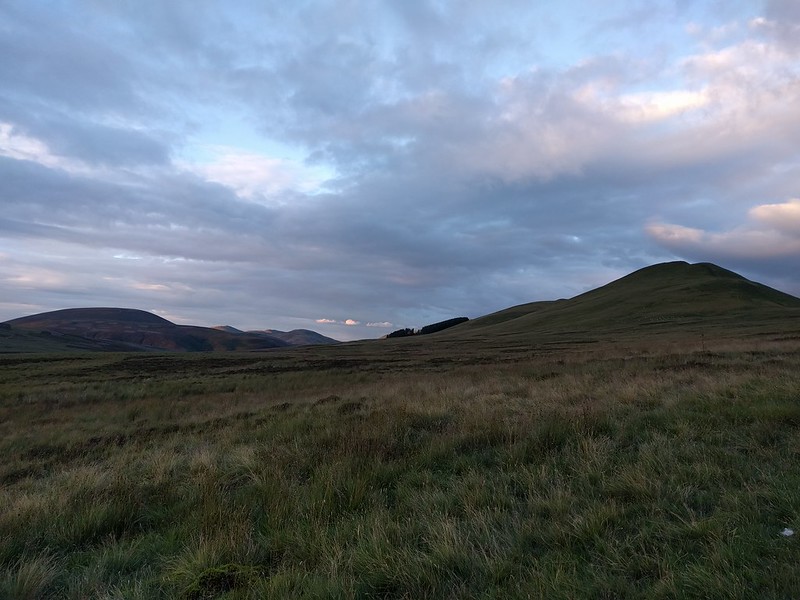 IMG_20160730_204159 by Steven, on Flickr
View from my bivvy bag.
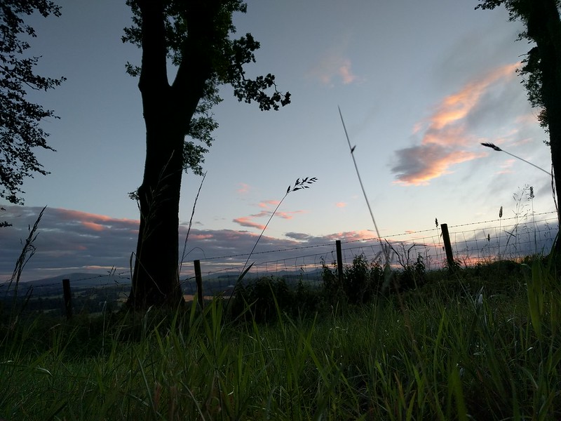 IMG_20160731_052123 by Steven, on Flickr
Camp.
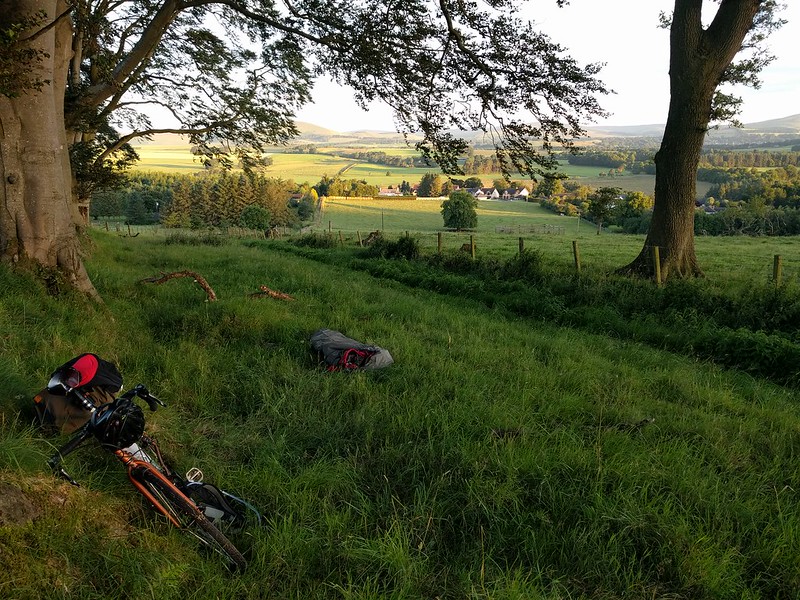 IMG_20160731_055207 by Steven, on Flickr
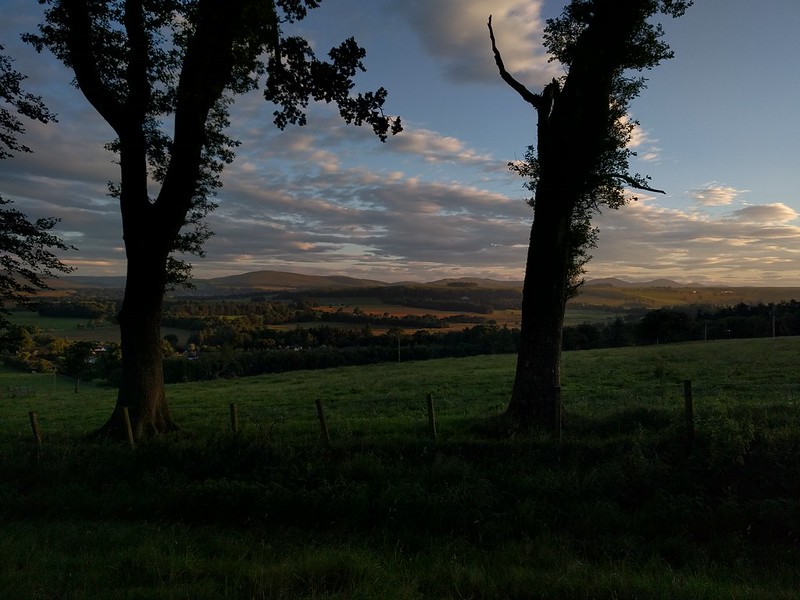 IMG_20160731_055217 by Steven, on Flickr
Click through for full size, I'm on my phone and cba to redo all those links.
Posted 9 years ago # -
Fantastic stuff, @steveo.
If our paths cross at a coffee meet or demo I'll show you the 'Scaffolding Bike' (© @gembo) that I've developed for exactly this kind of riding. It's a hybrid, but not as we know them, more like the offspring of a 29er MTB and a cyclocross bike.
The navigational errors are surely nothing to be worried about. You weren't going to die in this terrain and you've poked about and learned about the area more than if you hadn't got a bit off track.
The grumpy badger standoff is very amusing and the bivvy photos are drawing me into having a go at this area. (Though I'll camp far enough away from the McMansions to get a bit of privacy in the morning...)
Posted 9 years ago # -
Sounds like a better bike for my level of fitness, I presume its got a proper granny gear.
The half hour so wasted navigating were probably the difference between a relaxing ride to where I got to that night and the TT effort I put in on the main road.
Were I going again, and I'm tempted to go have more of a sniff round there now the DOMS have worn off, then that few km to the other side of the pass from Romanobridge would have made all the difference, it was open hill country for a good distance in all directions but it was dark when I got there so opted for bedding down. There is also a couple of hill fort sites marked on the OS map I'd like to have a look round, I was half planning on bivvying down there but had no chance of reaching it in hindsight.
Posted 9 years ago # -
@steveo
From my first coast to coast effort I learned;
1) Low, low gear required. 22/34 on 700c wheels lets you idle up some pretty steep stuff, even lugging 20kg of food and kit.
2) V-brakes are overwhelmed by rough high load descents. Hydraulic disc on the front, hydraulic rim brake on the back. Sorted.
3) Don't worry about 'getting' anywhere. I set an easy pace and sling the tent when, or even better before, I get tired.
Posted 9 years ago # -
Good advice, I'm terrible for the third though. I suspect owing to a general lack of time I always push too hard and set a (unrealistic) goal.
Posted 9 years ago # -
@steveo - thanks a lot for posting this - I reckon I'll be giving this a go on my bike next year at some point.... I think my machine is similar to yours but of lesser quality.... nonetheless I'll give it a go
Posted 9 years ago # -
@algo, no problem. Worth a go, worth taking the detours (the Roman Road at Nine Mile Burn and the footpath to West Linton) off the A702 though. If get a few spare hours one day I'm going to have a look at the surface quality etc.
Posted 9 years ago # -
This looks fun and reminded me of my trip by MTB a couple of years ago from Aviemore to Fort William over the Corrieyairack Pass.
http://citycyclingedinburgh.info/bbpress/topic.php?id=13578
I did this solo and with a rucksac as I wanted a light bike without panniers to allow lifting the bike over styles etc...
If you have any plans to cover this again, or any others give us a heads up, as I'd love to join you.
I took very minimal kit to keep the weight down, and faffage to a minimum. The more stuff you take the more there is to unpack so the longer you spend off the bike.
I had a day sack with water proofs, tent, sleep mat, sleeping bag, thick down jacket (as it was late Sept), stove, water food, spares n repairs for bike. Thats pretty much it.
I know the route you took wasn't part of a trail so not as direct and required a little navigation but it looks good as a ride down and train back up. Did you look up the route the overnight MTB challenge from Portobello took a couple of years ago, run by Markus Stitz?
Posted 9 years ago # -
So. This is shaping up to become the 2017 CCE (trail riders sub-section) outing, isn't it?
I suggest;
1) Defining only the date and bivouac point.
2) Suggesting people make their own way to and from the bivvy by any route and means they choose.That way;
1) There is no leader or organiser.
2) Maximum flexibilitiness.
3) Caters for 'anusol & bubblewrap' and 'fine wine & olive oil' types and all in between.I do like the idea of cycling the actual 'Drove Road' route. The Minch Moor section is steep (I went looking for goshawks a couple of times) but should be rideable with overnight kit on board.
Posted 9 years ago # -
Dave, I've looked at Markus Stitz route when I was doing my initial research, he's waayyyy fitter than me though you'd probably manage that route.
Sounds like a plan iwrats.
I quite fancy the whole drove road too but it would have to be on a mtb, possibly with hybrid tyres of knobblier end of the spectrum. Its something like 120km to Hawick two full days should cover it.
Posted 9 years ago #
Reply »
You must log in to post.
 posts
posts
