
Yes it was dreadful. This is our route with the 7yo going back from the ice rink and with the horrible crossings to get to Russell Road I'm thinking we should revert to the Baird Dr/Pansy Walk detour even though the Westfield junction is also pretty grim. (But basically the takeaway is there is now essentially no family-friendly cycle route between Roseburn/Murrayfield and Gorgie/Dalry and beyond.)
CityCyclingEdinburgh Forum » Infrastructure
Roseburn Park - shared path closed (now open!)
(246 posts)-
Posted 9 years ago #
-
"
Edinburgh Council (@Edinburgh_CC)
26/10/2016, 07:55
Help us make cycling and walking easier in Roseburn Park. Consultation closes 26 Nov #onfootbybikehttps://consultationhub.edinburgh.gov.uk/sfc/design-cycle-walk-roseburn-park
http://pic.twitter.com/8Fzp26nkb1
"
Posted 9 years ago # -
Also this morning, a digger was being reversed along the path - the guy who I assume was supposed to be the banksman was some way back on his phone.
Posted 9 years ago # -
Two large lighting units were apparent when I came through the park the other night. Thankfully lighting is better although it's still dark on the south side of the park. Unfortunately the new narrow and slippery diversion is awful for all concerned, pedestrians and cyclists alike :(
Posted 9 years ago # -
I don't know why they don't build a temporary path like they have on the other side (wider than that one ideally)
Posted 9 years ago # -
Riversdale Crescent is closing again next week.
Initially just by the Doctor's surgery which shouldn't impact park users and then for the Ice Rink bridge which will involve park users to divert to the pedestrian bridge.
I spoke to the contractor - they will close the road and then see what space they have to run a cycle path once the Heras fencing goes up.
They are keen to put one in so will do what they can....
"Riversdale Crescent Road Closure – Junction with Corstorphine Road
The installation of the flood gates on Riversdale Crescent bridges are scheduled to commence in November 2016.
To facilitate these works Riversdale Crescent, from Murrayfield Ice Rink Vehicle Bridge towards Corstorphine Road will be closing from Monday 21st November 2016 through to April 2017.
Local access only will be provided from the west side of Riversdale Crescent for the Chinese Consulate and the apartments at 14b. Please note this will be an access only with no drop off/waiting facility.
Pedestrian and cycle access will remain with a diversion in place to Murrayfield Medical Centre, Riversdale Crescent and Corstorphine Road.
These works will be carried out in 2 phases:
Phase 1 of the works will be to install the flood gates on the pedestrian bridge and the wall between both bridges.
Phase 2 of the works will require a full closure of the Ice Rink vehicle bridge. At this point in time McL&H will provide alternative access to Murrayfield Ice Rink/Murrayfield Curling Rink car parks via Saughtonhall Avenue Bridge. It is anticipated that these works will commence in January 2017.
"
Posted 9 years ago # -
At the Murrayfield Comminity Council meeting this evening the local PC said that taxis had been driving on the pavement in order to get round the current road closure.
Also, a community councillor called for cyclists to be banned from the park. He accepted this may be impractical so would restrict the ban to weekends. Fortunately he was laughed at by everyone.
Posted 9 years ago # -
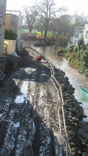
 Roseburn flood defenses by HankChief, on Flickr
Coming out of Murrayfield yesterday, I had chance to see how the flood defences are coming along. Looks like we'll get a nice riverside path
Posted 9 years ago # -
There's a small plot of land up for sale for development on Corstorphine Road, beside the flood works. No doubt the owner is able to ask for a lot more as a result of the new defences. Perhaps IWRATS has a suggestion about how to deal with such gains?
Posted 9 years ago # -
@Stickman
IWRATS suggests a tithe on the oats grown thereon, presented to the baillie of that manor on St Swithin's Day.
Or land value taxation.
Posted 9 years ago # -
Sunday
 Posted 9 years ago #
 -
There's a small plot of land up for sale for development on Corstorphine Road, beside the flood works.
That plot of land has been up for sale for decades.
Presumably they couldn't sell it because of the flood risk.
Posted 9 years ago # -
Ah, didn't know that. The nice new Rettie sign that has been put up suggests they are having a go again.
Posted 9 years ago # -
That recent picture of the Roseburn flood works by Hankchief looks a lot like the L.A. river...
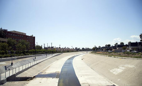 la_river_flipped by Ed, on Flickr
(see http://citycyclingedinburgh.info/bbpress/topic.php?id=16593&page=6&replies=162#post-243587 )
...which ironically they are trying to convert back to a more natural river:
https://www.theguardian.com/cities/2015/oct/23/frank-gehry-revitalise-los-angeles-la-river
Posted 9 years ago # -
Monbiot has written extensively on the lunacy of water run-off management in the UK.
Posted 9 years ago # -
The basic summary is that water is best left to flood low value areas and be released slowly over the following days and weeks than it is to try and direct the peak flow through urban channels that require insane size and engineering (what the LA river tries to do)
The river management downstream of the Oroville Dam (recently in the news) for example is really quite obvious on the overhead maps
> Big high volume diverter canal
> Upper holding reservoir
> Lower, much larger holding reservoir with free flooding area
> Broadly, development kept well back from the river's edge and grade separated (See not only Oroville but Yuba City a little south)
> Area between meanders clearly left to flood as incredibly green and fertile
> Absolutely huge and mostly dry levee canalsAnd never mind the buffer that the 3 stage mountain dam system itself can take up
Posted 9 years ago # -
I miss the old dishevelled wildlife corridor.
There used to be a lake between Corstorphine & Roseburn & you'd travel by boat.
Flood plain building...
Soil in my garden is alluvial - it's very friable.
Posted 9 years ago # -
Another bit of temporary path across the grass, by the buildings. Watch out because it's been badly laid and it is narrow.
Posted 9 years ago # -
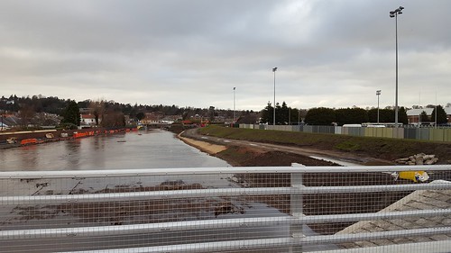
I noticed this evening the WoL path from the ice rink towards Balgreen has been surfaced. Looks like a proper hard sealed surface which is nice: I think the original plans were for compacted gravel.
Posted 9 years ago # -
Is it open?
Posted 9 years ago # -
No - the path looks nearly ready but they are still working on the bridge at Saughtonhall Ave.
Posted 9 years ago # -
Nice to see Roseburn embracing tourism: a couple of Italian motorhomes stopped up overnight in the park.
Posted 9 years ago # -
Friends of Roseburn Park are having their AGM tonight if anyone is interested.
http://www.friendsofroseburnpark.org.uk/2017/08/16/annual-general-meeting-26-september-1930/
Posted 8 years ago # -
@Klaxon
"The basic summary is that water is best left to flood low value areas and be released slowly over the following days and weeks"
The original WoL flood prevention scheme proposals used Roseburn Park for precisely that purpose. My understanding is that the SRU objected because it would flood their practice pitches.
IIRC there was also a plan to build a huge underground holding reservoir beneath Donaldson's school. I've no idea whether that has happened, or will happen. Given the amount of money that's being spent on converting the place into luxury homes - and the amount of money that's no doubt expected to be made by doing so - I rather suspect someone will have objected to that idea too. OTOH, it is good that the place is at last being made use of.
Posted 8 years ago # -
Practice pitches are exactly the sort of land that should be flooded and it’s a shame the SRU got their way
Edinburgh Uni’s eastern playing fields at Peffermill serve this purpose for the Braid Burn now, but I’m not sure if the storage has been used in anger since the levees + walls were built.
Posted 8 years ago # -
In news unrelated to the flood defence work. There are plans for the Ice Rink to be knocked down and replaced by a hotel and the SRU have also given Wanderers RFC notice that they won't be able to lease the back pitches from them as they are looking to develop them as well.
Posted 8 years ago # -
the SRU have also given Wanderers RFC notice that they won't be able to lease the back pitches from them as they are looking to develop them as well.
Perhaps that's why they didn't want them being flooded as part of the WoL overspill reservoir? As they want to turn them into a housing estate?
Posted 8 years ago # -
You might think that, I couldn't possible comment.
Posted 8 years ago # -
Looks like the path beside the WoL is nearly ready to open. Bridge work appears to be finished and the compound at the ice rink has been cleared.
Posted 8 years ago # -
@Stickman. Cool, will check out in the next couple of days.
Pansy Walk was closed t'other week - is that open?Posted 8 years ago #
Reply »
You must log in to post.
 posts
posts
