CityCyclingEdinburgh Forum » Questions/Support/Help

OSM Help

(20 posts)
  • Started 7 years ago by steveo
  • Latest reply from chdot
  • This topic is not resolved

No tags yet.


  1. steveo
    Member

    This is a little off topic...

    I've been playing around with various routes in the Pentlands using ridewithgps and the OSM Outdoors layer.

    There is a bit thats bugging me and I've tried to fix it but it doesn't seem to work.

    At the top of Black Hill where the farm track meets the path on the summit (such as it is) there was a gap which I have tried to join up but all auto routing systems send the user all the way around the hill.

    What have I missed.

    https://ridewithgps.com/routes/16432568
    https://www.openstreetmap.org/edit#map=17/55.85631/-3.29602

    Posted 7 years ago #
  2. neddie
    Member

    Is it possible to cycle over Black Hill? I thought it was covered in foot-deep heather?

    (Sorry doesn't help your map question)

    Posted 7 years ago #
  3. cb
    Member

    The track up to the summit (ex military?) has "Bicycles" = "agricultural" under Allowed Access, so that could be the source of the problem?

    Not sure what "agricultural" is meant to mean in that context?

    Posted 7 years ago #
  4. steveo
    Member

    Its not the most pleasant ride in the world I (in trainers) chased down a guy on a bike a few weeks ago up there. Probably speaks more to the conditions than my fitness.

    (and the fact he had a single speed fat bike...)

    Posted 7 years ago #
  5. jonty
    Member

    If you only recently updated the OSM mapping, Ride with GPS might not have imported that update yet. Maybe send them a message to let them know/ask what the update frequency is?

    Posted 7 years ago #
  6. chrisfl
    Member

    Almost certainly the restrictions of access=agricultural - In Scotland that implies that bicycles and foot are allowed, but that wouldn't be the case in the rest of the world.

    adding a bicycle=yes (and probably a foot=yes for good measure) will fix the issue.

    Posted 7 years ago #
  7. chrisfl
    Member

    @cb - The access=agricultural means "Only for agricultural traffic" Which I think probably does apply in this situation - although I'm not convinced it's needed.....

    More info here: http://wiki.openstreetmap.org/wiki/Key:access

    Posted 7 years ago #
  8. steveo
    Member

    Thats probably it chirsfl. The path caries on down the hill into the farmers garden but there is a slightly ropey spur down to the main road.

    Posted 7 years ago #
  9. steveo
    Member

    So do I change it to foot but that would end up routing people straight through the farmers house.

    Posted 7 years ago #
  10. cb
    Member

    At the moment it doesn't link to the tarmac road as it stops short between the two areas of woodland (mirroring the OS mapping).
    The aerial photography does show the track continuing down to the farm but perhaps it's more obvious from the air than on the ground.

    Anyhow, no one will be routed through the farm unless someone maps the missing bit of path.

    Posted 7 years ago #
  11. steveo
    Member

    Cool, I've set it to foot = yes and bicycle = yes. Not that you'd want to find your self up there with a bike like.

    Posted 7 years ago #
  12. neddie
    Member

    Maybe the "bicycle" flag needs to be expanded into MTB, Fat bike, Road bike, etc...?

    Posted 7 years ago #
  13. DaveC
    Member

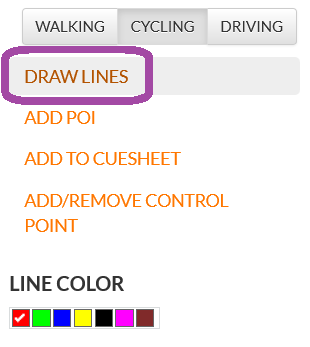
    Steveo, just swap to Draw Line, instead of navigating using the routing engine. I have to use this when routing from Burnshot Junction on the M90 to the Pub at Cramond Brig. It does not like going in one direction there for some reason.

    Dave C

    Posted 7 years ago #
  14. DaveC
    Member

    Posted 7 years ago #
  15. steveo
    Member

    So I've fixed the routing issue, it now routes correctly with a few mapping software.

    However the path has gone blue, any ideas? I'd really not want to give the impression its anything more than a cutting in the heather.

    Posted 7 years ago #
  16. rbrtwtmn
    Member

    The mapping of the detail of paths is something I don't think that OSM has quite got right yet - so some of your issues are to do with this.

    That said, I'd encourage you to think about the data first, not the colour that a line appears on any given map. There's a saying in OSM circles which is "don't tag for the renderer". What this means is don't change what you record in the details for a mapped feature because you want something to show up in one particular way on one particular rendering (style of map).

    However... on this occasion you're spotting one of the slightly unresolved issues... how to tag to explain that you are allowed to cycle... when you might not actually want to cycle there on an ordinary bike.

    You'll be getting blue on the OSM Outdoors rendering because the data says 'bicycle=yes'.

    As edd1e_h suggests, it might be better to change this. If you look at nearby paths, even good ones, they record 'mtb=yes'. This has become one way to indicate that you can cycle - but that you might want only to use a mountain bike.

    This convention might evolve still further, but it's probably a decent one to use if you want to indicate anything at all about cycling (given that the access legislation implies that you can take an MTB anywhere pretty much).

    A good work around at the moment

    Posted 7 years ago #
  17. steveo
    Member

    Cheers rbrtwtmn. I see what you're saying now, I've changed the tag to the mtb and hopefully that'll fix that.

    It's much safer to learn this stuff on a short path in the parts of the Pentlands that folk rarely walk let alone try to take their good racing cycles.

    Posted 7 years ago #
  18. rbrtwtmn
    Member

    steveo - it should be said (making some assumptions here) that you've started with mapping something relatively complex (details of access)... I did the same when I started, trying to map a gap in a cliff which has a name (how do add a name to something that is a lack of something else).

    If you want to get really comfortable with OSM (I'd encourage this) try mapping easy things to begin with. Just for the first 6 or 7 edits. Take a look at the real close detail of the streets you know. Add the website addresses to shops, bench locations, speed limits, simple paths in parks, even the number of steps in a flight. It won't take much of this before you feel entirely at home and can recognise some of the more complex issues - like the ones we've been discussing.

    And the number of people on here who are skilled at this is steadily growing so plenty of support available.

    Posted 7 years ago #
  19. steveo
    Member

    to be fair I only wanted to join a 50m section of path together!!

    Posted 7 years ago #
  20. chdot
    Admin


RSS feed for this topic

Reply

You must log in to post.


Video embedded using Easy Video Embed plugin