Hi,
Anyone cycled up Glen Ogle cycle path, and then down the cycle path no the other side, to Killin? What is it like? If I were to go on 23mm tyres would I come a cropper?
CityCyclingEdinburgh was launched on the 27th of October 2009 as "an experiment".
IT’S TRUE!
CCE is 17years old!
Well done to ALL posters
It soon became useful and entertaining. There are regular posters, people who add useful info occasionally and plenty more who drop by to watch. That's fine. If you want to add news/comments it's easy to register and become a member.
RULES No personal insults. No swearing.

 not a support question
Hi,
Anyone cycled up Glen Ogle cycle path, and then down the cycle path no the other side, to Killin? What is it like? If I were to go on 23mm tyres would I come a cropper?
In case no one here's actually done it - YaTube Go Pro footage is a fantastic way of checking out unknown paths and tracks....
| [+] Embed the video | Video Download | Get the Flash Video |
Yes.
The Glen Ogle railway path is good, there is a very steep climb up from the village to the trackbed level on a switchback path, quite a challenge fully loaded in the heat of summer but I'm sure it will be a breeze for a seasoned audaxer on skinny tyres, Dave :)
The old railway trackbed ends at Glenoglehead where you have to change sides of the road (no signalled crossing, but at least there are warning signs on the A85 to warn vehicles of the crossing. You then pick up the Forestry Commission road which is reasonable quality and no worse than any other FC surface. I managed it fully loaded on 32c tyres and was able to overtake some MTBs uphill in the process so it can't be that bad. Over the other side you then pick up the trackbed again towards Killin, which was compressed dust / ash / mud, pretty much like the Water of Leith path from the canal to Balerno. It might be quite mushy after a damp spell.
There's bits on the way down into Killin which are fairly hard but bumpy land rover track, however most of the surface is pretty good and a lot is actually paved. If you're thinking of getting on nearer Callander, there's quite bumpy sections that might be nasty on a proper road bike, particularly (if I remember right) around Loch Lubnaig.
particularly (if I remember right) around Loch Lubnaig.
Yeah, there's a dreadful, steep, narrow uphill section there which is like 4" deep of horticultural gravel! Only solution is to get off and push.
Or get a cyclocross bike *smug face*
Cheers, I'm recceing (sp?) a route of a 400. Just wondering what the surface is like. My plan is to route riders off the road at the climb out of Lochearnhead away from traffic, but then back on to the road down to Lix Toll where their speed will put them at less risk of traffic as the road is straight, until near Lix Toll, where the recently cleared trees make visibility better, before routing the riders off to Killin.
Taa.
Possible best to switch to the road at strathyre if going to callander as gets rubbish for a few miles past strathyre
I suppose it depends on how strong your road tyres are my continental contact sport are great on the road but in the last month had 2 flats from thorns, one on the path from Alloa to Dunfermline another on the cycle route over the closed bridge going in to fife
Mrs LB and I just did this two weeks ago. We used road into Killin after Glen Ogle section. Many gates with cattle grids which are narrow (prob on the video). Other bits like a pump track and only suitable for wider tyres. Would not ride with 23mm tyres. Not saying it couldn't be done but more a cross bike type of experience. We had 50mm Big Apples on tandem. After Balquidder the path zig zags upwards at a crazy steepness. Other bits have rapid steepness with loose surface. Very mixed. 30% is maybe on old rail line but other parts patched in. One of the best and newest bits is tarred beside road from Strathyre towards Loch Earn. However it then leads on to something that would be testing for many riders.
Just seen the video, they've cleared the forest plantation around the zigzags from Lochearn up to the railway trackbed since I was there. At least you'll get a bit more of a cooling breeze on the uphill now. It was oppressively hemmed in by spruce before.
Surface of the Glenogle viaducts section is good;
 Callander and Oban by andy a, on Flickr
Cheers, its clear I need to cycle up from Lochearn to Killin on this path. I'll get my CX bike up and running and get over then as soon as I can.
I may opt for sending riders up the main road then, as its ~90km from my Depart to Killin which if riders start at 6am would put them riding over after 9:30am... hopefully when traffic would be low, on a weekend. My original idea was to get them off the road as they climb as there are some blind corners up from Lochearnhead.
EDIT: Saying this, the access from just south of Lochearnhead looks good, as I can see tarmac, and if it continues on to the top of Glen Ogle, that would make a fine climb!
The zig zags are a fine climb for the strongest 1% of riders.
Don't be fooled by this pic!
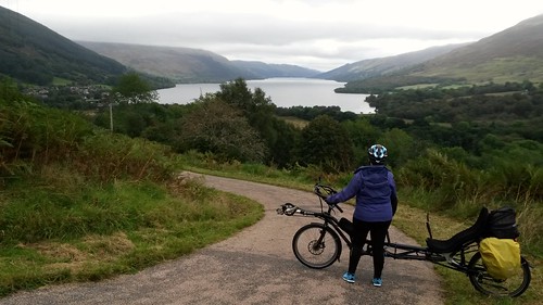 Dunblane to Killin via Glen Ogle by LaidBackBikes, on Flickr
Nice new tarmacced bit from Strathyre to Balquidder junction.
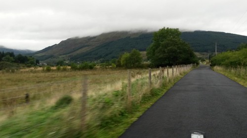 Dunblane to Killin via Glen Ogle by LaidBackBikes, on Flickr
You have some nice bits further south too.
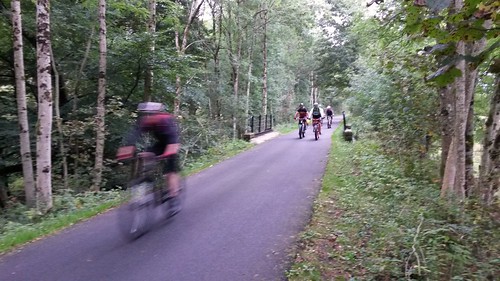 Dunblane to Killin via Glen Ogle by LaidBackBikes, on Flickr
But then you find out why people are riding fat bikes! You get glimpse of puddled potholed surface which was pretty demanding.
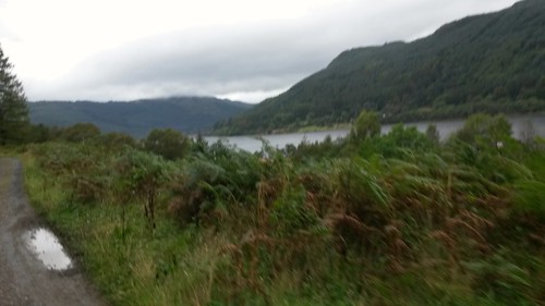 Dunblane to Killin via Glen Ogle by LaidBackBikes, on Flickr
Hi Dave (Laidback),
Many thanks for posting the pictures. My plan would be:
Route riders along the south side of Lochearn from Comrie. Left at the church onto the A84 at Lochearnhead. Then right (about turn) at Balquidder to join Route 7 north, to the top of Glen Ogle. Would this route be all tarmac? They would then rejoin the road for the descent into Lix Toll before turing right again towards Killin.
Lokking at Route 7 from Balquidder, I wonder why they didn't send the path up the railway line and save the switch backs later on? Sounds like a stubborn land owner to me!
Think you may join some rough stuff before making the tarred incline that leads to the zig zag section. You are right - must be landowner.
Final approach to Killin from Glen Ogle head is best on road as you say.
EDIT. Checking OS now to refresh memory of the ride. Think it will be fine. You join at NCN7 with new bridge over river and this then ducks under bridge where climb ramps up and up.
This is actually trackbed of old Comrie railway which at that point is at least 50m below other trackbed.
As I understand it, the zig zags are to connect two different railway lines which are close together but at different heights.
(Not that I have ever been on them; BoF has run some of the paths you are interested in during an ultra but I don't know which ones.)
According to http://www.railmaponline.com/UKIEMap.php and OS maps the two lines seemed to join at Balquidder. Why does the cycle path need to switch from one onto the other earlier on? That might be a landowner thing, or just a 'trackbed totally obliterated' thing (which could actually, in turn, also be a landowner thing.)
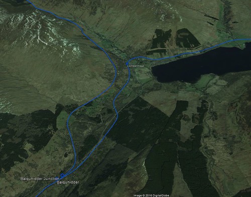 Balquidder and Lochearnhead by andy a, on Flickr
The trick here is getting up to the Glen Ogle level from the Lochearnhead level. The Callander & Oban Railway to Killin Junction and Crainlarich is the left-hand fork at Balquidder, the branch to the right was eponymous the Lochearnhead, St. Fillans & Comrie Railway.
The zig-zags are before Lochearnhead where the two lines get closer together for a bit, the gentler (but hard in railway terms) gradient up from Balquidder Junction has been lost now.
In answer to the question above, the reason it initially follows the lower level railway is that some substantial earthworks and a viaduct have been obliterated. The rest of the high-level trackbed though is in good condition and largely used as a forestry road.
What a shame. Perhaps a candidate for restoration when Scotland becomes genuinely cycle-friendly. I wonder how many centimetres of new M8 we could get for the same price.
Part of the Sustrans website has descriptions of the NCN routes - and at the bottom of each description is a space encouraging comments and contributions from users. NCN 7 (and associated routes) include helpful contributions from 'DougT' who has provided video footage - much of it focused on illustrating surface quality. Scroll to the comments at the bottom of this page:
http://www.sustrans.org.uk/ncn/map/route/lochs-and-glens-north
One of the links provides a list of videos.
Has anyone been up this route of late. I'm thinking of going Killin to Lochearnhead on a roadbike with 23mm tyres - would that be okay on the path? The road is not good news (did that on my first 300 on a bank holiday).
@amir
Went up there about 5 years ago - from what I remember it was pretty smooth most of the way, so I think you'll be OK on the path.
Amir,
I have ridden down from the pass at the head of Glen Ogle to the cafe at the old Kingshouse Hotel near Balquidder. Its fine for 23s if you caw canny.
I have not ridden the route up frm Killin to the head of Glen Ogle. The path from the top down to Lochearn head is fine gravel/dust and has been ridden smooth everywhere.
Have a look at my FB pictures from April, they show us cycling down the path.
Dave C
Thanks DaveC and panyagua
Cyclingmollie and I did a lovely circuit in glorious weather on Saturday. Starting in Crieff, we took in the Sma' Glen, Glen Quaich, the south road of Loch Tay and back via the south road of Loch Earn.
From Killin, we decided to take the cycle path to Lochearnhead. The path is indeed lovely and smooth in Glen Ogle. However the experience on the north side of the pass was more mixed. At the start for a couple of miles progress on our road bikes was slow due to the use of largest stones. This was pretty sketchy going up Hull. Then the forestry track was largely hard packed soil, not so bad in the weather. Then bizarrely the last stretch was tarmac, before arriving at the Stoney car park at the top.
It would be good to think that they'd adopt the nice smooth surface on south side or the tarmac, but the signs aren't good. The stoney bit near the start looks new.
It's not as bad as the minor road from Langholm to Moffat via Boreland and it's possible that the section of uncompacted ballast stones is just the bottom layer of what will eventually be more tarmac.
Did the Zigzags today from South Loch Earn and then down the road to Killin.
Quite a climb, with fairly steep gradients in the corners - glad I wasn't a laden down tourer.
Once up on the railway, I really liked looking down on the road and all the traffic I wasn't being bothered by :-)
Brand new bridge went in at Kendrum Burn viaduct amazing mass concrete structure with steel centre span, which kept you at height from Balqhuidder Station, but a short divert required where railway and elegant cast iron footbridge incorporated in garden of big house. Or are you climbing up from Scout hut at Lochearnhead Station?
Interesting vandalism in track recovery work = Glenogle Viaduct too narrow so lets knock off parapet to make space. Railway used to head for junction at Lix Toll for Killin but cycle rout maintains height to use Forest track around hill from summit car park.
2 nice early 17th century bridges on Loch Lubnaig section Stank probably still OK but Laggan Farm owner bulldozed out a lot of old village remains and old road (in pre 1700 military surveys) so we might have lost that one (classic random stones used to form arch (not ashlar, and certainly no keystone). You can also trace Caulfield's Military Road (late 1700's) below railway in Glen Ogle.
Killin Railway also an early adopter of mass concrete with composite wrought iron/concrete railway bridge across Tay.
I think it's the Dochart or Lochay at that point.
Official name = Kendrum Viaduct map says Kendrum?
You must log in to post.

 Cycling in Edinburgh Flickr group
Video embedded using Easy Video Embed plugin
 posts
posts