Spotted on Facebook this morning.
CityCyclingEdinburgh was launched on the 27th of October 2009 as "an experiment".
IT’S TRUE!
CCE is 17years old!
Well done to ALL posters
It soon became useful and entertaining. There are regular posters, people who add useful info occasionally and plenty more who drop by to watch. That's fine. If you want to add news/comments it's easy to register and become a member.
RULES No personal insults. No swearing.

Nice, thanks for posting. I'd love to live in a disused railway station, and this reminds me of one I spotted on Saturday:
https://goo.gl/maps/mGmY8YPenxL2
To have your own waiting room, platform and fau railway! I'd have some track bed pu back in and a couple of sleeper carrages.
What is labelled "Balerno" is in fact the Currie goods yard. The old station building is here; https://goo.gl/maps/NdB7oDZ9WYT2.
Duddingston & Craigmillar has the camera pointing the wrong way, if you look over the other side of the bridge some of the platforms are still there.
Apart from that, bravo!
There's a lovely old station building in use as a house on the platform at Trinity, just beyond the tunnel before you run down the hill to road level.
There's a lovely old station building in use as a house on the platform at Trinity, just beyond the tunnel before you run down the hill to road level.
Yes I've seen this, looks like a small single storey dwelling from the bridge/road level. But is a multi story below. I also like the house near the Old Chain Pier.
A friend of mine used to live in the former stationmaster's house at Loanhead. It doesn't look it but it was a remarkably large house.
Doesn't quite belong on this thread but close enough; just came across this:
http://www.geograph.org.uk/photo/3808544
"
Workmans Bothy
The body of a Park Royal railbus built in 1958, SC79971, finds employment as a workmans shed in Millerhill yard.
"
Princes Street railway station? Surely they mean "the Caley".
The photograph shows the Caledonian Hotel, but the railway station was Princes Street.
@kaputnik
That is the old station master's house of Balerno. The station was north and west a few hundred yards I believe though as ever happy to be corrected. The line was marginally east of the house then curved north and west as I said. They are building more houses and one objection was linked to possible subsidence caused by railway cutting, so what many took as a little wall has been revealed as the top of the bridge taking the road over the cutting.
Interesting. It was always known as the Caley station, despite the formal title.
The YouTube is interesting but as kaputnik says the Balerno photo is Currie. The yard shown was bought by someone who was going to make it into an international design centre but I see that has translated to houses.
I spoke to my 87 yr old neighbour a few weeks back. He told me that Dalgety Bay had a platform during the war about 500m eat of where the present station is. He recons you can still see the old platform. I need to investigate.
He's right you know, except back then it was called Donibristle and was a workers platform for the Fleet Air Arm airbase RNAS Donibristle (where much of the modern industrial estate is now built). My great uncle worked there late war/early postwar as an engine mechanic. There's some photos of some of the remains here; https://www.railscot.co.uk/locationnew.php?loc=Donibristle%20Halt
One of the old coal lines down to St. David's Harbour was apparently used for bringing seaplanes to/from the base.
is that an old station about 200m before the end of Trinity path ? looks like one. I guess the path is on the old Granton line ?
@Iain McR yes that's Trinity station that I referred to above. Next stop after that was Granton Harbour.
Diagram below shows relative arrangement of other stations.
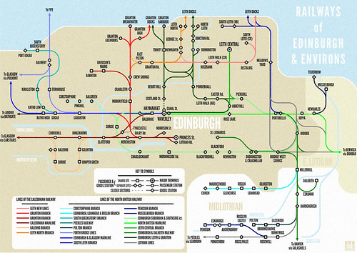 Edinburgh Railways by andy a, on Flickr
*Thread drift alert* So that's where Donibristle from the poem is! Thank you :)
http://skinnyfairtradelatte.blogspirit.com/archive/2010/07/19/the-train-to-glasgow.html
Thanks LivD, this is a lovely poem, and has given me a great idea for a bit of theatre, at my sons' school, Donibristle in Dalgety Bay. We could get them dressed up, and act out the bits of the poem as it is read out, for the school in their christmas play!
Cheers! Dave C
*Thread drift alert* So that's where Donibristle from the poem is! Thank you :)
http://skinnyfairtradelatte.blogspirit.com/archive/2010/07/19/the-train-to-glasgow.html
Wow - haven't seen/heard that in so long that I'm not 100% sure this isn't the first time. Probably a Singing Kettle version I knew.
I believe the original route of the Niddrie to Leith section of the E&DR was further west, you can still see the embankment it used on the west side of Duddingston Park/Baileyfeild Road. The first, short lived, Portobello station was on this section but I've no idea where. Wikipedia has it further east on Stanley Street which doesn't quite make sense to me.
It was later rerouted join the NBR main line east of Porty at which point a new station on the mainline was built.
@urchaidh yes indeed you are right, this was originally laid before the North British took it over and rebuilt it. The E&DR was horse-hauled throughout (apart from the winding engine for the St. Leonards tunnel) and of a different gauge, with rails and wooden bridges not up to the task of locomotive haulage.
The line in question ran from Niddrie West parallel to Duddingston Park, I'm not sure exactly when the section closed, but probably 1860sish. Railscot says 1849, but it's in a number of OS maps as late as 1857. I think the main reason it was probably changed was to reposition the junction to face towards Edinburgh rather than running direct through from Dalkeith.
The 1854 OS map shows a 2 platform station immediately next to Southfield Place. The later maps all show the larger island platform station about 100m further east. There is also a single platform marked on the westbound line immediately to the west of Southfield Place on the 1893 town plan, it's not there by the 1940s version.
The section was extremely busy with coal traffic and the NBR later duplicated all the access to the docks by building an entirely new coal-only railway parallel to the existing one called the Lothian Lines to provide priority access to the docks. This makes mapping out the railways and junctions in the area a rather difficult prospect.
"This makes mapping out the railways and junctions in the area a rather difficult prospect."
This is attempting to do the whole of the UK.
http://www.railmaponline.com/UKIEMap.php
I'm aware of some inaccuracies in Fife, but I have looked at Edinburgh in detail.
There's a little bit of an overly convenient historical storyline in that article. The Union Canal was late to the party in canal terms, it was only opened in 1822 and work started on the Edinburgh & Dalkeith Railway in 1826, it had been planned well before that. You didn't quickly or easily build, plan and get the necessary finance and parliamentary ascent for such undertakings.
Also, most of Edinburgh's coal came from Midlothian by cart (the carters had a monopoly as did the Turnpike Road Trusts or other private road proprietors). Fife coal mainly went to the continent and this suited the Midlothian Coalmasters as it reduced competition and pushed up the price of their already expensive product.
The E&D was not built in direct response to the Union Canal, it was basically built for the same reasons, to try and control the coal market. The E&D was promoted by the same landowning families of Midlothian who happened to "own" the coal and had the monopoly on it. The Union Canal was promoted by those trying to bring in coal from the West which would have been cheaper than Midlothian cart coal and a serious threat. Midlothian had to reduce the costs of transport to maintain their advantageous supply position. The Glasgow & Garnkirk railway had permission as early as 1824 to extend to Edinburgh and Leith, and the Edinburgh & Glasgow Railway eventually completed the link in 1842 (effectively killing the Union Canal and helping relegate the E&D railway to a dead-end coal siding. There were other contemporary plans for canals and railways that came to nothing. The railways and improving technology opened up more coalfields around Edinburgh, with concentrations at Niddrie, Prestonpans and Tranent and the coal monopoly was effectively ended.
Of course as this forum has taught us, Edinburgh's first railway was the Edmonstone Waggonway.
"Of course as this forum has taught us, Edinburgh's first railway was the Edmonstone Waggonway."
But not the first Lothian one(?)
The Innocent Railway one is quite good, even getting praise from commenters.
What I would do to have a go on the good old trains sometimes.
But not the first Lothian one(?)
From Wikipedia:
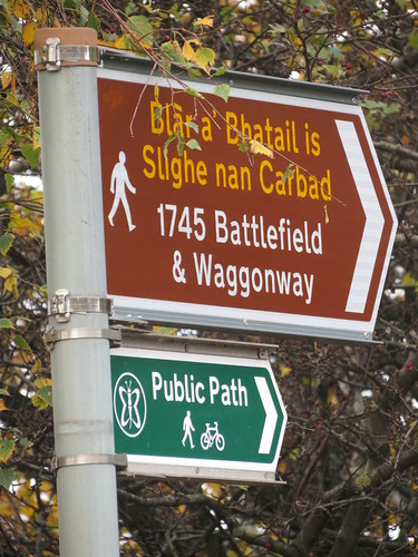
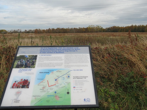
The Tranent to Cockenzie Waggonway was an early waggonway, possibly the first in Scotland, opened in 1722. It was 2 1⁄2 miles long and connected coal pits at Tranent with a harbour and salt pans at Cockenzie in East Lothian, Scotland. The track was wooden, and wagons were drawn by horses. The Battle of Prestonpans in 1745 was fought across the line.
Aye.
Well worth an explore -
And go up the pyramid -
There's an app too!
You must log in to post.

 Cycling in Edinburgh Flickr group
Video embedded using Easy Video Embed plugin
 posts
posts