CityCyclingEdinburgh Forum » Infrastructure

M2GS - Meadows to George Street

(179 posts)

  1. HankChief
    Member

    A thread for the Community Links Plus Finalist 2017.

    But will it win funding?

    (I'm sure we've talked about this before but can't find a thread)

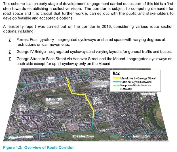
    "Meadows to George Street-Places for People - City of Edinburgh Council. This project proposes to create a direct cycle link between The Meadows and George Street, as well as the Old and New towns of the city centre along Hanover Street, The Mound, Bank Street, North Bank Street, George IV Bridge and Forrest Road. If successful, the ‘Meadows to George Street’ project aims to provide a major redesign for walking and cycling in the city, creating safe, coherent and attractive routes through the city centre. With over one third of people in Edinburgh cycling at least once a month and a total of 16.5 million bike journeys made annually, the implementation of strategic cycle infrastructure in a city centre location would potentially increase this level and encourage cycling as the favoured commute option city wide."

    Posted 6 years ago #
  2. Frenchy
    Member

    So this is getting funded!

    There are a few bits of the route which will need some careful attention:

    The MMW-Forest Road junction. Currently, drivers turning right from Teviot Place just merge into the left hand lane, apparently unaware that cyclists are coming from MMW.

    The Bank Street-The Mound section is quite narrow. Is there will to close it to motor vehicles, or at least make it one-way?

    Crossing Princes Street tram tracks.

    Taxi rank at the south end of Hanover Street. This took me by surprise the first few times I went this way. Taxis queuing on the double yellow lines doesn't help, of course.

    George IV statue roundabout. I don't think this is too bad, with the traffic lights, but it could certainly be better.

    Posted 6 years ago #
  3. I were right about that saddle
    Member

    I have twice had a well-founded belief that I just escaped death whilst cycling. The second was on North Bank Street, going uphill in the pink lane when I was just taking the turn to cross the junction with St Giles Street and a car passed into that street from North Bank Street at speed, close enough to touch. Simply hadn't seen me and treated the junction as a straight ahead.

    The Forest Road thing could be sorted for buttons.

    Posted 6 years ago #
  4. I were right about that saddle
    Member

    Is the Mound actually too steep to be a cycle lane without building a switch-back(s) on the NGS estate?

    Posted 6 years ago #
  5. NiallA
    Member

    Are there any accessible plans for what the project would entail?

    Posted 6 years ago #
  6. wingpig
    Member

    "Is the Mound actually too steep to be a cycle lane without building a switch-back(s) on the NGS estate?"

    Though unpleasant for cyclists, it's slightly easier for cyclists to get round that uphill corner than pedestrians, who have a tighter turn and steeper slope and usually bumbling clouds of people heading in both directions who have no idea where they're going, whereas most cyclists in the worthless strip of red paint are heading in the same direction. Instead of a switchback/slope there could even be an elevated path attached to the side of the building emerging onto St Giles St opposite the back door to the courts.

    Could there be a one-way-at-a-time-for-motor-vehicles stretch between the end-of-Market-Street junction and St Giles Street, so that pedestrians on the hemmed-in footway outside Coda could have a little more space, as well as offering a segregated cycleway on both sides? Considering the footfall and the lack of footway-space the light sequences are quite bad for pedestrians, if not as lengthy as Frederick Street.

    Posted 6 years ago #
  7. Stickman
    Member

  8. I were right about that saddle
    Member

    @Stickman

    Stop that at once, please.

    Posted 6 years ago #
  9. wingpig
    Member

    The canvas: not blank; covered in scribbles of cars.

    [+] Embed the video | Video DownloadGet the Video Plugins

    Posted 6 years ago #
  10. Stickman
    Member

    "uphill only"

    This (from Spokes Twitter) suggests so:

    https://farm5.staticflickr.com/4414/36911902090_5bf4ca33a0_z_d.jpg

    Posted 6 years ago #
  11. neddie
    Member

    George IV Bridge is crying out for more space for cafe seating.

    Ideally, it would be fully pedestrianised with cycle lanes. Could the bus services (23, 27, 41, 42, 67) be rerouted?

    Even if not, I'd make it buses-only and reduce the carriageway to something with no centreline and only just wide enough for 2 buses to pass (in opposite directions)...

    Posted 6 years ago #
  12. wingpig
    Member

    Has the central cobbled bit ever been cited/bagsied as a vital component of the original streetscape, integral to the visual appeal and historic character of the area? It's currently either a de facto pedestrian refuge or U-turn zone, depending on whether one is a pedestrian or taxi driver. Bike lanes in the middle would hopefully keep them free from beign parked on for vital deliveries of vital pastries, residents and intoxicants for busy cafés/hotels/pubs/libraries, but make it more difficult to park at them to consume services.

    Posted 6 years ago #
  13. ih
    Member

    The central cobbled bit is relatively new. Certainly 21st century, but I don't know exactly when.

    Posted 6 years ago #
  14. Stickman
    Member

    http://www.edinburgh.gov.uk/download/downloads/id/10052/meadows_to_george_street.pdf

    This doesn't fill me with great hope:

    The north-south corridor in question is subject to competing demands for road space and considerable further work is required with the public and stakeholders to successfully develop the project.

    Posted 6 years ago #
  15. Morningsider
    Member

    I think there should be a presumption in favour of segregated cycle lanes and wider footways in any community links scheme. Drivers, businesses etc. should have to provide evidence of serious detriment as to why these should not be built. No evidence - scheme is built unchanged.

    Why should we have to rehearse the same arguments again and again in favour of cycling and walking, when this is meant to be national and local policy.

    Posted 6 years ago #
  16. Rosie
    Member

    @Morningsider - yes, should be assumed along with pavements, yellow lines and all the other bog-standard features of road building and improving.

    Posted 6 years ago #
  17. russellelly
    Member

    Interested in this as it's a route I use frequently. George IV Bridge is absolutely crying out for a redesign, I hope the proposals are 'brave' in the sense of serious space reallocation away from private motor vehicles and parking. The horrid painted cycle lane between car lanes just south of the National Museum is completely unfit for purpose and in need of a serious rethink.

    Also noteworthy that this would like to the so-called Quality Bike Corridor connecting the Meadows to Kings Buildings. An opportunity to revisit that missed opportunity I hope.

    Posted 6 years ago #
  18. gkgk
    Member

    @russell, Weird thing with the Bristo Pl section you mention, just S of NMS, is that they allow dual kerbside parking 9.30-4.40 M-F. That's a lot of space, two lanes worth, used by, what, 4 or 5 car/van owners, rather than 500 MMW cyclists? The Hotel du Vin has a courtyard, and there's parking around the corner.

    Posted 6 years ago #
  19. chdot
    Admin

    They also said the Meadows-GeoSt project may not have the bulk of its implementation starting till 2020 because, first it will need Orders (once a final option is decided) and second it will form part of the City Centre Transformation and design options must tie in with that.

    http://www.spokes.org.uk/wp-content/uploads/2017/11/171129-ATF-DdF-report.pdf

    Posted 6 years ago #
  20. acsimpson
    Member

    Best postpone Picardy Place too then.

    Edit: I've just seen the second thread you posted this on.

    Posted 6 years ago #
  21. neddie
    Member

  22. chdot
    Admin

    Next steps
    We will use people’s feedback about their experiences of current street conditions to start developing concept ideas for making improvements.

    In Autumn 2018, we will share these concepts through further consultation.

    So, more free advice from CCEers (and others) followed by noisy complaints by traders - ‘all our customers come by car’ and drivers ‘traffic flow reduces air pollution’.

    Posted 5 years ago #
  23. Stickman
    Member

    "We need balance"

    Posted 5 years ago #
  24. chdot
    Admin

    Have your say
    To share your views, you can use the online Placecheck tool (external link). Tell us what you like, don’t like and want to see improved on these streets

    Placecheck tool??

    Posted 5 years ago #
  25. Frenchy
    Member

    Placecheck tool??

    This was used for the recent Musselburgh consultation thing too.

    Seems to work fairly well.

    Posted 5 years ago #
  26. neddie
    Member

    Thank you for signing up to receive Meadows to George Street – Streets for People project updates at http://www.edinburgh.gov.uk/meadowsgeorgestreet.

    By way of a short update, our project team has been on the route talking to users in June, and will be again on Saturday 21st July, from 10am-3pm, near Greyfriars Bobby. Please do come along and chat to us if you would like to share your views or get more information about the project.

    The online Placecheck tool has proven very popular and we’re very grateful to everyone who has taken the time to share their views. It is still open for comments on what you like, don’t like and would like to see improved on the route, and we’d encourage you to use that and to share widely with your networks. It will remain open until Tuesday 31st July.

    Continuing the engagement process, workshops will be held with businesses, community representatives and stakeholder organisations in September to gather their views and we will be directly contacting these in due course.

    Our next project update will advise on the proposed stages of developing concepts for the route to improve walking, cycling, public space and access for all.

    (edited slightly)

    Posted 5 years ago #
  27. neddie
    Member

  28. piosad
    Member

    Slightly surprised Spokes makes no recommendations at all for George IV Bridge between Chambers Street and Victoria Street. Surely getting rid of all the superfluous road space and parking (and ideally of private cars) should be on the table?

    Posted 5 years ago #
  29. neddie
    Member

    I think Spokes have kept their response as high-level as possible, to avoid constraining the designers with too much detail and to avoid a lengthy unreadable document at this early stage.

    They mention general traffic elimination (or reduction) on this corridor, so I think that should be enough to achieve the aims of removing parking & superfluous road space.

    Posted 5 years ago #
  30. chdot
    Admin

    Meadows to George Street Streets for People project: Invite to Stakeholder Workshop - Monday 10th September, 1300-1600

    CCE invited.

    Anyone interested/able to go please PM.

    Posted 5 years ago #

RSS feed for this topic

Reply »

You must log in to post.


Video embedded using Easy Video Embed plugin