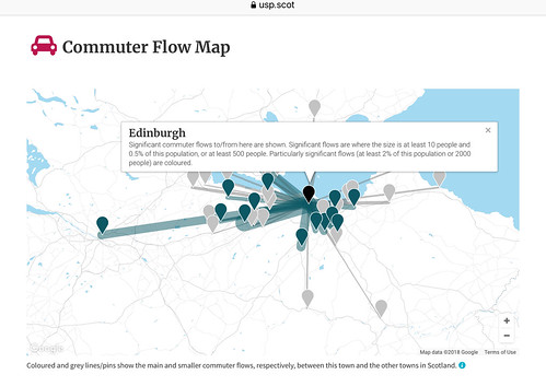
There’s been interest in this before, but this version is interactive (click link) and see flow to and from Ed
CityCyclingEdinburgh was launched on the 27th of October 2009 as "an experiment".
IT’S TRUE!
CCE is 17years old!
Well done to ALL posters
It soon became useful and entertaining. There are regular posters, people who add useful info occasionally and plenty more who drop by to watch. That's fine. If you want to add news/comments it's easy to register and become a member.
RULES No personal insults. No swearing.

There’s been interest in this before, but this version is interactive (click link) and see flow to and from Ed
i see there's a hovercraft route back in action from the lang toon to leith
stagecoach aqua-east
@chdot, nice map
@bax hovercraft usually sells out in advance so not so easy to rock up on the day and stroll on. Would need a Brompton or other folder.
The map only shows start and end points, not routes (but then you all knew that; I only mention it in case anyone is fooled in to thinking otherwise).
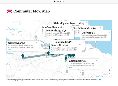
I'm quite surprised that the North Berwick numbers are so low: roughly a sixth of the number commuting from Penicuik, for example, for which a rail connection appears to be so difficult to justify. And yet the East Lothian rail commuter market so often seems to be treated as all but sacrosanct. Couldn't be anything to do with North Berwick, Drem, Longniddry and their ilk having a demographic rather higher up the income/influence/likelihood-of-making-a-fuss scale, could it? (Actually that may be unfair, since the map doesn't seem to have flow numbers for the smaller East Lothian settlements. Perhaps if you add them in then it redresses the balance somewhat between the seaside golfing resort and the ex-industrial town on the North Esk.)
@ejstubbs It will have a lot to do with the fact that the North Berwick line exists, whereas you would have to spend a fair amount of cash to build a Penicuik line. I doubt there'd be much of a clamour for a North Berwick rail link if it didn't already exist.
Also, I wonder if the commuter numbers include school children. I've seen quite a few Heriots blazers getting off the North Berwick train.
Given the distances and populations, Peebles would be a better comparison for North Berwick than Penicuik.
Random selection of places -
In spite of car logo, I presume this is all means of transport(?)
I suspect a high proportion of Inverkeithing commuters use the train, but certainly not Dunfermline ones.
Some will park and ride.
I was reading something the other day about why the North Berwick line was never closed, and I can't for the life of me remember where the article was.
Penicuik should well deserve a railway connection again. The problem is having to go around the hills.
Back in t'day, Penicuik even had two rail connections, one to the Ladywood gasworks on the north side, just before the big Tesco on the A701; and one to the station to the south side. The gasworks' Glencorse Extension was part of the Loanhead and Roslin branch, so you had to go to Millerhill and thence onto the ECML to get to Waverley. Some of that route of course is now the splendid cycle path to Shawfair, but great chunks of the rest of it, Penicuik to Roslin, is built on. The passenger station took the low level Esk route via Auchendinny, joined the Peebles railway at Gorton Junction, then went via Hawthornden and Polton to the Esk Valley Junction where it was joined by the railway from Lasswade and Bonnyrigg. So at least from Esk Valley Jct you're back on the Borders Railway, which goes to Millerhill and thence onto the ECML to get to Waverley.
Whichever way you look at it, you really have to go round the houses, metaphorically and literally, to get into Edinburgh. Perhaps they could build a new station in Penicuik, tunnel to Gowkley Moss with a wee station for Bush and Roslin and Bilston, another station at Straiton for the P&R, then tunnel northwest and emerge at a new junction in the bounds of Slateford sidings to meet the WCML. If you're tunnelling, the distances are really quite modest.
North Berwick spur line is less than 4 miles, of course, from where it diverges from the east coast main line. Drem and all the other stations are on the main line. Amusingly there was briefly a Dirleton station, in the middle of a field, barely any closer to Dirleton itself than the NB station is.
Peebles is about 8,500 people. Haddington is about 11,500 people. Haddington would only require about 3.5 miles of track and the track bed is pretty much all still there. This seems like a bit of an overlooked opportunity.
Aberlady and Gullane spur line pretty much a non-starter though - track bed is now forest and fields.
@snowy, do abellio know? The extra platforms at Waverley may be an attempt to increase capacity to allow new routes?
“This seems like a bit of an overlooked opportunity.”
Recently
“
The successful applicants and the potential rail elements that the appraisals will consider as part of the studies are:
East Lothian Council – Haddington
“
https://www.transport.gov.scot/news/local-rail-development-fund-set-to-award-grants-of-681k/
@Arellcat: The passenger station took the low level Esk route via Auchendinny...
There was a passenger station at Glencorse as well: https://www.railscot.co.uk/img/38/942/ - I know that the train is a railtour, not a scheduled service, but the photo clearly shows the platform and station buildings. However, the line beyond Glencorse station served only Mauricewood colliery and, as you say, the gasworks: https://www.railscot.co.uk/img/62/21/ Apparently the Penicuik Railway, which operated the line to the station under the A701 bridge, took the Edinburgh, Loanhead and Roslin Railway to court to prevent it extending its passenger services closer to the town centre.
The Penicuik Railway which, ran the service to the station at the south end of town, left the Peebles Railway just south of Rosewell and Hawthornden. It was more than a passenger line: at Penicuik itself it served two paper mills: Bank Mill on the other side of the bridge over the North Esk, and Valleyfield Mill on the slopes to the north of the station: https://maps.nls.uk/view/82878441 You can still see the additional arch in the A701 overbridge which gave the railway access to Bank Mill. Scheduled passenger services on the Penicuik Railway ceased in 1951 but it remained open for freight until 1967.
Apart from the recent residential development at Auchendinny (which would be problematic) I believe that the solum of the Penicuik Railway/Peebles Railway is still largely intact as far as Eskbank. Although it's a fair while since I last rode out that way so things may have changed since then eg as a result of the construction of the Borders Railway.
...emerge at a new junction in the bounds of Slateford sidings to meet the WCML.
There are existing capacity issues with the current junctions west of Haymarket. I understand that these should be eased when EGIP is finally completed but even then I'm not sure that a whole new railway could readily be accommodated (especially if the agitation to restore passenger services of some kind on the Edinburgh South Sub ever comes to anything). I believe that capacity on the eastern approaches to Waverley is due to be significantly enhanced - possibly to do with the proposals to reinstate passenger services from places on the ECML such as East Linton - but also AIUI to enhance capacity (at least at Waverley) for the Borders Railway. That would suggest that having a Penicuik service join the Borders Railway to access Edinburgh might be more in tune with existing planning than a whole new railway coming in from the west.
@chdot: In spite of car logo, I presume this is all means of transport(?)
I hadn't noticed the car logo. I suspect that may explain the puzzlingly small numbers for North Berwick: a lot of the commuting from there is by train. Which rather renders moot the rest of the burbling on this thread about old and possible future train services...
I saw a clickable version of that map recently, but it was on twitter and there's no way I'm going to be about to find it again. It was much more interesteing.
No, the thing I saw was much better.
You could click on quite small areas, filter on modes of transport and direction of travel.
I'll see if I can find it.
fimm - could be this:
That last one is nice - you can see modes of transport. It's based on the 2011 census so no Borders railway. Also it differentiates between driver and passenger in cars. I don't know how detailed the questions were underlying this (eg some people might use the bus some days and car others, and travel to different places).
No cyclists from Eskbank - that's especially surprising (and incorrect)
Could it be down to the statistical disclosure control
The USP map and the datashine map are both based on the 2011 Census Data, and despite the use of the car logo.... it does seem that thye USP map does includes all forms of transport.
The USP Methodology pages says:
"The second map on each town page shows significant commuter flows between the town being viewed and other towns. Particularly significant flows (at least 2% of the total population of the town being viewed, or at least 2000 people) are coloured, while smaller ones are shown in grey. The size of each flow is proportional to the thickness of the lines. Inflows and outflows are not distinguished, and are added together to calculate the total flow size. Counts of the inflows and outflows, for each flow line, can be seen by clicking on the corresponding flow line.The commuter flows are calculated from the origin destination workplace tables published by the National Records of Scotland in December 2015 and based on responses to the 2011 census, aggregated and filtered from statistical “data zones" into the town geographies. Only the flows between pairs of towns in Scotland are shown, this excludes flows within a town, to/from rural areas, to offshore workplaces (e.g. oil rigs), cross-border commutes (e.g. to England), home workers and those with no fixed place of work. The town to town flows shown on the maps represent, in total, approximately 36% of the working population (those aged 16+ and in employment the week before the census) of Scotland."
Morningsider - that's it!!!!!
You must log in to post.

 Cycling in Edinburgh Flickr group
Video embedded using Easy Video Embed plugin
 posts
posts