
The changes at Midmar Avenue are already in - fast work... 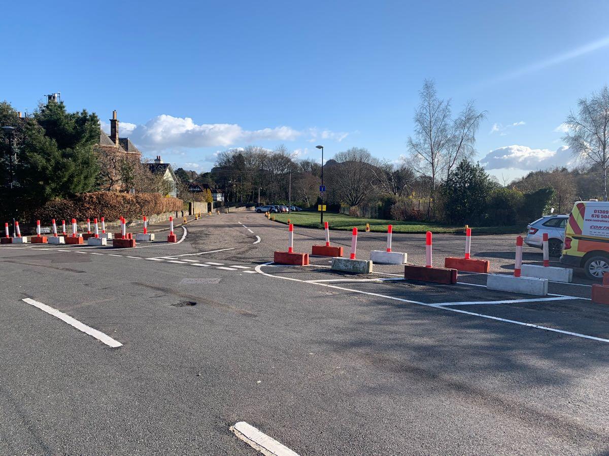
CityCyclingEdinburgh Forum » Infrastructure
Greenbank to Meadows Quiet Route (Inc Braid Road/Estate)
(779 posts)-
Posted 5 years ago #
-
@CycleAlex: One way plug at Greenbank Terr/Braid Cres
Interesting one, that. Arguably, drivists manoeuvring clumsily around that junction is one of the most tedious causes of delays to traffic on Greenbank Terrace, and may indeed be behind Lothian Buses' complaints (which proved to be largely unfounded anyway).
Interesting that revision b includes blocking the slip at the mini roundabout at the Braid Road/Hermitage Drive junction. I did think that it would be too tempting for some drivists to nick through there and then do a clumsy U-turn on Hermitage Drive to get back on to Braid Road southbound. Also that the changed priorities at the Braid Road/Braid Crescent junction would not be much of a deterrent to determined rat-runners. It's actually quite encouraging to read that ..it is acknowledged that further measures may be required to discourage through traffic on Braid Road between Morningside Clock and Hermitage Drive.
It's not clear that the changes are going to do much if anything to deter traffic using the Midmar Drive/Hermitage Drive route - but maybe that's deliberately not the intention. Would be nice, though, if "something could be done" to dissuade drivists on those roads from exceeding the 20mph limit (as is demonstrated by survey data here). I don't foresee that the changes currently planned/being implemented will have much effect in that regard.
Posted 5 years ago # -
“
Now, as part of a redesigned layout, the council says it will reopen one-way for southbound traffic on Monday and segregated cycleways will be installed following approval by the transport and environment committee in January.There will also be traffic calming measures around Midmar Drive to protect the Meadows to Greenbank Quiet Route, including no entry onto Braid Crescent from Comiston Road and “diagonal filters” at the junction of Braid Road and Hermitage Drive, the junction of Hermitage Gardens and Cluny Drive and the junction of Braid Avenue and Cluny Drive, intended to remove through-traffic from the affected streets.
“
Posted 5 years ago # -
Noted the paintwork on Braid Road has been changed for the southbound opening. I hope that they do segregate the cycle lane to prevent people from parking in them and to make it much harder for people to drive the wrong way down the road.
Posted 5 years ago # -
Here's an updated map showing the Quiet Route with the new interventions/Braid Road reopening.
Posted 5 years ago # -
Went to check it out
Met a car coming downhill illegally past the Braid Hills Hotel
Quelle surprise
Posted 5 years ago # -
That diagram is really helpful, although I wonder if there is a missing 'traffic route' along Braidburn Terrace & Braid Road?
(Or maybe along Hermitage Gardens and back onto Hermitage Drive if we're being really cynical.)
Posted 5 years ago # -
Um
Map
That’s not where Blind School is(?)
Posted 5 years ago # -
@jonty - Not sure how tongue in cheek that is, but turning right out of Braidburn Terrace is not allowed for drivers. So anyone coming along Braidburn Terrace and wanting to go south on Braid Road would have to go via Hermitage Gardens, yeah.
Cyclists are exempt!
Posted 5 years ago # -
@chdot: yeah, and they have also misplaced the filter on Canaan Lane towards Morningside Road and missed the South Morningside Primary Annex on Canaan Lane off the map completely. The council don't do themselves any favours with the mistakes on maps - Paul Bailey harped on for ages about how them originally misspelling Hermitage Drive as "Heritage Drive" was proof of the lack of attention to detail.
Posted 5 years ago # -
I took this route into Braid Hills today. Loved it. Only criticism was going to be the section along Hermitage Drive being busier than I would've liked, but it turns out I went the wrong way.
Posted 5 years ago # -
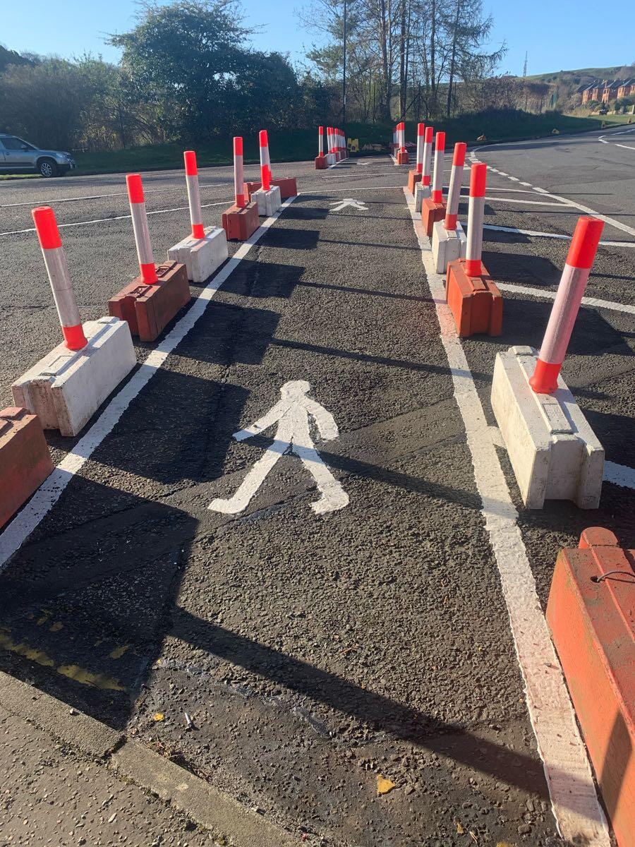
The filters/changed priorities are all in place, Braid Road itself is still closed however. Since Hermitage Dr now dead-ends (for the weekend, at least!) at Braid Road, it's probably the quietest it's going to be!
A rather bemusing give-way arrangement at one of the diagonal filters though. Made all the more odd by the other filter having no give-way lines!

 Posted 5 years ago #
 -
Just cones??
Posted 5 years ago # -
Cones that taxi drivers are already moving... https://twitter.com/EdinKennedy/status/1383134432865976327
It was meant to be water filled barriers.
Posted 5 years ago # -
Cones quickly replaced with metal barriers.
There was also free entertainment on Hermitage Drive for all. Just how many road ahead closed/no motor vehicles/etc signs will drivers go past before becoming shocked that the road is closed.
Posted 5 years ago # -
“Just how many”
Infinite?
Posted 5 years ago # -
@CycleAlex: The barrier on Hermitage Drive confused me, too, and I was on my bike.
There is no closure shown on Hermitage Drive on the map posted on here the other day by Pringlis, nor on the plans posted by Cllr Arthur on his blog a week or so back. With Hermitage Drive closed westbound after the junction with Hermitage Gardens motor vehicles can't access Braid Road southbound from that direction. Braid Road itself is closed southbound at the Hermitage Drive junction, with big "no entry" signs (per the photos posted above), and motor vehicles travelling east along Greenbank Drive can't turn right to access Braid Road southbound either.
As far as I could see, although Braid Road is "open" to motor vehicles southbound beyond the Hermitage Drive junction, there's actually no way for a motor vehicle to access that stretch of road.
Has someone made a boo-boo?
Posted 5 years ago # -
Thinking about this again, I realised that the unused barriers that used to be at the south end of the closure were all stacked against the wall backing on to the petrol station. If the unused ones that used to be at the north end were also left lying around, could some scallywag or local activist wanting to make a point have "repurposed" those barriers to create an unofficial closure on Hermitage Drive? Somehow that seems marginally more likely than the SfP planners having made such a significant mistake...
Posted 5 years ago # -
ejstubbs Braid Road isn't meant to be open yet, hence the closure on Hermitage Gardens to stop people driving on it (as the mini-roundabout is gone). Opens on Monday, presumably once the cycle lanes are segregated.
Posted 5 years ago # -
Oh well, bang goes my little Saturday night wine-fuelled conspiracy theory then!
There were no defenders on the cycle lanes today, hopefully as you say those will get done by Monday.
I also couldn't help noticing yet again the dark grey panel van that always seems to be parked outside the cafe. Today it was facing northbound, occupying the cycle lane and on the DYLs. Since no action ever seems to have been taken about it when the road was supposed to be completely closed to motor vehicles, I will be interested to see whether that blind eye continues to be turned following the official southbound reopening.
Posted 5 years ago # -
Someone has updated OSM - is that the correct layout with the diagonal filters?
https://www.openstreetmap.org/#map=17/55.92136/-3.20717&layers=Y
Posted 5 years ago # -
Yes, plans are here under the “ Braid Road & Braidburn Terrace” section: http://www.spokes.org.uk/documents/members-campaigning/edinburgh/edinburgh-covid-schemes/
Posted 5 years ago # -
“
I've had another flurry of emails today about Braid Rd. All from reasonable folk that feel alienated.Before August much of the opposition was from what you could loosely call the car lobby, but once schools went back the opposition went mainstream.
Probably >2k emails now.
“
https://twitter.com/cllrscottarthur/status/1383878062073253903
Posted 5 years ago # -
From his further tweets: "all raised safety concerns regarding design details" - Are these coming from cyclists then?
"Also - If you have cycled that road you will know it is hard to hold that line due to the adverse camber." - Slow down a bit?
Posted 5 years ago # -
“ you will know it is hard to hold that line due to the adverse camber."
Good argument for keeping it car free!!
Posted 5 years ago # -
She does NOT look happy with the arrangement.
 Posted 5 years ago #
 -
Someone's packed her angry eyes.
If 100,000 people complained about the BBC covering the death of the Duke then it seems more people are willing to complain about anything than ever before.
Posted 5 years ago # -
I don't think the council have done themselves any favours here by not alerting nearby residents more to the changes - both what they were and when they were actually being made live. I live nearby and am seeing a lot of neighbours complaining about the changes as they got "trapped" in the area last week due to the filters going in and lack of signage.
Posted 5 years ago # -
Yeah we're getting some planters put in on our road apparently. Found out by seeing some chalk marks on the road saying planter after some mysterious road closed signs that had suddenly appeared a few months ago with no notice (they've routinely been moved out of the way). Assumed it was road works for the first few weeks.
Obviously I'd been thinking these modal filters would be great for years. But it does seem odd that there was no information notice put up about it at any point.
Local councils can presumably be either cheap to fund or fully competent. Not both.
Give it 6+ months and no one will remember the shock of this stuff arriving and endowment bias will start to kick in, but in favour of the interventions.
Posted 5 years ago # -
Someone has updated OSM - is that the correct layout
I think technically the QR runs along Corrennie Drive, not Cluny Dr, although probably doesn't make much difference which route bikes take...
Maybe someone can fix this on OSM?
Posted 5 years ago #
Reply »
You must log in to post.
 posts
posts
