CityCyclingEdinburgh Forum » Debate!

Do we need another Edunburgh cycle map?

(60 posts)

No tags yet.


  1. Morningsider
    Member

    Without an OS map base I don't really see the point of this. I agree that the off road path network needs promotion (and maintenance) but I don't think this is the best way of doing it.

    I think schools located near to the network should use their nearest off road path for cycle training, helping children learn to cycle in an off-road environment and bringing the paths a wider audience.

    Perhaps a mass-participation cycle event (e.g. Pedal for Scotland) could use an off-road path as part of its route - bringing it to the attention of a huge potential user base.

    Fancy signs are a magnet for vandalism - I think simple signs based on the NCN ones would be best.

    Money for cycle promotion and infrastructure is going to be really tight over the next few years and it is a real shame to see anything being "wasted".

    Posted 13 years ago #
  2. chdot
    Admin

    "The latter also has the reference point of the Thames running through it. Water of Leith might be a useful marker in the background on this."

    YES!

    Posted 13 years ago #
  3. Arellcat
    Moderator

    Water of Leith might be a useful marker in the background on this.

    I e-mailed some thoughts to TBS earlier, and this was my first suggestion, too. Telfer Subway...Lochrin-Rutland Sq route...positioning of Fountainbridge relative to Balbirnie Pl...no mention of Waverley Station...

    There's also a typo on the Roseburn-Edinburgh Park route.

    Posted 13 years ago #
  4. druidh
    Member

    That's a complete PHAIL! from me.

    Posted 13 years ago #
  5. chrisfl
    Member

    I am trying to figure out exactly what they are trying to do, the idea is great and the map looks good, and as a campaigning tool for showing gaps in the off road routes through the center of town it's pretty good.

    I'm not at all certain at how good it will be for "highlighting" the cycle routes through town, especially as you will need to get to or from the off road routes and I think most people know these routes already from the spokes maps or cyclestreets.net and opencyclemap.org; and it's the onroad parts that are hardest to find.

    Especially as most people are concerned about finding quiet on-road routes where off road routes aren't possible. (I think cyclestreets does this particularly well)

    As for the money; it isn't clear how much is being spent on the map and "social networking" part; but it sounds like most of it is for improvments to the paths.

    Again, I really hope that they make use of things like the cyclestreets.net for the social networking side of things. But one thing that the innertubemap has been very successful in doing is getting publicity and perhaps there are lessons there for other projects.

    Posted 13 years ago #
  6. LaidBack
    Member

    kptnk "I take it we all get off our bikes and push when we want to navigate through the "missing" section in the middle of town?"

    The centre of town is like a 'no-cycle area.... - only for the hardcore". All very well having the networks that keeps bikes out of sight and mind but a real cycling city is safe to bike right into and across the centre.

    The Radio Scotland story also claims that this is the first time ever that the paths have been mapped.
    \
    Bet Ian Maxwell (creator of Spokes map) likes that....;-)

    I'm going to do the alternative map showing all the gaps (as chdot suggests). I've lost count of the number of times I've had to tell people that there is no good way to link The Meadows to The Innocent Railway path (NCN1). Tourists are amazed that our paths just disappear when they meet a busy road. My preferred way is to cycle to end of Buccleuch St and walk people through the pend into St Patrick's Square. Cross Nicholson St and start cycling again. Going back it is joined up more.

    Posted 13 years ago #
  7. kaputnik
    Moderator

    Bet Ian Maxwell (creator of Spokes map) likes that....;-)

    Or my attempt in 2005 (see above!)

    Posted 13 years ago #
  8. SRD
    Moderator

    BBc picks up the story http://www.bbc.co.uk/news/uk-scotland-edinburgh-east-fife-12578308

    Will be amusing 9or not) if the Guardian cycle blog decides to blog about it ....

    Posted 13 years ago #
  9. kaputnik
    Moderator

    It's interactive now? My version was a thoroughly static PDF. Am I missing something?

    Posted 13 years ago #
  10. Morningsider
    Member

    Of course there is a lack of off-road routes in the middle of a city! I love Edinburgh's off-road paths, but even the world's best cycling cities require people to ride on the road in central areas.

    The roads in the Old Town are really too narrow to acommodate segregated cycle lanes and the grid iron layout of the New Town makes it impractical as there would be conflicting movements at every junction. I imagine segregating bikes from cars in such cirsumstances could make cycling more rather than less dangerous.

    Good on-road provision for bikes and well trained, confident cyclists and drivers are a logical answer to this problem.

    I share Laidback's concern that focussing on off-road routes, particularly to new cyclists, makes on road cycling seem dangerous and unusual - something only done by nutters. I'm sure that isn't the intention here, but it may be an uninitended outcome.

    Posted 13 years ago #
  11. Dave
    Member

    Wait, people can cycle on roads without special paint to protect them?

    Posted 13 years ago #
  12. steveo
    Member

    Yeah but only with their magic hats....

    Sorry i know i'm only joking. ;)

    Posted 13 years ago #
  13. Arellcat
    Moderator

    My earlier comments to TBS on the map were:

    • to include a schematic of the Water of Leith to help orientation;
    • to include the Telfer Subway and the route from Lochrin Basin to Rutland Square;
    • to note that the Haymarket-Silverknowes route doesn't really include Roseburn Place - otherwise you would think that this route and the Roseburn-Balerno and Roseburn-Edinburgh Park routes intersected;
    • to label Russell Road, as I suspect more people know of it than Balbirnie Place;
    • to move the Fountainbridge end of the FB-Ratho route closer to Brougham Place, as the map makes it look deceptively close to Balbirnie Place, which is itself a little distance from Haymarket station;
    • to mark Waverley Station as an interchange, albeit marooned in a sea of no off-road routes - since anyone unfamiliar with Edinburgh might not know which route would take them closest.

    I can see TBS's intention of only marking the routes where the way to go is very obvious in real life. You go to an unfamiliar city and often you don't even know which way North is, especially if you're bounded by tall buildings (London, Glasgow) or trees (Edinburgh).

    Posted 13 years ago #
  14. wingpig
    Member

    Even if it was just a grey underlay there needs to be some note of the routes of all arterial roads; they're what jumps out when consulting a normal map so something to show the equivalent layout on the stylised map. Whether using a map to find an off-road route equivalent to them or an off-road route which crosses them their presence would be helpful.

    There are other stylised map forms they might have employed. I don't use LRT a great deal but their route planner is usually useful when consulted.

    Posted 13 years ago #
  15. Dave
    Member

    I suppose the interesting point to make is that although I'm comfortable on the London tube, I have no idea where places are relative to one-another when I'm in London.

    Perhaps the cycle map doesn't work because we are not sufficiently ignorant, weird as that sounds!

    Posted 13 years ago #
  16. Cyclingmollie
    Member

    Arrelcat: To your list I would add a schematic of Arthur's Seat and a few more notable way-points like Big W, St Margaret's Loch, and so on.

    Yeah but only with their magic hats....

    ...and high-vis cloaks of invisibility.

    Posted 13 years ago #
  17. chdot
    Admin

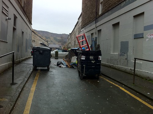
    "there is no good way to link The Meadows to The Innocent Railway path (NCN1)."

    THAT'S SO NOT TRUE!


    There's only some wheelie bins, railings and the 'ye cannae di that' attitude of CEC in the way.

    Posted 13 years ago #
  18. Kirst
    Member

    That photo doesn't show the inevitable pile of broken glass between the bins.

    Posted 13 years ago #
  19. LaidBack
    Member

    In six years of taking people out I've honestly never considered using that alley.

    You just know that's it's wrong on so many levels...

    Better to just put cycle lane through pend at St Patrick's Square. It's wide enough and like most cycling add ons it may not be used all the time but would allow an escape route from Meadows.

    Posted 13 years ago #
  20. chdot
    Admin

    "In six years of taking people out I've honestly never considered using that alley."

    Well clearly in its present state it's not great for ordinary bikes, so recumbents...

    I have used it with groups of kids lots of times.

    Cross main road at the pedestrian lights (dismounted).

    It would be fairly easy to make this into a proper light controlled junction (crossroads with Rankeillor Street) BUT that would require serious pro-cycling commitment from the council!!!

    Posted 13 years ago #
  21. Nelly
    Member

    [although I'm comfortable on the London tube, I have no idea where places are relative to one-another when I'm in London.]

    Dave - A valid point, as anyone who has/does travel in London knows, the Tube map is written for convenience, and does not reflect the real geography of london - in many instances.

    I agree that there are flaws with this - which have been covered in depth in earlier posts - but (indulge me here?) I suspect that TBS are trying to make a simple map for people entirely unfamiliar with Edinburgh, but who are familiar with Tube style maps.

    e.g. Student, going from his flat in leamington to meet friends in gorgie road could use this?

    (OK, there are quicker ways by road, and if you live near the meadows, you clearly cant go anywhere !!)

    It is certainly not perfect, and they really need to improve by putting suggested links between areas - but I think they seem to want to keep it very simple.

    If they are using the £98K on improving signage and the general upkeep of paths, then thats ok by me, even though I will rarely benefit.

    Posted 13 years ago #
  22. LaidBack
    Member

    Nelly 'and if you live near the meadows, you clearly cant go anywhere !!'

    The outer tube map pdf does help to show the gaps at the centre. TBS say that this is version one.

    The tube in London is a bit different... on a bike extra miles mean extra effort as you're doing the driving. Some people do cycle for exercise though so if it helps more to understand what is out there maybe it's good.
    The nightmare scenario is a city where people drive to park and (bike) ride sites as they don't feel able to use the streets. Probably happens already.

    Posted 13 years ago #
  23. 123
    Member

    The new map highlights the prime need for a safe, official, cycling connection between Haymarket and the centre of Edinburgh. Apologies if there already is one of these; as I've lived in Edinburgh all my life it can't be well publicised!

    Posted 13 years ago #
  24. ruggtomcat
    Member

    the center of Edinburgh is not connected to anywhere by a 'safe official cycle-route'

    Posted 13 years ago #
  25. druidh
    Member

    The new map highlights the prime need for a safe, official, cycling connection between Haymarket and the centre of Edinburgh.

    Realistically, where do you think such a thing could be placed? The best cycle route is that broad stretch of tarmac which goes all the way from Haymarket, through West Maitland Street and Shandwick Place and into Princes Street. There's even a special bit for bikes, buses and taxis which the everyday motorist can't use.

    As for "safety", that will be obtained NOT through more dedicated cycle routes but from more cyclists using the roads that already exist.

    SAY NO TO SEGREGATION!!!

    Posted 13 years ago #
  26. Cyclingmollie
    Member

    As for "safety", that will be obtained NOT through more dedicated cycle routes but from more cyclists using the roads that already exist.

    I would go further and add that this is a driver issue and not a cycling issue.

    Posted 13 years ago #
  27. PS
    Member

    Here's a Guardian Local audio article on the Innertube and what it's all about (complete with impromptu Anth interview):Grauniad

    Posted 13 years ago #
  28. recombodna
    Member

    I've just picked up a copy of the innertube map and I have to say as someone who knows edinburgh like the back of my hand I find it very hard to understand. Are the colours of the routes going to correspond with the signage on the actual paths? I don't think a tube style map is the way to go.

    Posted 13 years ago #
  29. wingpig
    Member

    Hmm. Couple of things about the Guardian audio: I happily cycle (and ran, when I lived in Newington) along the Innocent in the dead of night and it's fine, at least between St Leonards and Duddingston Road; I would only go through Bingham with all eyes and ears carefully active. Secondly, which century was that "I'm sure your tea's waiting!" remark from?

    Posted 13 years ago #
  30. cb
    Member

    Nothing to do with cycling (rather, hillwalking), but I thought this map of the Lake District was quite good.

    http://www.tubularfells.com

    Posted 13 years ago #

RSS feed for this topic

Reply

You must log in to post.


Video embedded using Easy Video Embed plugin