CityCyclingEdinburgh Forum » Infrastructure

Routes to/from MidL

(19 posts)

No tags yet.


  1. chdot
    Admin

    There have been various posts that have now overtaken the original thread.

    Discussions about Millerhill - Loanhead options and the possibility of another route -

    POSTED BY JIM -

    "
    This was my, more direct, route south from the city to the Pentlands/Penicuik/Bush Estate that I used as my entry to the Spokes contest in 2009... needless to say I don't know what it would actually cost to enlarge a tunnel under the city bypass, or build a path across that farmland. I think it't be a useful route though: http://tinyurl.com/6bt5aad (pdf)
    "

    Posted 13 years ago #
  2. chdot
    Admin

    @JIM

    Yes that would be a nice new/useful route.

    As you will be aware it is possible to wade with a bike at present, but...

    I think I can safely say that a new tunnel under the bypass is a non-starter - unless of course it was for a road!

    I took a previous CEC Access Officer there to have a look some years ago. We agreed there wasn't much chance of any such 'link' in any near future (and that was then).

    When the Bypass was built quite a few existing roads were cut and mostly not replaced by even a walk/cycle route - Notable exception was Mucklets Road which (now) links Millerhill Yard with QMU. I think Spokes had a fair bit to do with making sure this was provided.

    At the time it was fortunate that the freight line to Bilston Glen Colliery was still in use so that a bridge had to be built. This is now about (?) to become a cycle path.

    What would be relatively easy would be to create a link, from the point where this comes under the bypass, to The Murrays (crossing Lang Loan) and on to the Burdihouse Burn path.

    Posted 13 years ago #
  3. kaputnik
    Moderator

    A fortunate benefit that the Edinburgh, Loanhead & Roslin line brought us was that they built a train-sized underpass for it was incorporated into the City Bypass - even though the line shut very soon after the bypass was constructed. Thankfully they had equally poor planning foresite back then!

    Posted 13 years ago #
  4. slowcoach
    Member

    The works to build this cycle path between Loanhead and Straiton Pond should be finished in a couple of weeks, with a bitmac surface. Unfortunately the site will be untidy for a while with rubbish dumped there and nearby. Midlothian Council got funds from Sustrans and WREN for the works. Links on under the bypass and beyond are outwith Midlothian so that will be 'someone else's problem'.

    Posted 13 years ago #
  5. chdot
    Admin

    "Links on under the bypass and beyond are outwith Midlothian"

    Ah yes, the curious case of the CEC/MidL border.

    So the next bit of line/path is in CEC, but the 'final' piece to Millerhill is back in Midlothian.

    What's the phrase? "Joined-up-thinking", perhaps.

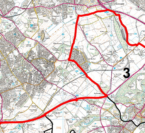
    This map will be subject to the usual copyright conditions.

    Posted 13 years ago #
  6. chdot
    Admin

    "should be finished in a couple of weeks"

    So, how about a CCE trip taking in the Burdiehouse Burn, maybe the lime kilns, a bit of rough to the railway, Straiton Pond, Bilston Glen Viaduct lunch in Roslin(?), back via Penicuik to Dalkeith path?

    Posted 13 years ago #
  7. cb
    Member

    "I think I can safely say that a new tunnel under the bypass is a non-starter"

    They've just run a huge big water pipeline under the bypass (or are in the process of doing so) at approx NT258672, from memory) so it must be possible. Just not for peds/bikes I guess.

    "So, how about a CCE trip"

    Sounds good.

    Posted 13 years ago #
  8. kaputnik
    Moderator

    The route sounds good chdot, can we have some time scrambling around Bilston Glen / Burghlee bings also?

    There may also be some buildings from Ramsey Colliery that are still standing in the centre of Loanhead and the painted "ticket office" sign is still visible on the old Railway Station, but those shouldnt require any more than a stop for a photo on my part and could catch the group up.

    Posted 13 years ago #
  9. kaputnik
    Moderator

    They've just run a huge big water pipeline under the bypass

    Maybe we need a cyclist pipe?

    Posted 13 years ago #
  10. chdot
    Admin

    "There may also be some buildings from Ramsey Colliery"

    Did they make bricks??

    Could detour to colliery bing if we're doing a Nature Reserve tour.

    Posted 13 years ago #
  11. Anonymous

    They've just run a huge big water pipeline under the bypass

    Yes, in fact I think that pipeline follows almost exactly the same route from the Pentlands as my proposed cyclepath. If only there'd been some 'joined up thinking' whilst all those construction workers and heavy machinery were in situ <sigh>

    Posted 13 years ago #
  12. kaputnik
    Moderator

    Did they make bricks??

    No, nearest brickworks were Roslin or Pentland at Straiton and we found both on the pottery beach (well, you did ask!)

    Back on topic, the part of the line where the rails have been lifted that I linked the photo of the is in Edinburgh Council area. I hope this means that the ridiculous situation of the two ends of the route in Midlothian would be completed and Edinburgh's missing link would be left in the middle will be avoided.

    Posted 13 years ago #
  13. Nelly
    Member

    Did this a couple of weeks ago, think thats why my road bike is now in the shop getting a new hub due to all the grit and junk on the roads. It was also during the resurfacing of the dual carriageway out to loanhead, so the surface there left a lot to be desired, ho hum..............
    Grange to Temple Midlothian and back

    Posted 13 years ago #
  14. Anonymous

    Yes, the pipeline route (pdf) would be an ideal bike path!

    Posted 13 years ago #
  15. PS
    Member

    @Nelly Good News! I cycled out to the Granites last Sunday taking the NCN 1 route through Carrington. The down and up between Carrington and the B6372 had just been resurfaced. That used to be a shocking piece of road, a really rough surface on a fast descent that felt decidedly dodgy. Now it is silky smooth tarmac(except for the bit over the bridge at the bottom for some reason).

    There has been some improvement to the NCN1 a wee bit further south as well (although this have happened last year - I can't remember). What used to be a uniformally awful surface past the old limeworks (I'm sure K will correct me if that's not what they were ;-)) and the current quarry has been resurfaced in places (again, no idea why it hasn't all been done).

    Unfortunately, the road at the farm at Middleton is covered in mud (at least I hope that's what it was), but there's not much that can be done about that, short of paying the farmer to hose it down after every sortie. It was so bad I had to stop at the bottom of the hill to scrape the mud from under my mudguards to prevent them acting as a massive break on the ride up the Granites...

    So pleased was I with these new bit of smooth tarmac (there are few things better on a road bike, I hope you all agree) that I'm contemplating starting a new thread so we can share (and even map, if I can get the IT skills) sightings of sections of fresh tarmac for those long summer rides. I may get on to this later...

    Posted 13 years ago #
  16. slowcoach
    Member

    There seem to be more works planned in that area soon, so watch out for road closures
    Bridges sometimes have to be treated seperately to avoid damaging the structure beneath the surface. Maybe the sections left untreated weren't bad enough to justify work this time.
    Depending on how the mud (?) got onto the road the
    farmer may have a legal duty to clean it up. If it is a problem it might be worth reporting this.

    Posted 13 years ago #
  17. Nelly
    Member

    @PS - thanks very much, did not see your post before today, but I appear to have been staling your routes !

    Happened to be out that direction today, starting at middleton - left the car at middleton - my mate was navigating, took a wrong turn, and we crossed that very spot at carrington - better, as you said.

    Regarding NCN1, we were also on that today on our last 20 miles or so, Traquair to the A7, and its all pretty good - but the last few miles down to the A7 are magnificent !

    Tres tired now, beer and a snooze later.......

    Posted 13 years ago #
  18. amir
    Member

    PS - thanks for that news. I have used these routes a lot being based in Eskbank but haven't been for a while due to road surface. I think that the Bethany Sportive has been rerouted this year along the A7 to avoid these problems!

    Posted 13 years ago #
  19. chdot
    Admin

    Thought it worth reviving this thread.

    Been some discussion on other thread which included routes to Midlothian.

    Latest on continuing railway path from Loanhead on Edinburgh side of Boundary -

    "
    We have undertaken an initial feasibility study for routes between
    Loanhead and the Gilmerton area - part funded by Sustrans. We will look
    to take this design work further this year with a view to potential
    implementation in 2013-14.

    "

    Posted 12 years ago #

RSS feed for this topic

Reply

You must log in to post.


Video embedded using Easy Video Embed plugin