
Network Rail, the unstoppable Godzilla! Even the Venerable Hinds couldn't defend us against such bridge chomping determination...
(Jan 19 0800 till July 19 1800).
CityCyclingEdinburgh Forum » Infrastructure
Russell Road to shut(?)
(214 posts)-
Posted 11 years ago #
-
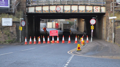
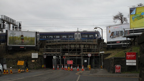
OMD Russell Road carriageway shut to 'wheeled carriages'! This morning!
Posted 11 years ago # -
I came through just after 8 this morning. Road coned off at each end of the railway and tram bridges, but was still able to use the shared section of pavement under the bridges without issue. No sign of workmen etc.
Posted 11 years ago # -
Russell Road appears to be open again now, though lots of cones and signage lying around. Weird...
Posted 11 years ago # -
Either someone has taken matters into their own hands or the contractors have only just been told that the work is cancelled.
Posted 11 years ago # -
was still able to use the shared section of pavement
This is the only sign left showing the footpath as shared. All others disappeared during the resurfacing of Russel Road last year.
 140701151430IMG_0935 by fountainbridge, on Flickr
Posted 11 years ago #
140701151430IMG_0935 by fountainbridge, on Flickr
Posted 11 years ago # -
Well at 2:30pm it was still definitely open. This really is a bit of a shambles. It if is a symptom of the poor relationship between Network Rail and the Council (see the Waverley Station debacle) they really should be ashamed of themselves.
Posted 11 years ago # -
By the sounds of it Network Rail emailed the council, council responded "ok", but Network Rail didn't raise the official paper work. I'm guessing NR have staff standing around doing nothing at the moment given this postponement.
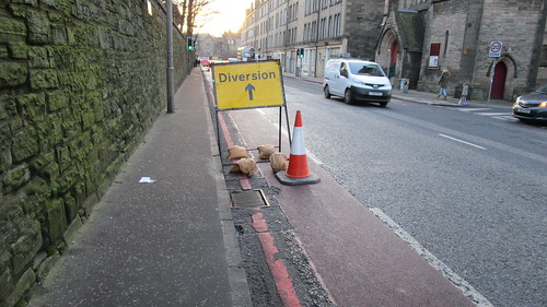
On a separate issue I noticed the diversion signs propped up on Dalry Road pavement. If the signs were erected on the path they'd take up the full width. If erected on the road they'd take up the full width of the bike lane.
If they're erected on the footpath expect them to be relocated in to the bike lane sharpish.
Posted 11 years ago # -
Russell Road shut this morning at the bridges - Contractors unloading portacabins, so looks like they mean business. The shared path was open. Quite a few cars ignoring the roads closed signs coming from Gorgie and having to turn back. I suppose this is to be expected after the false start on Mon.
Posted 11 years ago # -
@Basecut never underestimate the determination of the Edinburgh vehicularist to "know better" than all the warning signs and plow on regardless until they come up against an impenitrable wall of Heras fencing.
Posted 11 years ago # -
definitely more traffic going past my house in the night than usual (along roseburn street) suppose that'll happen.
Posted 11 years ago # -
Edinburgh vehicularist to "know better" than all the warning signs
and then investigate said wall to determine level of impenetrability.
Posted 11 years ago # -
Dalry Road was solid this morning, merrily zipped past over a hundred vehicles towards Haymarket tra laa laa laa laaaaa
Sadly I can't go home via the WoL path now. Is the bike lane open under the bridges?Posted 11 years ago # -
It's debatable if the "bike lane" still exists or not seeing as all but one of the signs have been removed. I expect more barriers will appear in the next few days.
 150122154701IMG_0110 by fountainbridge, on Flickr
The bike lane on Dalry road westbound now blocked with signs. If the fairies do visit and move the signs, I do hope they don't block the footpath.
 150122154253IMG_0109 by fountainbridge, on Flickr
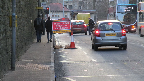 150122154234IMG_0108 by fountainbridge, on Flickr
Posted 11 years ago #
150122154234IMG_0108 by fountainbridge, on Flickr
Posted 11 years ago # -
I had a look this evening. Early days, but right now the arrangement of traffic cones and Portakabins (etc.) means there is no dropped kerb access from Russell Road eastbound onto the zigzag path up to NCN1. Here: http://osm.org/go/evfLCr_tA?m=
Posted 11 years ago # -
Much though I don't like the location of those signs on Dalry Road, I agree that they are better there than on the pavement (and even the silliest driver is hardly going to tell you to get in the cycle lane when there's a great big sign in it).
(I get into the right hand lane to go to Gorgie Road at that point anyway, so it makes no difference to me.)
Posted 11 years ago # -
I hope the council will make a deduction from their "money spent on cycling" column to reflect the fact that maintaining the edge 1.5m of that road isn't in anyway beneficial to cyclist for the next 6 months.
Posted 11 years ago # -
The road is closed for 6 months is it not? It shouldn't be outwith the powers of the council to mount a temporary sign on one of the lamp posts, thereby restricting neither the road, the cycle lane nor the pavement.
Posted 11 years ago # -
Heading from the NEPN - Russell Rd - Ardmillan was like Wacky races last night. A steady stream of people ignoring the roads closed signs and having to turn back at the entrance to the Industrial estate - their presence encouraged more cars that the road was actually open. Traffic very heavy on Dalry Road and those diversion signs are quite a problem when the traffic is heavy as progress can only be made up the right side which is dicey on that stretch at the best of times and particulary when lots of them have had to turn back/been defeated by the closure. I'm sure it will all settle down.
Posted 11 years ago # -
I've had words with South West Team about the signs for Grosvenor Crescent. The road is shut northbound for a good 18 months but still the temporary signs, which normally blow over every few days. Absolutely no interest.
Until Lothian Busses complain about delays on Dalry and Gorgie roads nothing will happen.
Posted 11 years ago # -
Created an photo album of pics taken, including some from yesterday
https://flic.kr/s/aHsk7YBKMaAlso asked West Team for clarification of pavement shared space. I have a hunch that footpath under the tram bridge is no longer wide enough for a shared path. Is there a min width for a pavement to be considered for shared use? (I know canal path is narrower and is still shared)
Posted 11 years ago # -
South West Team have confirmed the path is still shared and will reinstate the signs.
Edinburgh Trams removed them, but the replacements will come out of Sout west teams budget.
Posted 11 years ago # -
Thanks for chasing this up, Fountainbridge! Good work - would be nice to think that some aspects of the shared use pavement could be improved - or the route is less of an attractive rat run.
Posted 11 years ago # -
Thanks to SRD I've spent rather too many hours playing with the Edinburgh council atlas and found the proposed route from Russell Road to the Canal. Seems a very tortious route.
My route would be along Russell Road (could be segregated and still have room for parked cars), through Murieston Road (segregated in one way section), then up Henderson Terrace, Ardmillan Place, then on to the old railway line (it's looking for a real use), then up Harrison Place and up through Harrison Prak (keeping your speed down)
Red is the planned route, blue would be my slight diversion, Purple would be my route
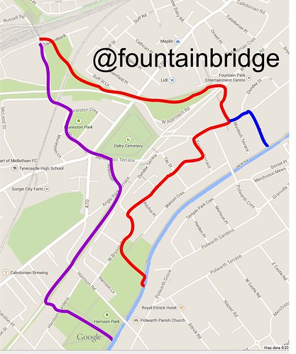 cyclemap by fountainbridge, on Flickr
Both pavements are still open by the way
 150203142721IMG_0222 by fountainbridge, on Flickr
Posted 11 years ago #
150203142721IMG_0222 by fountainbridge, on Flickr
Posted 11 years ago # -
Yes, I meant to post that you can get through there on a bike except they have not provided any ramps so you have to be capable of getting your bike/buggy/wheelchair up and down the kerbs.
(I'm fairly sure they put in ramps when the road was closed before. I don't suppose they were very good ramps, but I don't remember having to lift my bike on and off kerbs. Or maybe they kept a bit of the road open.)
Posted 11 years ago # -
I'm sure that Russell Road-to-Canal route options could do with its own thread, but I notice on the Council atlas that the Gibson Terrace option (fountainbridge's blue bit) is marked with a thin red line.
There are other thin red lines on the map. mainly corresponding to planned cycle connections, e.g. Lochrin Place. The lines appear to be labelled "un".
Anyone know what "un" means, I can't see anything in the key?
Posted 11 years ago # -
The PoP feeder ride I was on got to the canal/Fountainbridge from Dalry Road by using the path which goes up behind Lidl and comes out at Fountain Park. Never knew about it until then!
Posted 11 years ago # -
Thanks Fountainbridge for City of Edinbvrgh Covncil Atlas link. Well worth having a look at.
EDINBVRGH COVNCIL'S ATLAS as suggested by FountainbridgeLooks like they want to add a bike bridge over Dalry Road. Your alternative route is interesting. Never really thought about Ardmillan Place. Didn't know it existed really!
LB tours take the West Bryson road cut off from canal - or go round by Merchiston Avenue depending on time of day.
Posted 11 years ago # -
Looks like they want to add a bike bridge over Dalry Road
Are you dreaming?
Knowing CEC, cyclists travelling south will have to:
- descend to Dalry Rd
- navigate some awkward 90 degree bends on shared use pavement
- press a button to wait for the more important motorists before crossing Dalry Rd
- then climb up toward the Western Approach Rd (as they currently do)
- then descend down to Telfer subway
- navigate an awkward chicane complete with Brompton wheel swallowing gutter
- climb up toward Dundee St using the narrow zigzag, complete with blind corners
- continue climbing over 'ramped' steps
- Press the button again to cross Dundee St.
- Do some more shared use pavement stuff, etc. etc.Whereas the more important motorists already have their 'at grade' bridge across Dalry Rd (on the WAR).
Posted 11 years ago #
Reply »
You must log in to post.
 posts
posts
