CityCyclingEdinburgh Forum » Infrastructure

Cycle access to/from The Gyle

(12 posts)

  1. Arellcat
    Moderator

    Is it me or is The Gyle shopping sprall remarkably badly designed for cyclists? I've been there a few times on my bike, but not exploring enough to know whether there is more than the single bike rack next to the bus terminus. And it's such a complex collection of 'sort-of' bike paths to get there that someone less happy with the roads might give up altogether and go somewhere easier.

    What would be the most convenient route to get from there to St John's Road/Corstorphine Road heading east? Until today I never knew there was a path to South Gyle Station, but that still leaves the roundabout at PC World, or the busy stretch between Tesco and PC World. Maybe Manse Road is the key?

    Posted 14 years ago #
  2. chdot
    Admin

    "is The Gyle shopping sprall remarkably badly designed"

    yes

    "for cyclists"

    yes

    "Until today I never knew there was a path to South Gyle Station"

    Yep, gave up trying to get it properly signed/highlighted years ago.

    http://www.mapmyfitness.com/ride/united-kingdom/edinburgh/211496400

    "What would be the most convenient route to get from there to St John's Road/Corstorphine Road heading east?"

    A nice footbridge to Gyle Park - but there's (always) "no money".

    Posted 14 years ago #
  3. chdot
    Admin

    Of course you know it's possible to get from Haymarket to The Gyle without going on Corstorphine Road.

    http://www.mapmyfitness.com/ride/united-kingdom/edinburgh,-scotland/197178390

    Bits of it are even signposted.

    Posted 14 years ago #
  4. Arellcat
    Moderator

    Yes, that's the path I found on my Spokes map. I like railways a lot but sometimes they do get in the way.

    A wee foot/bike bridge would be ideal; I thought there might be an underpass somewhere along there but it looks as though they thought about it and then didn't bother.

    Edit: I haven't tried the Balgreen/Roseburn section before either - too busy trying to be a tough road cyclist I guess. I might just give it a whirl!

    Posted 14 years ago #
  5. chdot
    Admin

    "I thought there might be an underpass somewhere along there"

    There is!!

    But not usable - fenced off.

    'Too difficult to do things under/over/near live railway' - haven't been for a while can't remember whether it would be possible to use standing up, pretty sure would need some excavation for public use.

    'Why is it there?'

    Ever heard of The Stank?

    Posted 14 years ago #
  6. Arellcat
    Moderator

    Ever heard of The Stank?

    Yes, it's marked on my 1960 Edinburgh map, before they covered the whole place in tarmac and concrete. I'll have a poke around.

    Posted 14 years ago #
  7. chdot
    Admin

    "Yes, it's marked on my 1960 Edinburgh map"

    Indeed

    It's quite fun to follow the route (not possible to do completely at various points)

    The exit is visible near the ice rink and there are trees (mostly willow and poplar) on what used to be the banks. (Before my time)

    Surprisingly few references to 'recent history'

    http://13edinburgh.boys-brigade.org.uk/Village.html

    "Notable examples of watercourses which are extensively
    culverted include:

    • In Edinburgh, the Jordan Burn at Morningside, the Stank at Corstorphine and Carricknowe, the Murray Burn at Wester Hailes, the Braid Burn at Cameron Toll and sections of the Gogar Burn at South Gyle"

    http://www.sepa.org.uk/water/water_publications/idoc.ashx?docid=6eea8d09-4d69-427e-8e16-c3dc0418ff19&version=-1

    Posted 14 years ago #
  8. gembo
    Member

    In west coast parlance A Stank is a drain or possibly a drain covering of heavy Iron grill nature. I was once informed by group of lads on the Clockwork Orange that they were The Govan Stank Lifters,

    I find it best to avoid The Gyle Shopping Centre but have been to it and it is badly designed for all parties.

    Posted 14 years ago #
  9. SRD
    Moderator

    The 'new' Edinburgh West royal mail delivery office out there is almost totally inaccessible on foot/bus. haven't tried cycling there [I just avoid it now], but it has put me off everything in an around the Gyle.

    [my first and last expedition there famously ended with me -- after long time in queue where there was no room to queue -- hoisting stinky baby on counter and saying 'of course i'll wait to see your line manager if he can't come now...is there somewhere I can change this nappy?' Never did see the manager, but I got my parcel!]

    Posted 14 years ago #
  10. Arellcat
    Moderator

    Despite taking my Spokes map with me, I was obviously too busy pedalling to actually bother looking at it, and took a wrong turn or two. :-) While I was trying to get out of Broomhall Drive I then forgot about the Dovecot Rd/Meadowhouse Rd cut-through, and I ended up on the main road after all.

    http://bikeroutetoaster.com/Course.aspx?course=105900

    Not an entirely bad route I guess. The path to South Gyle station is good, but as Chris said, you'd never know about it unless you'd been shown. Crossing Meadow Place Road is a bit of a pain without a lot of doublebacking, but if there's a toucan crossing along there, I didn't see it!

    Posted 14 years ago #
  11. chdot
    Admin

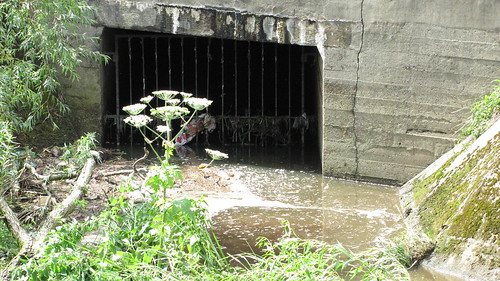
    Where The Stank meets the WoL

    Posted 12 years ago #
  12. DaveC
    Member

    I regularly travel into Edinburgh through South Gyle St and have noticed that the gate access from The North side of the platform to the Gym, is oftern closed and locked outside normal working hours.

    Posted 12 years ago #

RSS feed for this topic

Reply

You must log in to post.


Video embedded using Easy Video Embed plugin