CityCyclingEdinburgh Forum » Infrastructure

Cycling Infrastructure Tour

(36 posts)
  • Started 12 years ago by Kim
  • Latest reply from ExcitableBoy

No tags yet.


  1. Kim
    Member

    The Go Bike! Strathclyde Cycle Campaign has been organising a Glasgow Cycling Infrastructure Tour. Following similar infrastructure safaris in London and Newcastle, the Glasgow Cycling Forum in conjunction with Go Bike organised its own ride for Councillors and Council Officers, to show off the variable quality of facilities they are responsible for providing.

    If you were organising a similar tour in Edinburgh, where would it go?

    Posted 12 years ago #
  2. I presume we want good and bad to show how it can be done against how it is (more often) actually done?

    Quick starter (list first then plan route?)

    Good

    Innocent path
    Trinity path
    Scotland Street Tunnel

    Bad

    Missoni Lane
    Haymarket

    Posted 12 years ago #
  3. kaputnik
    Moderator

    Confuso-junction at bottom of Argyle Place.

    Bollard/gate across the top of Innocent Tunnel.

    Lack of dropped kerb at top of MMW

    Mound (or lack of) cycle lanes

    Red-painted cycle lanes at top of Marchmont Road, with no yellow lines so permanenetly full of parked cars.

    Melville Drive on weekend / out of hours

    Innaccessible ASL feeder lane on Portobello High Street at Harry Lauder Road / Portobello Road / King's Road junction

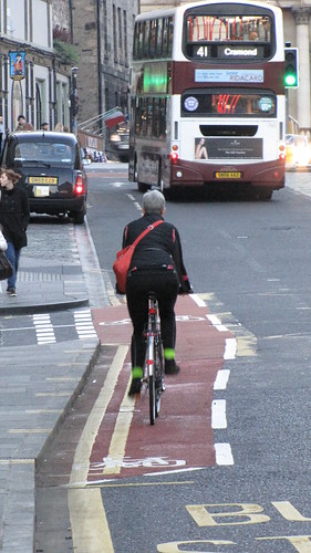
    Marchmont Road cycle lanes (virtually invisible now) and lack of feeder lane at bottom to left turn onto Melville Drive.

    I could go on (and I might, later!)

    Posted 12 years ago #
  4. SRD
    Moderator

    Bad - Telfer subway and bollards which don't let trailer through at the Dalry end, and poor road joining at the Fountainpark end.

    Posted 12 years ago #
  5. chdot
    Admin

    As above - http://www.gobike.org/gcf-tour.php

    Spokes has done this a few times.

    Last one included Missoni.

    Long list (good and bad) + route sounds good.

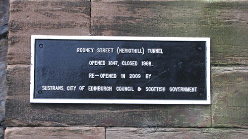
    Only noticed this sign yesterday -

    Posted 12 years ago #
  6. kaputnik
    Moderator

    Oh, on the subject of Missoni Lane, I walked past on Friday night and with the resurfacing in the area, the red feeder lane has now extended back across the mouth of Victoria Street almost to (I think) Central Library.

    It's still the same road arrangement though, so not sure how this helps if lane is still permanently full of cars or encroached on by taxis / vehicles dropping off outside Missoni.

    Posted 12 years ago #
  7. wingpig
    Member

    A selection of the paths/'facilities' spoilt by street furniture/parking/uselessness as depicted in the "barriers to cycling in Edinburgh" Flickr group. You'd definitely want to include going through Haymarket in a couple of directions and some of the Torphichen/Morrison/Fountainbridge area no-exception one-way kerfuffle. Compare the red-paint-having Haymarket with the red-paint-free Leith Street and London Road roundabouts. Marchmont Road's parking extension-zone bike path and the Argyle Place Thing. The lumpy surface of North Meadow Walk. The mess at the Roseburn end of the NEPN and the Balgreen exit of the Carrick Knowe path. Contrasted to the rest of the NEPN, the usable bits of the WoL, the Innocent and some of the handier cycle-compatible cuts-through it would demonstrate the difference between useful hassle-reducing facilities and box-ticking.

    Posted 12 years ago #
  8. kaputnik
    Moderator

    Oh and for "good infrastrucure" - Porty Prom :)

    Oh and for "bad infrastructure" - abrupt and confusing termination of Silverknowes Prom > Granton extension that forces you to either bump off pavement, or if you want to use the dropped kerb, navigate through the barriers then enter facing INTO the traffic rather than in same direction.

    Posted 12 years ago #
  9. SRD
    Moderator

    North Meadow Walk - especially at night is very exciting. I stopped twice the other night just on the east-most section, thinking I had either run over something or had something fall off the bike.

    Posted 12 years ago #
  10. kaputnik
    Moderator

    @chdot I noticed those signs recently too. There is another one at the other portal of the tunnel.

    Posted 12 years ago #
  11. North St Andrew Street as well. Still a contractors' car park, including the pavement cycle lane. The crossing is still in operation from Dublin Street with the lovely green and red bicycles, but once you're across Queen Street there's nowhere to go!

    Posted 12 years ago #
  12. amir
    Member

    Loads of on street cycle lanes with difficult surfaces (basically because it's the gutter?)

    Posted 12 years ago #
  13. Smudge
    Member

    Bad:
    Road surfaces destroyed by buses/made dangerous by parking - Haymarket out to the Diggers.

    "Resurfacing" turning a slightly muddy cycle path into an energy sapping (equally manky) sludge - Old Railway from the canal out past Colinton :-/

    Good:
    Tarmac and (hun landing) lights along canalside, actually very nice to ride at night (though it could be improved at bridges!)

    Posted 12 years ago #
  14. crowriver
    Member

    Good:

    Five ways junction area
    Lochend path (the bit that's been tarmacced)
    Holyrood Park going South uphill (from zebra crossing onwards)

    Bad:

    Leith Walk (just about anywhere)
    Link route between Granton and Silverknowes path (chicanes, bumpy, overgrown, ends with a gap in a fence, busy road to cross then poorly designed access through car parking)
    Lochend path (Seafield steps access)
    Holyrood Park (going East from zebra crossing; also poorly designed access at top of South end of Queen's Drive)
    Pelican crossing at end of Fishwives Causeway (big sign showing cycle route acts as a chicane when trying to go to crossing, which is not aligned with causeway but left; steep incline of dropped kerb tries to tip you off your bike when reaching button; sequence very slow, favours motorist with long wait for cyclists/pedestrians)

    Posted 12 years ago #
  15. SRD
    Moderator

    The link between valleyfield st and the meadows, where in the space of about 10 metres, the cycle path shifts from the lefthand side of the path to the right hand side and then back to the left once we cross melville Drive

    Posted 12 years ago #
  16. kaputnik
    Moderator

    @SRD or from right to left to right in the opposite direction! Then presents you with a no entry road (which it should be perfectly feasible to make 2-way for cyclsits)

    A lot of the ones I've suggested so far are confusing and inconvenient.

    For downright dangerous, I'd put the ASL opposite King's Theatre at end of Lower Gilmore Place. If you sit in it to turn right, buses coming from Tollcross and making a left right at King's clip the corner of the ASL reservoir quite significantly. If you were waiting far out on the right to make a right turn you can be in serious danger of being mushed by the bus.

    There's similar one on Gorgie Road at junction with Roberston Ave / Wheatfield with a similar problem caused by buses turning out of Robertson Avenue or Grain lorries turning out of Wheatfield from the distillery, and they have set the ASL reservoir back by about 15 feet to keep you in a safer zone (although still very intimdating to be sat stationary in the box with a lorry or bus swinging towards you)

    Posted 12 years ago #
  17. SRD
    Moderator

    @kaputnik. true, but since Tarvit street makes more sense when heading for Gilmore place, and Brunstfield/Morningside is better reached across the meadows/links, I tend not to want to go that direction. Would be handy for co-op runs and Lupe Pintos, I suppose!

    Posted 12 years ago #
  18. Arellcat
    Moderator

    Keep them coming, folks!

    Gugol Map of poor (and good) infrastructure in Edinburgh

    Posted 12 years ago #
  19. chdot
    Admin

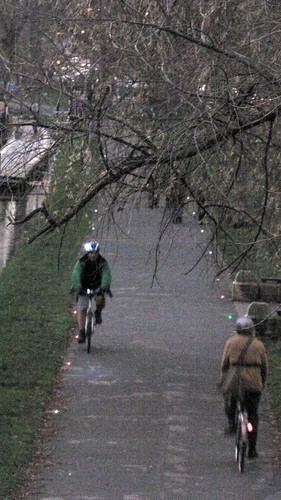
    "lights along canalside"

    Last night -

    (this is the digitally lightened version)

    WHY do people gravitate to the 'wrong' side??

    Posted 12 years ago #
  20. Arellcat
    Moderator

    I think people habitually walk on the side of a path that's furthest from perceived danger. This becomes the side away from the canal, or the western side of the path through Braidburn Valley.

    Posted 12 years ago #
  21. SRD
    Moderator

    Cycled the canal last night in the dark for the first time since lights went in. really quite nice.

    Great map arellcat!

    Posted 12 years ago #
  22. cb
    Member

    Some more bad:

    - NCR link between the Innocent and the Meadows. Stipid fenced off bit at the end of Gifford Park would be a good place for the map pin.

    - Stupid bumpy ramp by the Telfer subway (well, it's ok going downhill)

    - Stupid zigzag slope by the W. Approach Road crossing.

    Posted 12 years ago #
  23. wingpig
    Member

    Bruntsfield Place (uphill/southbound approaching the Looming Church of St. Barclay) and Holyrood Road (uphill/westbound just before the Moray House crossing) have some good examples of cycle-lane-feeds-directly-into-pinch-point.

    Turning-into-Seafield-Road-from-King's-Road-or-Porty-High-Street has nice big fresh advanced stop zones unfortunately coupled with traffic lights which don't detect lone cyclists (unless they've since been fixed after I reported them). The mandatory leave-the-road (for cyclists, teensy motorbikes and horses) to stop them cluttering up the West Approach Road (westbound) any further than Canning Street similarly doesn't detect solo bicycles (unless it's also been fixed since being reported).

    Considering the proximity to the end of the cycle-compatible WoL path, the almost paint-free junction of The Shore/Henderson Gardens/Sandport Bridge must be particularly dispiriting to people not used to it. Similarly, the nearby one-way warren around Tollbooth Wynd/Water St makes getting to the WoL from the direction of Leith Links less pleasant than it could be.

    Posted 12 years ago #
  24. crowriver
    Member

    Great map, Arelicat. I'm adding them directly on Gugol now...

    Posted 12 years ago #
  25. Melville Drive in general being parked on at the weekends.

    And in a similar, even more annoying, way - Ferry Road - the cycle lane is an official car park for sporting events at the playing fields.

    Eyre Place contraflow is awkward to exit at the lights end.

    Posted 12 years ago #
  26. kaputnik
    Moderator

    Yes excellent map A-cat, I shall try add a few more of my own this evening. I have a feeling they may mainly be red!

    I believe this is known in the future as "crowdsourcing" or something.

    Posted 12 years ago #
  27. Kirst
    Member

    Chicanes on the Innocent just east of Duddingston Road West are painted black and are very difficult to see in the dark if the streetlights nearby are out. They would benefit from something reflective. Chicanes on the Embra side of the Hope Lane bridge are awkward.

    Posted 12 years ago #
  28. steveo
    Member

    The chicanes on the canal could do with some reflectives so that they are a bit more visible.

    Posted 12 years ago #
  29. SRD
    Moderator

    chicanes past the ring road don't fit tandems!

    Posted 12 years ago #
  30. chdot
    Admin

    "Oh, on the subject of Missoni Lane, I walked past on Friday night and with the resurfacing in the area, the red feeder lane has now extended back across the mouth of Victoria Street almost to (I think) Central Library."


    New red by chdot, on Flickr

    Posted 12 years ago #

RSS feed for this topic

Reply »

You must log in to post.


Video embedded using Easy Video Embed plugin