CityCyclingEdinburgh Forum » Infrastructure

NCN 'missing link' - your thoughts

(26 posts)
  • Started 12 years ago by LaidBack
  • Latest reply from chdot
  • poll: Which route would you try to improve - if any?
    Route A - via St Patrick's Sq with toucan crossing : (3 votes)
    21 %
    Route B - improving existing Rankeilor St route : (5 votes)
    36 %
    Route C - improving on street route : (5 votes)
    36 %
    Route D - light contolled r/h turn into the Causey : (1 votes)
    7 %

No tags yet.


  1. LaidBack
    Member


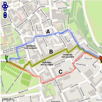
    Three routes on missing NCN 1 by LaidBackBikes, on Flickr

    All routes have to cross the A7 somehow...
    Although many here would just take the road we know that younger and less experienced riders might be encouraged to cycle from Marchmont to the Innocent if this 'flagship' route was improved.

    Route A is the one I use as it seems to have more space / less risky. Light crossings are available on all sections except the one at the end of the very spacious Buccleuch St is not aligned. This is something I think could be done relatively cheaply - similar example of box junction beside a pedestrian crossing can be found at Nicolson Square. At moment you have to walk round railings.

    Route B is the one currently recommended on CycleStreets. This features wheelie bins, railings and a non-aligned crossing.

    Route C is one I use myself but unsuitable for leading less confident cyclists.

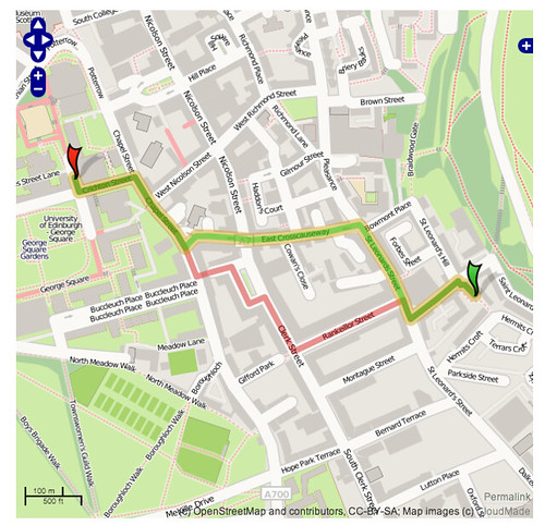
    Route D Cross Causeway is the other route. This has the technical problem of doing a right turn on a corner. Ok in reverse direction which I use at present. Causey is also a one way street at present. Residents want it re-developed - covered elsewhere on forum in the past.

    Posted 12 years ago #
  2. custard
    Member

    I take route C on my commute home

    Posted 12 years ago #
  3. Min
    Member

    I also use C. I wouldn't touch B with a bargepole. Am not familiar with A but I would just use St Leonards Street since it is wide in the Southerly direction anyway and avoids the horrible cobbles. There tends to be parked cars on the other side which would be stressful to some people though..

    Posted 12 years ago #
  4. LivM
    Member

    Route B is horrid. Esp the final blind right turn onto Causewayside. I can't believe that it's the official Route 1. A or at-a-pinch-with-a-right-filter-C would be much better as the official route, I think.

    Posted 12 years ago #
  5. Min
    Member

    I feel pretty sure that B could be improved to an acceptable level by aligning the crossings and removing the railings/wheelie bins/layer of broken glass etc. It is the most direct which I know is very unusual in a cycle route setting!

    Posted 12 years ago #
  6. LaidBack
    Member

    All the non C routes feature cobbles. I'm thinking though of the family group cycling to Holyrood Park. These would be people that are coming back to bikes and are happy to use any marked route as long as crossings are in place.

    Congested squeeze points where you have to push your bikes (and trailers) beside railings are a turn off. Also produces conflicts between cyclists and pedestrians.

    A good cycle and walking route should be direct and not polluted. Obstacles like railings and street clutter should be taken down and sold for scrap.

    Posted 12 years ago #
  7. PS
    Member

    I'd say B is the way to go with an aligned crossing at Clerk St and a light-controlled crossing at Causewayside. Cobbles are neither here nor there as long they are reasonably maintained. Even if they're not, they're fun for short blasts anyway.

    Posted 12 years ago #
  8. Dave
    Member

    I never really need to ride this route, but if I did I would do B going east (despite the awful setup at Clerk St) since it's the most direct.

    All it needs is to be opened up and the existing crossing moved north (with a large yellow hatched area put in place, as at Nic Sq).

    Posted 12 years ago #
  9. Its_Me_Knees
    Member

    My new commute (4 weeks hence) will require me to go from the Haymarket end of the Roseburn path to the new Royal Infirmary, and I'll need to find a preferred route from the North side of the Meadows (and maybe even PY on a Friday morning :-)...) onto the Dalkeith Road. So I'll be watching this feedback with interest.

    Posted 12 years ago #
  10. Dave
    Member

    The CycleStreets quietest suggestion, for once, is broadly how I would go. Any extra distance is small over the pure road route, but you'll enjoy a considerable distance on cut-throughs and paths...

    Posted 12 years ago #
  11. Kirst
    Member

    Living where I do (by the Engine Shed) it's quicker for me to bump along the St Leonards Lane cobbled potholes, Rankeillor Street, walk across the main road then get back on the bike, slalom down Gifford Park and then take my life in my hands trying to get out of the bottom without being squashed by a no42 coming around the blind corner. But it's not pleasant. So I'd quite like that to be improved please.

    Posted 12 years ago #
  12. Arellcat
    Moderator

    I think Gifford Park is awful, and St Patrick Sq still leaves you with a problem crossing Clerk St. The more I look at it the more I wonder if West and East Crosscauseway plus Bowmont Place is the key.

    If you close WCC to motor vehicles with bollards at the eastern end, the only issue is getting in and out at the western end, and since we can't demolish the church or cut across the graveyard we need an alternative. Windmill St faces West Nicolson St, so by moving the Crichton St pedestrian crossing south, that junction would become properly signalised to allow a safe right turn for eastbound cyclists, with a safe left turn into WCC.

    By then modifying the WCC traffic island area to incorporate a short duration signalised exit lane for right turning cyclists (same as Langton Rd by KB) this allows a later safe left turn into Crichton St for George Sq (so long as CEC fixed the cobbles!). Confident cyclists can still do right turns into Buccleuch St or WCC or Boroughloch or wherever they like.

    Posted 12 years ago #
  13. wingpig
    Member

    Bowmont Place is a lot better than it was since the cobbles were relaid a few years ago but St. Leonard's Hill is fairly unfriendly if there are any other vehicles wanting to get past all the parked cars. If going Innocent-to-Meadows I'd usually go Hermit's Croft/Bernard Terrace (rather than bother with the blind/bush-infested corner by the Engine Shed, the kerb by the Engine Shed, the parking on St. Leonard's Hill, the cobbobbles of Bowmont Place, the daft pavement thing to get to the ped crossing across the Pleasance and the cobbles of West Crosscauseway and the right-turn to either Meadow Lane or Boroughloch or Buccleuch Place, if the other cobbles weren't cobbly enough). Going Meadows-to-Innocent I usually choose Route E: head south down MMW after getting annoyed by the state of NMW, go over the Argyle Place Thing, Melville Terrace it eastwards then Preston Street across to Scottish Widows, turning left and hooking round to the tunnel.

    Posted 12 years ago #
  14. LaidBack
    Member

    Thanks for input so far. Imagine if key cycle routes were actually built to the demands of cyclists?!

    This survey shows that the route which has the least amount of assisted toucan crossings is in fact the one that most people would use.

    Instead we have the Cross Causeway route which has two new toucans in the last few years. To be fair if we are to hit the target the CEC should improve both routes A and B. A major shame is the lack of aligned crossing which could have been worked out before.
    My own feeling is that route B will hit a big NIMBY opposition - that is residents there will not want access to Rankeilor Street altered.
    Routes which involve right hand turns or any mixing with bus routes are not going to be attractive to newcomers unless controlled by lights. Route B has two right hand turns which make it unsuitable for anything less than experienced cyclists. Even with Gifford park into Rankeilor necoming a crossroads it will still need money spent.

    That was one reason I wondered whether the potentially quieter crossing into St Patricks Square was a contender - although it would need an inventive way to get over the A7 Nicholson St/Clerk St. I would just yellow box a big area and move traffic out to allow diagonal crossing by bike. Is it legal... sure it could be arranged. Closer to the Uni Buccleuch St is massive and could easily have a cycle lane leading directly through. Uni is also very pro-bike.

    I also do a route check to see if Cycle Streets would ever recommend the route that involves the toucan crossings on A. Quite interesting how the infrastructure doesn't match suggested routes. I do like Cycle Streets but linking across A7 is an odd one for it - and everyone else coming into the city. Hence the reason I think it needs sorting soon.
    Cross town routes which avoid cycling along with traffic will be attractive to many newcomers and families. All part of making the most of what we've got. Direct routes are also attractive to pedestrians who at moment are fenced in. So look at these as green corridors (with a few wheelie bins!)


    St Leonards to Infomatics by LaidBackBikes, on Flickr


    ST PATRICKS SQUARE PEND 2 by LaidBackBikes, on Flickr

    Posted 12 years ago #
  15. chdot
    Admin

    A response from CEC -

    "
    reassuring that the most popular route is the one we are designing up! (with the exception that we are avoiding Boroughloch).

    Route A is an interesting alternative but relies on a lot of setted streets (albeit these look in good condition in Streetview).

    Some other interesting ideas and a connection through St.Partick Square is worth consideration for a future scheme although we are prioritising the routes in the ATAP Family Network.

    "

    Posted 12 years ago #
  16. Min
    Member

    Which is the "most popular route"?

    Posted 12 years ago #
  17. chdot
    Admin

    "Which is the "most popular route"?

    Presume means as in poll at top - currently B.

    Posted 12 years ago #
  18. wingpig
    Member

    Currently B: So they're shifting the pedestrian crossing over, getting rid of the barrier, shifting the bins (and the stuff which should be in the bins but is generally found lying somewhere on the pavement) and adding some sort of protection for heading blindly out into southbound traffic on Buccleuch St from Gifford Park at low speed in preparation for edging across to NMW?

    Posted 12 years ago #
  19. Min
    Member

    Hope so!

    I wasn't sure if they meant according to poll or according to people saying which one they use themselves (C) but I expect they didn't sit there and read the whole thread.

    Posted 12 years ago #
  20. chdot
    Admin

    @wp

    Assume some or all!

    Don't know what (if anything) is being done as part of the supercorridor to KB.

    (Someone will post the link for the plans...)

    Posted 12 years ago #
  21. wingpig
    Member

    I remember looking at the plans around that bit trying to see what was happening to the ends of Gifford Park, Buccleuch Terrace and Summerhall Square and how the Southbound Causeway Experience might be getting improved (in response to something somewhere on here mentioning the amazing fun which can be had in going along Hope Park Terrace) but can't remember what I discovered.

    Posted 12 years ago #
  22. cb
    Member

    "I remember looking at the plans around that bit trying to see what was happening to the ends of Gifford Park, Buccleuch Terrace"

    Thanks for the link reminder.

    A quick glance at the plans suggests pretty much nothing being done for Gifford Park unless you count a couple of blue bicycle signs being stuck on a couple of lamp posts.

    Buccleuch Terrace seems to be getting a wee filter lane for north bound traffic turning right into the street.

    Heading south on the main road there will be a wee bicycle only right hand turn filter lane (opposite the end of Buccleuch Terrace) to take you into the Meadows paths network.
    Looks like it will be protected by a wee island too.

    Posted 12 years ago #
  23. kaputnik
    Moderator

    My opinion is that Route C makes most sense as it connects also with the Melville Drive lanes, which are very useful 8-6 weekdays when not available for car parking. Outside of these hours they form the car park for people who want to drive to the park for a jog or to play sports or whatever.

    Anywayyyyy, bearing in mind it should be suitable for chiddlers I think it would be a great opportunity to put some PROPER on-street segregated cycle infrastructure in, as the on-road routes are wide roads which for the most part have room for 2 lanes on each side. Adding an each-way cycle lane would infringe on car parking but not on current space for road traffic. It would also be perfect for linking with East Preston Street School if you tacked a little bit more on at the other end.

    The SNP government are really keen to hose money at "missing links" (e.g. A9 single sections, M74, M8...) so maybe we're more likely to see these sorts of projects getting funded. Actually I think I'll compile a googlemap of missing links I'd like to see completed. Watch this space

    Posted 12 years ago #
  24. crowriver
    Member

    I've nearly always used route C over the years. On the very few occasions I used route B, I found it far too much hassle negotiating wheelie bins, barriers, doubling back from the crossing, etc. That said, I find myself turning into Rankeillor Street quite a bit as a convenient way to get to Holyrood Park, not to the Innocent, which I hardly use. If the Gifford Park interchange were improved and the crossing moved to be inline, then it would be useful. Otherwise, not worth bothering.

    Posted 12 years ago #
  25. Min
    Member

    Actually, the more I ride down East Crosscauseway (route A) the more I think it is a non starter. It is very frequently blocked with vans and lorries. I have to go round them on the pavement most mornings but it is still slightly better surfaced than Rankeillor Street so I persevere.

    Posted 12 years ago #
  26. chdot
    Admin

    "If the Gifford Park interchange were improved and the crossing moved to be inline, then it would be useful."

    I think the first part is definitely planned. Moving/replacing the crossing has always been 'problematic'.

    Perhaps, now with the apparent change of attitude(s) at CEC, more money, and the ATAP target of 2020, this will get 'properly' sorted.

    BUT of course, it's not either or!

    There are very good reasons for sorting out Gifford/Rankeiillor there are plenty of reasons for improving main road routes - eg Tollcross to Commy Pool etc.

    Posted 12 years ago #

RSS feed for this topic

Reply

You must log in to post.


Video embedded using Easy Video Embed plugin