Any one on here ridden this? Got a GPX file for it?
My buddy and I are having an early season micro tour, train to Fundee and riding back with a b&b stop somewhere.
CityCyclingEdinburgh was launched on the 27th of October 2009 as "an experiment".
IT’S TRUE!
CCE is 17years old!
Well done to ALL posters
It soon became useful and entertaining. There are regular posters, people who add useful info occasionally and plenty more who drop by to watch. That's fine. If you want to add news/comments it's easy to register and become a member.
RULES No personal insults. No swearing.

Any one on here ridden this? Got a GPX file for it?
My buddy and I are having an early season micro tour, train to Fundee and riding back with a b&b stop somewhere.
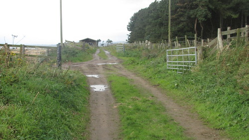
I've been from the Forth Road Bridge to Burntisland on it, or rather the NCN route (number? The Sustrans online map isn't working for me at the moment), which deviates from the coastal path at times (Aberdour and Dalgety Bay notably).
Others have suggested that these deviations aren't necessary and continuing along the coast is possible.
A stretch around Dalgety Bay was unsurfaced forest path, but perfectly doable by Pino/Helios/hybrid - probably unpleasant on a racer!
Robert
Actually, I've logged our route on Map My Ride, which I think can output GPX - PM me if you want access...
Robert
A few comments here -
I've only done east of Dysart, fun, slow, steps, detours.
I like using Geograph for checking out path quality for cycling (or terrain quality for walking).
Here is a search for "fife coastal path":
http://www.geograph.org.uk/search.php?i=29685255
Personally I prefer browsing grid square by grid square, although that could take a while for the coastal path.
150km according to http://www.fifecoastalpath.co.uk/
so could take a while to cycle.
The Coastal Path between St Andrews and Crail runs along the foreshore, not sure how suitable that is for bikes. Pretty scrambly a lot of the way.
We'll have mtb for this so a greater number of surfaces are suitable, though foreshore scrambling doesn't sound great for my suspention seals.
After my mates irationalisation he only has a mtb now...
like using Geograph for checking out path quality for cycling (or terrain quality for walking).
Cool, that looks very handy.
150km according to http://www.fifecoastalpath.co.uk/
so could take a while to cycle.
Over two days thats not very far... he says....
Coastal Path between Crail and St Andrews is do-able, but watch out for the bulls...
There's a steep stair section on the cliff side but no big deal, as by then you'll be used to carrying your bike, after all the pointless stiles you've clambered over along the way.
Worst bit will probably be negotiating walkers near the various towns and villages along the route.
I've not done much of this on bike but walked from East Neuk of Fife to near Leven. I recall bits on the beach but there are plenty of access points so you could with a good map negoticate these.
We did cycle from Tentsmuir to Leuchars last weekend and I would recomend going from Tentsmuir to Leuchars on the road as the stretch south of the woods to the Airfeild is very bumpy and ok with an MTB but perhaps not whilst towing heavy tent laden panniers.
I've done the Tentsmuir stretch, plus the bit from Aberdour to Dalgety Bay. Both fine, though went onto road to Leuchars after the forest; also there are several sets of steps to negotiate twixt Aberdour and Dalgety Bay. Not sure about East Neuk, I have walked certain sections a long while ago and seem to recall it was grassy and quite near cliffs round Pittenweem way...
there are several sets of steps to negotiate twixt Aberdour and Dalgety Bay
We didn't find these, following the cycle route signs - possibly that's why we were directed off the coastal trail itself.
However, the cycle route goes through the housing estates, winding up and over the hill, with the occasional cut through between the houses - not very interesting, and a little difficult to follow - we had to keep a sharp eye out for the next signpost!
Robert
I've walked parts of it many times - St Andrews to Crail, Crail to Pittenweem, Elie to Shell Bay. It's not really suitable for bikes. At it's most extreme the path traverses a series of rock ridges into which steps have been cut - the Chain Walk at Earlsferry - though you can stay on the path above the cliffs. IMO trying to cycle it would mean missing out the best bits.
We didn't find these, following the cycle route signs
Yeah, the cycle route is much simpler, metalled surface most of the way. I've done both. The coastal path is more scenic, beautiful down by the water, but can be muddy in places and has steps: of the wooden batten set into earthen slope kind, mostly.
Comments passed on to my navigator, no bloody way I'm going near that chain walk!
Alternate route from Lower Largo towards Elie is on former railway line, now farm track.


Pittenweem by Cycling Mollie, on Flickr
Caiplie by Crail by Cycling Mollie, on Flickr
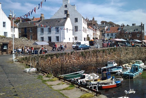
Stalls at Crail Harbour by Cycling Mollie, on Flickr
Crail cafe near the harbour by Cycling Mollie, on Flickr
Kingsbarns Beach by Cycling Mollie, on Flickr
Riding the Forth Coastal Path:
Well we “managed” it.
We tried to stick to the path as much as possible but lost it in places and as noted above large parts of it weren’t really bike able. We left Dundee about 1100 across the Tay bridge which will take two normal bikes if not a monstrous bike.
Tayport to Leuchers was good, well surfaced paths sign posted and not too many stiles. The couple of miles just before Leuchers had some good single track which would probably have been hard work on a rigid bike lots of steep ridged undulations through grassland.
Leuchers to St. Andrews was on pavement running beside the main road, fine but noisy.
We stopped in St. Andrews for some fish and chips for an hour (half of that was cooking time!)
St. Andrews to Crail we took to the road on the advice above and the map. The A917 wasn’t much fun; busy, hilly and fast plus we managed to find a constant head wind, with the off road tyres and luggage we weren’t making a great speed which didn’t help.
At Crail we rejoined the path, after a mile or so it turned into a boulder field that was very difficult to pass, we ended up just walking for a bit. After we passed that and one of the many, many stiles, we hit open grassland again which while rideable the state we were in made it very slow tough going so to get to the B&B before they gave our room away we once again took to the road.
Crail to Elie was on the A917 also, it was about half five so the road was much less busy and had flattened out a bit so was a little less unpleasant. We coasted into the B&B about 1830 roughly 40 miles from Dundee, about 50/50 mix road to non road.
Next morning we headed out of Elie on the path which looked fine but within a couple of miles descended into a sandy path on the dunes. In better condition could have been rideable but we were too tired and not in the mood for getting the pedals stuck every 5m. We decided the beach looked rideable… At best out of the next 5km we managed to ride one!
At Ludin Links (?) we found the path which directed us along a disused railway path and aside from a few pointless, locked, gates was fine.
We parted company from the path again as it looked sandy and overly hard work so hit the road (A915). Pretty busy even for a Sunday morning but had pavement along side most of the way to Leven
From Leven to Kirkcaldy was very industrial along the shore and coupled with the fact we completely lost the path here we were on the road the whole way. Again a lot of pavements on the side if your not making good speed.
We rode along the Kirkcaldy promenade remarkable amount of car parking for no apparent reason. If looking for a nice day out, avoid!
Off road from Kirkcaldy to Kinghorn was a pretty good path only a few stops for stiles, fences and steps.
We got a bit lost at Kinghorn and ended up on the road to Burntisland then we got a little lost again trying to get out of Burntisland after our lunch stop trying to follow NCN route markers but that’s par for the course.
Burntisland to the Bridge was mostly off road and very ridebale, a little busy with walkers mind. After the set of very steep steps over the point at Aberdour the path joined the road but its fairly quiet and only for a short while where it regions the coast through a leafy path which seems to spit out on a commuter estate. After a bit of suburbia in Dalgety bay another off road path takes you to Inverkeithing.
This section is on the slightly busy road through Inverkeithing high street down to the bridge access road, where is pulls off down side road passing some more industry which might be a bit busy with kids. But does eventually go back off road and round to North Queensferry where we left the path to ride over the bridge.
We were picked up about 1730 45 (or so) miles and 6 (ish) hours later, after my riding buddy was done in a started to cramp up and really didn’t want to face the ride out of South Queensferry or Drum Brae!
Would I recommend it? Probably not worth travelling for. If you were staying near one of the better sections it would be a good off road ride but the way we did it was sub-optimal.
The way I like to do it is a leisurely northbound -- camp first evening on the shore just past Ainster, then camp second evening at Tentsmuir Forest, then third day follow the firth along to Newburgh, then cut inland via Auchtermuchty, Star, etc for fast afternoon route back to FRB.
That sounds like a good route, do you only go on the road? First day seems like a much longer day than the second though.
do you only go on the road?
Coastal path as much as possible on day 1 and 2. Including Crail to St Andrews.
First day seems like a much longer day
Yes, big first day and second day morning, nice and easy after St Andrews second day, saving the legs for the inland road home later on day three.
Well Crail to St Andrews on the coastal path is quite an achievement in itself. After the caravans you've got a long section of overgrown gorse and rocky steps, then the golf courses at Balcomie and Kingsbarns, the river at Kenly Green, the cliffs after the rock and spindle. Phew.
I take it the main road is a lot easier, then!
You must log in to post.

 Cycling in Edinburgh Flickr group
Video embedded using Easy Video Embed plugin


 posts
posts