CityCyclingEdinburgh Forum » Leisure

4 Abbeys Cycle Ride

(27 posts)

No tags yet.


  1. Min
    Member

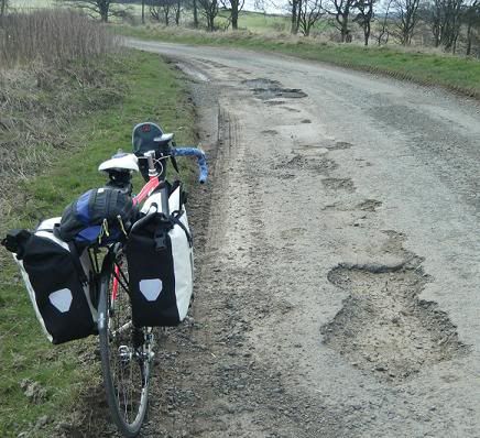
    Just been round the Four Abbeys Cycle Route in the Borders. It is 55 miles and takes in Melrose, Dryburgh, Kelso and Jedburgh Abbeys.

    The route is mixed taking in dirt track and busy A roads with everything in between. Signage was also rather mixed. To begin with, leaving Melrose it is excellent and even has the occasional sign just pointing straight onwards to reassure you that you are on the right track. On leaving Kelso though I found myself off piste by following the sign onwards when I should have turned right. A couple of places even had signs pointing left when you should go right and one turning didn't have a sign at all although there is an alternative route which is longer.

    There are some fairly long climbs but no horrible gradients and since I did it on a road bike with panniers (the trip was organised when I still had my MTB, sniff) I should know. There is a pretty long loop to get from Kelso to Jedburgh but most of that can be cut out if you wish and just requires a little back tracking to get to Jedburgh. The site I linked to recommends taking two days to do it to allow for maximum sightseeing.

    The busier roads could have been potentially unpleasant but I found that drivers were very good and waited behind until it was safe to pass.

    So I would give the route a big thumbs up since it is very picturesque and great cycling. And the abbeys are lovely. I would recommend either taking a GPS and paying close attention or checking your map at turnings after Kelso due to the interesting signage.

    Posted 14 years ago #
  2. chdot
    Admin

    "I would recommend either taking a GPS"

    Did you?

    Will you be uploading track somewhere?

    Posted 14 years ago #
  3. Min
    Member

    Yes I did. I'm not sure about track since I do have a bit of backtracking due to the signs/lack of. Same for the route down to Melrose but I will see what I can do.

    Posted 14 years ago #
  4. wee folding bike
    Member

    My aged GPS, got it in '98, seems to output a standard spread sheet file so it would be possible to delete the errors... time codes would look a bit odd then of course.

    It's possible that the format is different in the machine and MacGPS converts it to a spread sheet.

    Posted 14 years ago #
  5. Kim
    Member

    What is the best way to get to the starting point?

    Posted 14 years ago #
  6. Min
    Member

    Am pretty pleased with the route I picked to get down there, will try to get it up. I have tried to upload and will post the url if it is successfull.

    Posted 14 years ago #
  7. Claggy Cog
    Member

    Melo Velo do this and also the CTC, I believe.

    Posted 14 years ago #
  8. Kim
    Member

    Min, you could just plot it on bikemap.net or some such mapping site ;-)

    Posted 14 years ago #
  9. chdot
    Admin

    My favourite is http://www.everytrail.com - partly because I can upload straight from my iPhone (complete with photos).

    ALSO (useful for removing Min's deviations) it's easy to add or remove waypoints - either due to wrong turns or spurious GPS recordings.

    Posted 14 years ago #
  10. cb
    Member

    "What is the best way to get to the starting point?"

    When/if the railway opens to Gala then that would make a great way to get there.

    Posted 14 years ago #
  11. Min
    Member

    Okay I think I managed to successfully put the route on the Bikemap site suggested my Kim (thanks for all the suggestions folks). If it doesn't link to it directly, search for Edinburgh to Melrose. I started it from North Bridge.

    http://www.bikemap.net/route/454652

    Posted 14 years ago #
  12. Min
    Member

    I mentioned that some of the road surfaces are terrible..

    Posted 14 years ago #
  13. Kim
    Member

    Thanks Min :-)

    I am seriously thinking of giving that a go.

    Posted 14 years ago #
  14. cb
    Member

    On foot there would be a handy shortcut to the obvious dog leg on your route, by following the track/path between NT371565 (on the B7007) and NT401545 (Heriot House).

    Anyone know if this would be rideable, and what kind of bike required?

    Min: were you able to cycle through the ford on the Ale Water?

    Posted 14 years ago #
  15. Min
    Member

    "Min: were you able to cycle through the ford on the Ale Water? "

    Ye gads no. It was quite a bit deeper than in the photo there though I might have tried it on an MTB if I had been with other people. I just carried my bike over the bridge.

    The dog leg on my route is actually pretty cool. It is a long climb with a gentle gradient in both directions. Meaning you can climb up no problem and fly down the other side. I have no idea what the short cut might be like. I didn't even think about attempting it.

    The hill you climb exiting Stow is a different kettle of fish. Long and steep it is probably best tackled on a bike with lots of small gears!

    Kim "I am seriously thinking of giving that a go"

    Go for it. I am really glad I did. I booked in advance so I couldn't chicken out though I was very lucky with the weather, it could have been a far worse experience!

    Posted 14 years ago #
  16. Kim
    Member

    @cb couldn't get your link to work, but found this one.

    Posted 14 years ago #
  17. chdot
    Admin

    "@cb couldn't get your link to work"

    Link correct, geograph site seems to be down.

    (same photo though)

    Posted 14 years ago #
  18. Min
    Member

    After an attempt to ride over the Moorfoot hills this morning (I abandoned the ride after being poured on for over an hour) I realise I have picked a suboptimal route through Lasswade. Instead of turning right along Melville Dykes Road, keep going down the A7 and turn right along Eskbank Road instead, picking up the rest of the route when you get to it.

    Turns out Melville Dykes Road is up a huge hill, then partway down a huge hill, a very sharp left then up another huge hill. Best avoided really.

    I did manage to locate the cycleway this time that I didn't find on my Melrose trip (hence the confusion around this area. Mostly pretty good apart from a section of rough track, mind you if your bike can't handle it, it probably can't handle some of the roads on this route.

    Posted 14 years ago #
  19. Min
    Member

    That's weird, why is half my post missing?

    ADMIN NOTE

    Sorted - did you cut and paste from somewhere?

    Posted 14 years ago #
  20. Min
    Member

    No. Very strange. I did notice it was splitting words as I wrote though.Must have pressed something by accident.

    Posted 14 years ago #
  21. Kim
    Member

    Where abouts is the cycleway you missed the first time? Were you trying to through Gorebridge?

    I went out for a ride yesterday, and have now concluded that most ways south of Dalkeith involve a lot of climbing.

    Posted 14 years ago #
  22. chdot
    Admin

    "most ways south of Dalkeith involve a lot of climbing"

    Aye

    http://tinyurl.com/37ejd8x

    But once you're at the top...

    Have you ever been here?

    http://edinburgh.cyclestreets.net/journey/135560

    Posted 14 years ago #
  23. Min
    Member

    "Where abouts is the cycleway you missed the first time? Were you trying to through Gorebridge?"

    No, there is a spotty green path between Lasswade and Eskbank. Where it takes a right angle I just followed the path up to the A68 then headed back towards Butterfly World.

    &searchp=ids.srf&mapp=map.srf]Streetmap view

    Posted 14 years ago #
  24. Kim
    Member

    @chdot "Have you ever been here?

    http://edinburgh.cyclestreets.net/journey/135560 "

    Not yet it is on the list.

    @Min I think I used that once, the bit by the river is a waste of time as a route (OK for leisure cycling if you don't want to go far), going the opposite way towards Lasswade was of variable quality.

    Posted 14 years ago #
  25. Min
    Member

    Yes it seems to connect up with the Innocent eventually. I will give it a try one day to see what it is like, it may have been improved!

    Posted 14 years ago #
  26. chdot
    Admin

    There's now a free PDF for the 4 Abbeys -

    http://www.visitscottishborders.com/Downloads/4abbeyscycleroute.pdf

    with other routes here

    There's a concerted effort to get more people to tour the Borders by bike (not just for downhill MTBing) - http://www.cyclescottishborders.com and efforts to encourage the local tourism industry to 'think bike'.

    "94% of tourism businesses in the Borders think cycling is currently vital or important to tourism in the Scottish Borders (Recreational Cycling Group, E-Survey of Borders Businesses, Jan 2010)."

    http://www.ourscottishborders.org.uk/?page_id=2390

    Posted 13 years ago #
  27. Kim
    Member

    That's interesting, I was thinking of cycling in the Borders this coming weekend.

    Posted 13 years ago #

RSS feed for this topic

Reply

You must log in to post.


Video embedded using Easy Video Embed plugin