
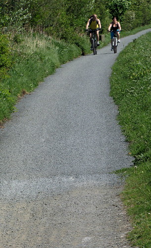
tarmac beyond Hermiston now (and wee stones not down yet) I assume it goes all the way to Ratho. (this is an old string apologies for starting another one).
CityCyclingEdinburgh Forum » Infrastructure
canal path tarmac to Ratho?
(86 posts)-
Posted 16 years ago #
-
it doesn't, runs out at one of the last wee bridges before hand but there were spray painted lines suggesting that it was going to soon
also a nice big "DO NOT HIT" and some arrows pointing at a BT manhole coverPosted 16 years ago # -
I rode out to Livingston via the canal last week and they were digging up the tow path presumably to extend the tarmac, but i think it runs out a fair way before Ratho.
Posted 16 years ago # -
@steveo - until a few days ago it ran out at Hermiston, where if you came off on the tarmac slope up to the bridge and turned left you ended up on A71 at side entrance to Heriot Watt. Beyond this bridge the surface had been scraped in preparation for extension of tarmac. Last night I noticed when I came off at this spot that the tarmac was now laid, and assumed (wrongly) that they had made it to Ratho about another two miles.
Posted 16 years ago # -
The Council has paid for the section to Gogar Station Road, Sustrans is funding from there to just beyond Hermiston House Road. Apparently British Waterways Scotland would like the rest of the towpath to Ratho to be surfaced with tarmac, but doesn't want to spend its own money.
The Council would also like the surface improved but has other priorities for spending cycle money - it has to weigh up the number of people using such paths and also estimate likely increase in cycle use.
Clearly this route is well used from the city to Heriot-Watt and also as a leisure route.
If anyone thinks that many more people would cycle to H-W or The Gyle (for instance) if there was tarmac, they should lobby BW, Sustrans and CEC.
Posted 16 years ago # -
After Hermiston House Rd there are spray paint markings that look like they intend to continue. Here's hoping
Posted 16 years ago # -
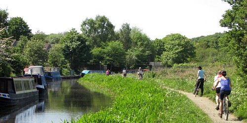
Just in from a lunchtime run along there. Stones run out about a mile towards Ratho after the big Park & Ride roundabout. I don't use the towpath for commuting myself (I like traffic jamming too much) but I run on it frequently.
Posted 16 years ago # -
A guy at work is about to buy his first commuter bike to ride in along the canal (leaving his car at the park and ride).
The fact that it's been tarmacced has been key to this - I'm not sure how he found out about it but was asking me for bike advice yesterday.
With a 5 minute link from the canal to Roseburn, he'll be on the shore for about a mile of road (much of which includes a bus lane). Win.
Posted 16 years ago # -
"ride in along the canal (leaving his car at the park and ride)"
What is it actually like to cycle from PnR at rush hour with that roundabout?
Posted 16 years ago # -
"With a 5 minute link from the canal to Roseburn, he'll be on the shore for about a mile of road (much of which includes a bus lane)."
Which route would that be then? Not the one I'm thinking of, obviously.
Posted 16 years ago # -
Riccarton Mains Rd has a nice pedestiran crossing, then go behind the buildings and the Piano man to get to Gogar Station Rd
Posted 16 years ago # -
"Riccarton Mains Rd has a nice pedestiran crossing"
Aha, not been there for a while...
Not sure that 'box' would be fun if (?) there are lots of pedestrians.
Posted 16 years ago # -
That's OK pedestrians aren't important, the important thing is to make sure that they don't get in the way of the people in cars who are far more important :(
Posted 16 years ago # -
"Which route would that be then? Not the one I'm thinking of, obviously."
If you're referring to "With a 5 minute link from the canal to Roseburn", then probably Harrison Park/Russell Road(?)
Posted 16 years ago # -
"That's OK pedestrians aren't important"
OK I get the irony, I don't mean 'because pedestrians would be in the way'.
IF it is a well used (by pedestrians) crossing, that box is not suitable for shared use.
Hardly suitable for bike use.
Imagine making cars do a very tight Z manoeuvre.
Posted 16 years ago # -
@chdot - There are never lots of pedestrians in that box, they are either on the bus already or walking into Riccarton campus, the box really only serves the wee cluster of houses on the other side of the dual carriageway
@Dave - Good on him, for getting to the shore then yes jump off the canal at Harrison Park and nip down Harrison Road then Ardmillan to get to Murieston Road then Murieston Cres to Russell Rd - pick up the Roseburn path and then a left over the Ferry Rd bridge down to the cycle lane towards the shore... Depending on what bit of the shore you want I have made a map
8.7 miles in length so I reckon he could manage it in under an hour given an average of 15mph and stopping for dog walkers, the aquaduct, general scenery
I put a marker on the map for the Water Of Leith link if he needs to go down to the East shore instead as I sometimes drop down there rather than go round the long way to Trinity. Hope this helps :)Posted 16 years ago # -
"If you're referring to "With a 5 minute link from the canal to Roseburn", then probably Harrison Park/Russell Road(?) "
But there is no bus lane on that route.
Posted 16 years ago # -
true - but it also doesn't take 5 mins
Posted 16 years ago # -
Sorry for the mystery, I was referring to the bit between the end of the Roseburn path and the office, which takes advantage of the bus lane on Commercial St.
And yes, going from canal to Roseburn via Harrison Rd / Ardmillan. Reckon he might soon get tired of dodging people on the canal, as he's quite a young chap (younger than me) but hopefully by then he'll be hooked. I guess he'll be riding against the flow as most will be riding out from the city centre?
Posted 16 years ago # -
Went along canal today - first time in ages.
Bit surprised to find that the tarmac stopped 'in the middle of nowhere'. Looks like 'the money ran out'.
When I reported "Sustrans is funding from there to just beyond Hermiston House Road", I assumed it meant just beyond Hermiston House Road...
 Posted 16 years ago #
 -
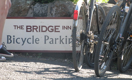
@chdot - thanks for photo it helps with the discussion as I knew that it had been done in stages and used to stop at Hermiston House Road and then as spytfyre and steveo noted it was being prepped for extension beyond this point (which is why I thought it would run to ratho rather than the middle of nowhere).
Posted 16 years ago # -
Went out from Colinton to Falkirk via the canal towpath last Thursday, the largeish stone covering for miles around Broxburn (iirc) was very uncomfortable, I was wishing I'd taken the mountain bike not a hybrid on road tyres, wrists/hands still feel odd! :-/
It would obviously be good to have a better (smoother) surface but a quick improvement would be for local towns/villages to put signs on the towpath indicating where you can leave/rejoin for food, supplies etc. I only saw one in the whole trip and it can be quite difficult to judge when you are near a suitable location.
Posted 16 years ago # -
that's useful info, I had though about taking the hybrid but decided to defer to the MTB for comfort, (also as I can't risk breaking the commute bike for the Monday).
It's a problem that there is no easy place to grab some supplies, I had vague memories of some canal side pubs..
I guess the rule would be - take plenty supplies of your own with you...Posted 16 years ago # -
Two food stops spring to mind, the Bridge Inn at Ratho, and if you going further the Park Bistro just before Linlithgow. Both are cycle friendly ;-)
Posted 16 years ago # -
Linlithgow is a good distance to stop at on the way out and Ratho on the way back in I reckon
Posted 16 years ago # -
Was at Bridge Inn on Saturday afternoon - at least 30 bikes.
Towpath pretty busy. Be nice if there was a better surface...
 Posted 16 years ago #
 -
Yup, Ratho was a bit early in my trip and I wasn't sure how the Bistro would react to a scruff who just wanted some juice and stickies, it looked a bit upmarket! Good to know they are cycle friendly though:)
Does anyone know the actual distance btw? I made it a little over 30m but failed to measure it accurately.
Posted 16 years ago # -
I calculated it at 32 miles with a route planner but someone told me it's more like 34 from lochrin to the wheel
Posted 16 years ago # -
Smudge - largish stone covering for miles around Broxburn - are you saying that they have tarmac-ed the path around Wynchburgh (it has shops but they ain't pretty). This is good news if I read it correctly. The stone chipping eventually sinks into the tarmac -= the route just needs trammelled
Posted 16 years ago #
Reply »
You must log in to post.
 posts
posts
