
http://www.bikebiz.com/news/read/google-maps-bicycling-route-finding-arrives-in-uk/013336
CityCyclingEdinburgh Forum » Computers, GPS, 'Smart' 'Phones
"Google Maps' 'Bicycling' route-finding arrives in UK"
(23 posts)-
Posted 13 years ago #
-
It's worth turning on the 'Bicyling' layer in Google Maps to have a look at their data.
Quite a lot of paths marked, although there are some odd bits such as this strange break in the Innocent path.
Posted 13 years ago # -
Very cool. Wish there was a legend for 'bicycle unfriendly routes' too. My route to work goes past Hillend and after they've messed up the road for the gazzilionth time its definitely gone from cycle friendly to cycle unfriendly.
Posted 13 years ago # -
yup. pretty cool indeed. really shows up what a great (if unjoined up) network we have.
Posted 13 years ago # -
That's fantastic!
How's it compare to cycle streets? It seems to do quite a good job on the routes I've asked.
I think the key needs rephrasing though... Apparently many roads have a 'dedicated lane' (if a piece of road is dedicated to a bike lane, I'd assume it wouldn't have a parking space on it too?). And there seem to be an odd selection of roads considered to be 'bike friendly'.
Posted 13 years ago # -
"How's it compare to cycle streets? "


 Posted 13 years ago #
 -
Just routed my house to my mum's house up at Aberdeen for a ride my brother and I have planned, and it puts you on the A90 for about 10-15 miles heading north from Stonehaven. I think I'll be reporting that one as unsafe for cycling!
Posted 13 years ago # -
Even Spokes' maps have had some funny ideas about cycle-friendliness of streets, seemingly judging some of them on their relative quietness or least-unpleasant-in-the-general-area-ness rather than the cycle-friendliness of their surfaces.
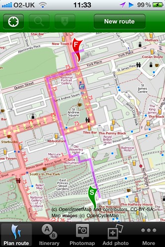
It probably wouldn't have occurred to me to go diagonally across St Andrew's Square on a bike, nor to cut through the gardens next to Waverley Bridge.
Posted 13 years ago # -
Google's algorithms take into account the pavement cyclist's preferred route through St Andrew Square I see...
Posted 13 years ago # -
"this strange break in the Innocent path"
At least reporting seems to be quite easy -
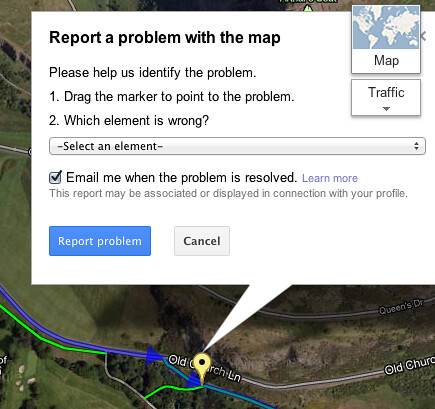
I sent - "Pin at portal of Innocent Tunnel continues (most of rest already mapped green) to East Parkside".
Posted 13 years ago # -
@ Wilnington's Cow from Shetlandic's blog on here and elsewhere there is apparently a path runs alongside the A90 north of Stonehaven but involves accessing by long stretch of drainage rubble ditch thing.
Posted 13 years ago # -
Oh! Interesting, must look out for that next time I'd driving up - that would explain that particular routing!
Posted 13 years ago # -
"from Shetlandic's blog on here and elsewhere there is apparently a path runs alongside the A90 north of Stonehaven but involves accessing by long stretch of drainage rubble ditch thing."
This is the post in question from the Mull2Muckle thread.
("There IS a cycle path by the side of the dual carriageway, on the east side, between Stonehaven and Portlethen")I'm not too clear on where the path is supposed to start.
It must be very new as I can't see any sign of it on Google Streetview, OSM or Sustrans mapping.Posted 13 years ago # -
A quick look determines that the Google Map varient is missing quite a lot of paths that OSM has, and has the disadvantage that you can't just go add them in.
OSM therefore continues to tick the boxes for me in the meantime.
Incidentally, Google Maps has had these cycle paths available to some degree for quite some time. You could see them if, for example, you went to plot a route in Garmin Connect's "courses" utility, for example.
Posted 13 years ago # -
Still think this is useful as an overlay. I've rarely used the 'route-finding' function on googlemaps, and am not sure I would use it much now either.
But we often use googlemaps just to look at stuff with a view to going there, so it would be very handy to be able to see 'ahh there's a cycle path nearby'.
Then I suppose we could choose whether to use googlemaps, cyclestreets, or spokes map to plot our route.
Posted 13 years ago # -
@mkns: Yep, OSM/OCM seem to do far better on detail still. But I'm still very happy that google's added a bike button to its map :) - it's just another little change that might make a few people think of cycling who wouldn't have otherwise.
Posted 13 years ago # -
"
Carlton Reid (@carltonreid)12/07/2012 09:38
Bike Hub planner avoids Old Kent Road: http://bit.ly/N1QtEC RT @realcycling Example of bad Google Bike Route http://goo.gl/maps/TCSj
"
Posted 13 years ago # -
Sustrans and quite a few other "organisations" getting very excited on Twitter about how this will be a revolution etc. As if being on google maps somehow makes a cycle lane that you can park in, or gull of potholes, or with a dangerous design, a better / safer / more user-friendly cycle lane.
I don't think it's nearly as good as the good work done by cyclestreets / OSM. I see it as a bit of a wasted exercise for google to throw it's billions at this in an effort to map cycling infrastructure that has already been mapped by someone else. Also will they be able to respond to how quickly it changes if they aren't an open-project that anyone can update? A cycle map of central Edinburgh that was created even a year or two ago would be very out of date already.
Posted 13 years ago # -
Google already has that problem with 'normal' mapping compared to OSM.
For example Google will direct you on the main round past Haymarket Station, whilst on OSM someone has marked that bit of road as being under construction.
Posted 13 years ago # -
"
Google Maps' cycle routes: just how good are they?
We took to the streets of London to test the new technology and the results were mixed: not bad – but not great either
http://www.guardian.co.uk/environment/bike-blog/2012/jul/12/google-maps-uk-cycle-routes
"
Posted 13 years ago # -
From Private Eye
"
WATERWAYS
Sold up the river
WHAT luck for the Canal and River Trust
WW (CART) charity - attracting one of the
world's biggest companies as corporate partner
just as it takes over care of the canals from the
defunct British Waterways (BW) this month.Google will be helping by "literally putting
towpaths on the map - Google Maps", according to
CART (never mind that towpaths have been on
Ordnance Survey maps, and online service OS
getamap, for years, as well as on specialist map
sites like canalplan and walkit).Perhaps quangos like BW would not have been
so cash-strapped in the first place if some mega-
corporations had paid their fair share of tax. Google
is estimated to avoid £100m in UK corporation tax
by channelling its revenue offshore (Eyes passim).Nevertheless newspapers responded to the
announcement with a slew of feel-good tales about
how nice it was of Google to support summer days
out on the waterways.So how much has Google coughed up for
access to CART's extensive geographical data of
the canals, bridges, locks and towpaths to add to its
Google Maps system? Er, not a penny.The charity proudly told technology website the
Register that Google was paying for the information
simply by, er, "promoting the waterways", while
promising there would be unspecified "exciting and
beneficial initiatives" to follow. None of which
appears to be the most effective way to use its valuable
taxpayer-funded assets to raise funds to pay for the
massive maintenance backlog on the waterways."
Posted 13 years ago # -
This may be old news, but today is the first day I've noticed what appear to be NCN numbers on the main google map.
 Posted 13 years ago #
 -
Only a few days since Apple removed Google maps from iOS. They did replace it with their own version but it's not the same.
Posted 13 years ago #
Reply
You must log in to post.
 posts
posts
