CityCyclingEdinburgh Forum » Infrastructure

Pentlands to Portobello cycle/walk path?

(114 posts)

No tags yet.


  1. kaputnik
    Moderator

    I'm pretty sure that whenever there's any development alongside a railway, NR require an 8 foot tall, anti-climb weldmesh fence to be put up by the developer.

    The new Borders railway is going to give people a lovely view of mile-upon-mile of such fencing.

    Posted 8 years ago #
  2. chdot
    Admin

    "Perhaps that a symptom of them taking safety seriously."

    To some extent, but even busy high speed lines have level crossings - however much NR would prefer a bridge.

    It took years before many half barrier crossings were replaced (years under BR and RailTrack mostly of course.)

    Posted 8 years ago #
  3. chdot
    Admin

    Discussed at Transport Committee

    Councillor Keith Robson (Play Champion
    Labour Councillor for Liberton/Gilmerton)

    'Support from CityCyclingEdinburgh and Spokes'

    'I may even get a bike at the end of it'

    Proposal for committee report approved.

    Posted 8 years ago #
  4. chdot
    Admin

    "

    Nick Cook (@CllrNickCook)
    02/06/2015 12:25
    Delighted to 2nd Cllr @KeithRobson council motion today calling for info on costs & funding for Pentlands to Porty Cycle & Walk way @FBbvp

    "

    Posted 8 years ago #
  5. chdot
    Admin

  6. chdot
    Admin

    "

    Pentlands to Porty Pathway Gets Thumbs Up from Council
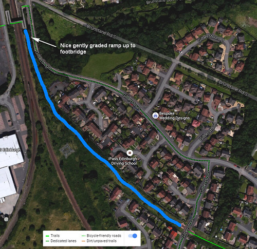
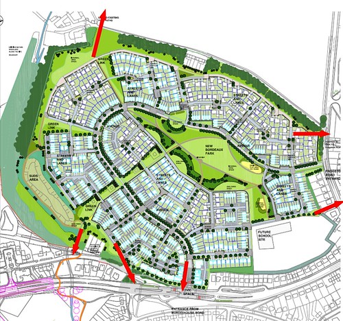
    This month all parties from the council supported a motion put down by local councillor Keith Robson to get a report on the feasibility of creating a walkway and cycleway running the length of the Burdiehouse Burn from Its source in the Pentlands to the sea at Joppa, Portobello. The idea was raised by the Friends after looking at council plans to build new housing at Moredun where there is the possibility of creating an attractive waterside pathway linking the end of Burdiehouse Burn Valley Park to the pathway that runs alongside the New Royal Infirmary.

    The idea has sparked a wide range of interest from various groups with Portobello Community Council getting in touch and Cycling Edinburgh providing valuable information to take the idea forward. Friends of the Pentlands and Spokes have been contacted and are looking at the proposals. Councillor Robson has moved quickly to put together a working group of interested parties to help take the proposals forward. The Friends group has been asked to join this group.

    Clearly, there is a lot to do, but early indications are that the stretch from Burdiehouse to the sea should be relatively straightforward, and the more complex issues involve where the burn crosses the bypass and the A702. The vision is for a corridor for walkers, cyclists and wildlife that connects communities on the south east of the city into the Pentlands and into the network of pathways to and through the south of the city. It is early days, but we're off to an excellent start. Thanks also to the Edinburgh Evening News which gave the project first class coverage, that you can see by clicking this link.

    "

    http://bit.ly/1JC6qfM

    Posted 8 years ago #
  7. neddie
    Member

    Cllr. Keith Robson has organised a meeting/working group to take place in the evening of Tues 22nd Sept. Not sure who is invited...

    Would be good if some CCE/PoP people could attend.

    Posted 8 years ago #
  8. chdot
    Admin

    "Not sure who is invited..."

    You??

    Presume mix of BhB people, CEC staff and GreenSpace +

    I have been and intend to go.

    Posted 8 years ago #
  9. chdot
    Admin

    Went last night.

    Hardly anyone turned up.

    Lot of CEC people on holiday apparently!

    Good look at overview of general situation - inc large of amounts of housing planned for several points along route - might be source of money for improving path.

    Keith left with long list of 'things to do', including 'identity land ownership' at various key points.

    Involvement of http://www.pentlandfriends.org.uk looks good for its experience of Pentland routes/paths which this would link with.

    Posted 8 years ago #
  10. "... might be source of money for improving path"

    Shouldn't look at it as a source of money, but rather put it into the planning requirement for the developer! "Winning bidder must upgrade this path in this way, create a new path here, etc etc"

    Posted 8 years ago #
  11. chdot
    Admin

    "Shouldn't look at it as a source of money, but rather put it into the planning requirement for the developer!"

    Indeed, mostly what l meant. Reality seems to be that some developments are imminent others just 'areas designated for housing' (notably at Brunstane) plus bits where developers are trying to get more houses (near ERI).

    Getting things in planning conditions, sadly, often depends more on 'campaigners' - individuals or groups - than planners.

    This is one area where Spokes has been particularly successful over many years.

    Posted 8 years ago #
  12. But that's the thing, if the councils have targets for sustainable transport etc then it's an easy way to get some decent infrastructure on the ground - it shouldn't take campaigners, it's just common sense. And these are councils we're talking about.

    Just frustrates me that there are so many options out there that can be used, and mean the council doesn't actually have to do certain things itself...

    Posted 8 years ago #
  13. neddie
    Member

    large of amounts of housing planned for several points along route - might be source of money for improving path

    Sadly, judging by past developer-built paths, this means the path will be convoluted, awkward, riddled with chicanes, ramps and other obstacles, difficult to navigate and narrow in sections.

    Oh, and most of it will be on the pavements of the new development, with "Cyclists Dismount" at every junction.

    Posted 8 years ago #
  14. wangi
    Member

    I had been planning to go, but had to send apologies yesterday.

    Posted 8 years ago #
  15. chdot
    Admin

    "But that's the thing, if the councils have targets for sustainable transport etc"

    Yes, well, as 'we' know only too well, such policies don't translate too well into reality across depts/sections.

    When it comes to Planning, apart from being aware of things like the Water of Leith Walkway, planners awareness of 'opportunities' (and making the best of them) is very variable.

    There are places where links/paths have been added, places where they have not been thought of (and made into a condition) and places where developers have 'convinced' planners not to require - eg currently at Donaldson's!

    Posted 8 years ago #
  16. Dave
    Member

    apart from being aware of things like the Water of Leith Walkway

    Although you say that, right now there is a large development going on at the old mill on the WoL, and heavy plant will be on site laying down the latest and greatest in road surfaces, just a few feet away from the mudbath of the path itself...

    The marginal cost to the developer of running half a mile of proper path on their site boundary would be almost zero.

    At the end the path will still be an unlit (described locally as "rapey") mudfest.

    This is Edinburgh.

    Posted 8 years ago #
  17. chdot
    Admin

    The problem with that section of WoL (south of the canal - apart from the bit Sustrans tarmaced) is that 'local opinion' prefers it to have 'rural character' - ie no tarmac, no lights.

    I do not know if opinions have changed in the last 20 years without anyone telling CEC - or not.

    Of course CEC could have said 'look this needs upgrading and we'll get the developers to pay'.

    Posted 8 years ago #
  18. Dave
    Member

    Hmm. As locals, nobody has ever asked us (in the last 2.5 years) whether we prefer queuing in the car on the A70 or having a proper paved and lit cycleway into town.

    However as with all such things it's inevitably a tiny minority speaking into the right ear who control the narrative.

    By anyone's measure it's quite suggestive that a developer is laying tarmac and street lighting meters from a railbed with acknowledged strategic transport value (i.e. which is referenced as a sustainable transport route in developers' housing applications and government planning decisions) and yet nothing is being done to upgrade it.

    However, whatever. If you set off a few minutes earlier it doesn't take that long to drive down Lanark Rd.

    Posted 8 years ago #
  19. kaputnik
    Moderator

    Sadly, judging by past developer-built paths, this means the path will be convoluted, awkward, riddled with chicanes, ramps and other obstacles, difficult to navigate and narrow in sections.

    The splendiferously pointless, unconnected and overengineered cyclepath crossing at Gilbertstoun is a great example of what happens when you leave it to the developers to "build some cycle path" (https://goo.gl/maps/eYsoVYdvw262)

    Posted 8 years ago #
  20. chdot
    Admin

    "what happens when you leave it to the developers to "build some cycle path"

    Presumably planning consent required what's been done - with some notion that CEC would do the rest.

    However CEC openly admits that it doesn't have the resources to check that developments are progressed in line with all aspects of consent.

    Some might say it doesn't have the will.

    Posted 8 years ago #
  21. Klaxon
    Member

    On the subject of Brunstane, I just had a brief page through the LDP and the copy I had (mid 2014) marks out a 'future cycle route' under the railway here. It must have been published around about the same week the bridge was infilled and removed by Network Rail.

    Posted 8 years ago #
  22. chdot
    Admin

    That whole removal/infill saga is a tragedy.

    In short CEC was unwilling to pay what Network Rail wanted for the cost of keeping the route and 'future liabilities'.

    Absolute details depend on who you believe.

    NR says they tried to be helpful and gave CEC 'enough time to come up with a solution'.

    I blame SG/Transport Scotland to some degree. Things like this should just be 'obvious' future 'active travel routes' and Network Rail should be 'obliged' to 'safeguard' with the taxpayers' money they get via SG.

    Posted 8 years ago #
  23. Klaxon
    Member

    In terms of potential through routes it's not as bad as it seems, the pylon corridor through Gilberstoun links up perfectly to old railway parapets at the Range which then would bank round nicely on a lightweight bridge (think Leith Links) to the innocent:

    Obviously expensive but it should rank well on cost/benefit given the amount of housing going in down there AND the university link. Maybe national funding?

    In terms of local shopping links though, a complete disaster, as it means an already grade separated route through to ASDA and the fort was just wiped out with no good alternative route. Better just drive then! /s

    Posted 8 years ago #
  24. neddie
    Member

    Klaxon got there first. My idea was the blue line, but using the existing footbridge (not as expensive):

    brunstane potential path by Ed, on Flickr

    Posted 8 years ago #
  25. chdot
    Admin

    "Obviously expensive"

    and more so than 'preserving' the previous route.

    Would also have possible access to the field at the bottom of your pic.

    This will either remain as a curious bit of 'green belt' or get an even more expensive bit of road access.

    Posted 8 years ago #
  26. Klaxon
    Member

    How much was the Leith Links to Restalrig Path project? The bridge part would actually come in at similar money, notwithstanding the parapets being safe to use and working around a railway rather than a road.

    Laying tarmac down the path itself is peanuts in comparison and I wonder if it was just never done as it would mean 'victory' for the side that didn't pay.

    Posted 8 years ago #
  27. kaputnik
    Moderator

    How much was the Leith Links to Restalrig Path project?

    I have a figure of £1.6m including resurfacing, street lighting, the bridge and building a new embankment at the Links end.

    The cost of just tarmaccing and installing street lighting on the old railway would be about £100 per metre.

    Any bridge over the tracks at Brunstane will require to be higher than what was there before, as trackbed on the current railway has subsequently been raised and overhead electrification catenary installed.

    Posted 8 years ago #
  28. Klaxon
    Member

    On that cost per metre completing through the houses and up to the existing footbridge would come in at around 60k. An acheiveable goal, if I may say so.

    Posted 8 years ago #
  29. chdot
    Admin

    "

    3.9
    Work has been ongoing to specify and cost the QuietRoutes network in outline. As part of this work several additional potential routes have been identified and added to the proposed network map. The map is included as Appendix 3 and highlights the proposed additional routes.

    3.10
    At the June 2015 Transport and Environment Committee, Councillor Keith Robson asked that work be undertaken to consider the costs of a cycle and walking route from the Pentlands to Portobello. This is being undertaken as part of the costing work mentioned in 3.9. A meeting with the Friends of Burdiehouse Burn Park, who are leading efforts to develop the route, has been arranged to discuss potential options for future work.

    "

    From the updated ATAP report.

    http://citycyclingedinburgh.info/bbpress/topic.php?id=15907

    Posted 8 years ago #
  30. chdot
    Admin

    New Barratt development at Burdiehouse, will create 'missing link' between Burdiehouse Village and Mortonhall Estate.

    http://citycyclingedinburgh.info/bbpress/my-templates/peacemaker/images/cycle%20footways.pptx

    Posted 8 years ago #

RSS feed for this topic

Reply »

You must log in to post.


Video embedded using Easy Video Embed plugin