
It is a very long commute even in summer. I don't think very many people would do it. Which is no reason not to have a cycle route of course, just that there won't be many commuters using it.
CityCyclingEdinburgh Forum » Infrastructure
Peebles to Innerleithen
(83 posts)-
Posted 11 years ago #
-
I suspect even if there were a path, most serious commuters would use the road anyway, earning the wrath of various motoring journalists.
I think one of the staff at EBC used to do a Peebles-Edin commute, at least some of the time. That must have been a while ago, mind. I think it was mentioned in the magazine/brochure.
Posted 11 years ago # -
Yes, it is the law in the UK that all cycle routes MUST be slow and inconvenient, even or perhaps especially if they are an old railway line.
Posted 11 years ago # -
cb, that was the legend that was John Galloway. And you also had James Towlson commuting from Aberdour.
Min, you forgot to add those stupid triangular metal gates that stop people on three wheels from using the paths. I think there's one on NCN76 east out of Haddington.
Posted 11 years ago # -
Cycling should be discouraged, cycling on any sort of deviantbike should not even happen at all. Ever.
Posted 11 years ago # -
Arellcat, I worked with James Towlson in Fife before he joined the Bike Co-op. The last time I spoke to him he was setting up a bike parts import business. Mad keen cyclist, no doubt about that. He used to ride in to work in Kirkcaldy from Culross each day.
The surfacing work is continuing:
https://twitter.com/Cyclelaw1/status/307392464531103744/photo/1
Posted 11 years ago # -
bitmac surface most of the way now, with some gaps to fill ...
a few more trees have been removed either side of the bridge ...
probably not enough clearance if they'd left the nearest trees and they swayed in the wind (and their roots were probably damaged by the bridge foundations)
Posted 11 years ago # -
Posted 11 years ago #
-
Oh, that cycle Scottish Borders website is interesting! We were out near Yetholm yesterday and I was interested to see cycle route signs - I'm pretty sure they are associated with the routes on that website.
Posted 11 years ago # -
That "loop 4" route is feasible from Edinburgh if you've got a long day with nice weather and fancy c. 100 miles. We went round most of it on last year's ride that Amir planned. And it was very worth it, some lovely views and tough climbing.
Posted 11 years ago # -
"tough climbing. "
and tough descending (Talla)
Posted 11 years ago # -
I think if I did that route I would do it anti-clockwise. Descending Talla is no fun
Posted 11 years ago # -
We touched a little bit of that route the other week. The section at "Crow wood" is horrendous - I had to stop and take my wheels off (not a joke) to clear the mud and let them turn freely.
See midway down this page.
Definitely one to do counterclockwise. Not so bad going up Talla and then great sweeping descent, rather than long winch uphill followed by 30 seconds on the brakes (with a hairpin at the bottom).
Posted 11 years ago # -
Dave, improvement/proper maintenance of the "crow wood" section (between Lyne and Peebles) is being campaigned for by the local CTC group http://www.mellowvelo.org.uk/brakeaway.html. Officially it is on the SBC List of Roads as the D64/1
For the Peebles-Innerleithen section I should also mention
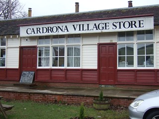 the Village Store in the old station at Cardrona also includes a cafe - now with panini machine and new coffee maker.
Posted 11 years ago #
the Village Store in the old station at Cardrona also includes a cafe - now with panini machine and new coffee maker.
Posted 11 years ago # -
Was the station previously derelict?
Several years since I went that way but don't remember seeing it.
I take it the cycle path doesn't go on the former railway at this point?
Posted 11 years ago # -
Was the station previously derelict?
It was empty but in a semi-well preserved condition for many years, was done up a few years back.
They've built some horrific McMansion housing estate across the trackbed to the Southeast and to the northwest is the equally horrific golf spa retreat thing.
Posted 11 years ago # -
The path hasn't been surfaced yet near the station. There are 2 unsurfaced paths that go either side of the old station, on the former through railway line and on a former siding. Google streetview shows this, from the west go left, into the car park to visit the shop/cafe/bus stop, or go right, along the back to the roundabout. And from the east take the track off the roundabout or take the footway or road to the right to get to the shop/cafe/bus stop. The route through the housing estate is Cardona Way and Leeburn View, before rejoining the line of the railway. There is another part of old line but it is a muddy path used for "walking" dogs.
Posted 11 years ago # -
Is this path safe and fully off main roads for children? I've looked at this route on google and the section from half way from Innerleithen to Gala (A707) looks like it would be a speedway for local cars?
Posted 11 years ago # -
The new path between Peebles and Innerleithen will be mainly off-road apart from a small section though Cardrona. Between Innerleithen and Galashiels the old Tweed Cycleway and NCN 1 are largely on-road, mainly unclassified single track roads which helps keeps drivers' speeds down. But between Yair Bridge and Ashiesteel Bridge the only road available is the A707 which does have some fast traffic on it, either side of Caddonfoot. There is a signed off-road track on the south of the Tweed which allows the A707 to be avoided (apart from the signalled bridge at Yair). I've not been on that track for years and never right along it, but I think it might be more like a forest path in sections.
Posted 11 years ago # -
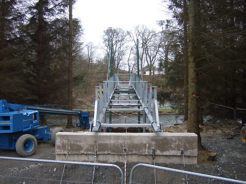
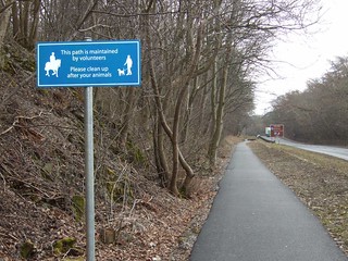
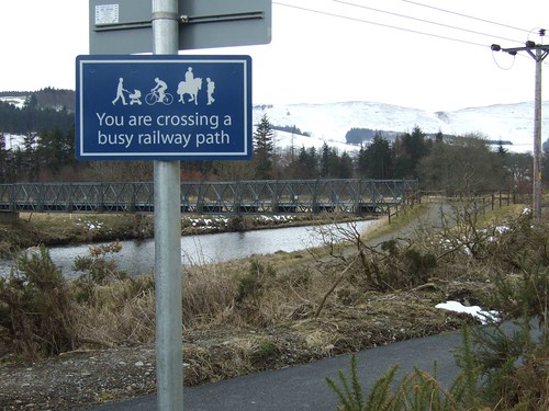
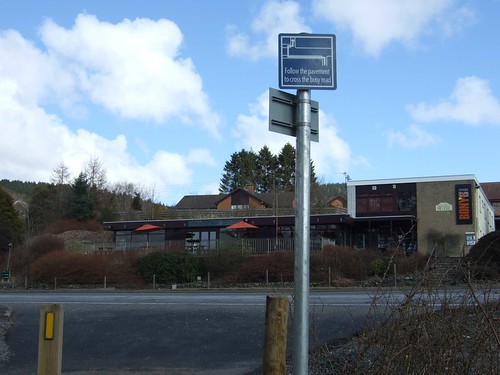
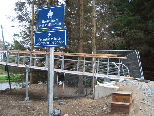
Progress on the bridge seems slow, with still no deck this week. There are a few new (and unusual) signs on the route:
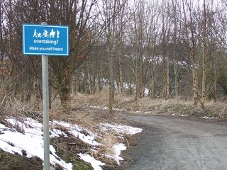
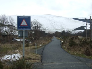
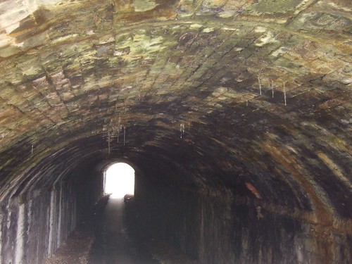
and at the end of March there were icicles in the tunnel:
 Posted 11 years ago #
 -
Icicles or stalactites? You often get the latter in man-made tunnels - must be something in the mortar?
I like the suggestion that horse riders clean up after their animals. I don't think I've ever seen a rider poopascoop...
Posted 11 years ago # -
It's a bit weird that they've chosen to have their own custom signage made.
Posted 11 years ago # -
Thanks for all the photos. It looks as if someone cares and is thinking things through here, which is lovely to see.
Re horses - in Vienna there are a lot of horse-drawn carriages for hire, and I remember seeing horses with poop-catcher bags tied round their nether parts. Very tidy.
Posted 11 years ago # -
I must confess I do like the idea of horse-riders poopscooping - not that they will - I once had a nasty accident on the Water of Leith path near Colinton at night when I hit (in the dark) a large collection of horse manure*. It may have been a softer landing, but that was all it had to recommend it.
*Okay, I should have been going slower, suited my speed to the conditions...etc etc..
Posted 11 years ago # -
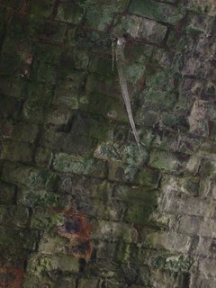
PS - yes icicles. It had been cold and wet and there was still snow lying in shady places. I think a steady wind through the tunnel also 'bent' this icicle -
 Posted 11 years ago #
 -
Cool.
Posted 11 years ago # -
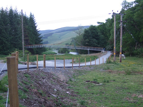
Latest update on the new bridge over the Tweed at Cardrona: it looks pretty much finished apart from the paths either side
The barriers presumably are meant to keep the public out for now, although my defence would have been that there weren't any signs saying keep out, the gap was big enough to walk through (without a bike), and there are several direction signs already in place saying that is the way to Innerleithen.


There are direction signs showing the way on-street through Cardrona and the branch route up to Glentress. The Glentress crossing of the A72 could better, but at least there are warning signs for the main road traffic now.Posted 10 years ago # -
I meant to say that the bridge has been open for a week or two now, without any fanfare or self-publicising councillors in the way.
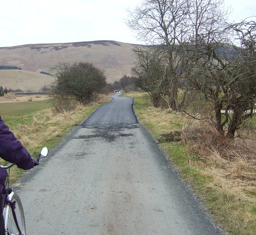
There is 'tarmac' almost all the way between Peebles and Innerleithen, with some sections of dust/gravel.Posted 10 years ago # -
oh great! is it 23 mm tyres-able?
Posted 10 years ago # -
I would think so - I was fine with 27 x 1.25 inch. The roughest part is/was the forestry section from the Hydro and I've bypassed that lately by sticking to the road for the first 500m out of Peebles.
Posted 10 years ago #
Reply »
You must log in to post.
 posts
posts
