CityCyclingEdinburgh Forum » Infrastructure

Peebles to Innerleithen

(83 posts)

  1. cb
    Member

    That looks great, thanks for the photos.
    I swung into Cardrona the other week with the intention of walking along to the bridge, but realised I didn't really have time.

    Has the track through the golf course been upgraded? The Google Streetview car has got a bit carried away and driven down some of it.

    Does it still look like this (assuming this is the route at this point)?:

    http://goo.gl/maps/0kzob

    OSM could do with a bit (ok, a lot) of updating around here.

    Posted 10 years ago #
  2. slowcoach
    Member

    cb - no that bit is tarred. Even the forestry part at Janet's Brae is better than the old railway was in the streetview pics and most of the grit/gravel parts are much smoother.

    Posted 10 years ago #
  3. cb
    Member

    It's a mare.

    "PONY poo and mare mess are driving away tourists from a new link-path between Peebles and Innerleithen, according to locals. "

    http://www.peeblesshirenews.com/news/roundup/articles/2013/07/17/464007-pathway-pony-poo-causes-a-stink/

    Posted 10 years ago #
  4. DaveC
    Member

    You know those council officials who stand near smokers in some cities, watching smokers, waiting for them to drop their fag ends, before pouncing with £50 fines? Well the path could be very easily patrolled by wardens on cycles. They could very easily spot horses and then follow them before fining them for not clearing up their mess as soon as the tail lifts. I'm sure the fines would recoupe the cost of employing someone and they could hire on a temporary basis as once these horsy people realise they'll be fined, they'd 'clean up their act'. Yes!! Horse shoed a pun in there!! :O)

    Posted 10 years ago #
  5. PS
    Member

    In the good old days, folk would be going along that path with a shovel and wheelbarrow and would be rewarded for their efforts with a beautiful rose garden. What's happened to the nation's gardeners?

    Posted 10 years ago #
  6. DaveC
    Member

    Dobbies, funny that as its not dissimilar to a common name for horses!

    Posted 10 years ago #
  7. kaputnik
    Moderator

    I thought the horsey set employed peasants to undertake dung-shovelling duties

    Posted 10 years ago #
  8. Cyclingmollie
    Member

    Come to East Lothian where there are mountains of unwanted horse manure free for the taking. Does anyone grow roses anymore?

    Posted 10 years ago #
  9. chdot
    Admin

    Perhaps it would be theft.

    Belongs to the council(s)?

    Posted 10 years ago #
  10. slowcoach
    Member

    The latest link to be tarred - Janet's Brae leading east from Soonhope at the east entrance to Peebles Hydro - is now finished.

    The start is shared with the drive to a couple of houses so there might be rare car use too.

    Posted 10 years ago #
  11. snowcycle
    Member

    Cardrona cycle path Speed and Signage Problems, but why use the dangerous A702?

    [+] Embed the video | Video DownloadGet the Flash Video

    Posted 10 years ago #
  12. snowcycle
    Member

  13. cb
    Member

    "but why use the dangerous A702?"

    It didn't look like the A702 was being used? The road in the video is the one between the hotel and the village.

    Posted 10 years ago #
  14. slowcoach
    Member

    The A702 is about 10 miles west of Peebles. The A72 goes through Peebles. And the link from the railpath to Glentress crosses it where some traffic will be travelling at 60mph.
    The video shows cyclists crossing/using the B7088 in Cardona. Although the national speed limit now applies the maximum safe speed(and therefore the maximum legal speed?) will be much less than 60mph, and probably less than 30mph. The Council has already agreed to extend the 30mph limit to cover the cycle crossing area. (more to follow)

    Posted 10 years ago #
  15. slowcoach
    Member

    When the road link from the A72 to Cardrona and the B7062 was first opened quite a few years ago, it had a 30mph limit. It was only after the road was classified and numbered the B7088 that the national speed limit automatically applied and the 30mph limit signs were moved away. So it could be seen as strange that the order to re-introduce a 30mph limit doesn't cover all the section that originally had the limit.

    Posted 10 years ago #
  16. amir
    Member

    I am planning to try out this new route this Saturday as part of a circular route, broadly taking in Peebles, Innerleithen and the Moorfoots.

    From Eskbank, that will be around 60 miles. I am planning to start early-ish, mainly so I can get back in time to have a recuperation kip before setting about the garden. Should take in the order of 4 hours.

    I'd be happy for company should any one fancy this route. Uberuce - we could divert past Neidpath Castle.

    Posted 10 years ago #
  17. DaveC
    Member

    I cycled along this path on the Coast 2 Coast last week. Mighty fine path it is too! We also took the Neidpath viaduct and tunnel. Its original stone balast at the moment, so only MTB or wide tyres could cope I would suggest. Lights needed in the tunnel too.

    Posted 10 years ago #
  18. amir
    Member

    Are you doing the Dave Harris audax, Dave? I was wanting to but having seen the forecast, I'm glad I'm not!

    Doesn't the route go from Inneleithen to Peebles and back? Are you going to use the off-road route?

    Posted 10 years ago #
  19. Uberuce
    Member

    I'm heading northwards this weekend, so I'll have to defer, alas.

    Posted 10 years ago #
  20. amir
    Member

    I had a lovely ride today - even seeing the Sky team bus at Eddleston.

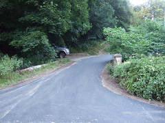
    The cycle path from Peebles to Innerleithen is excellent, offering a worthy and flatter alternative to the two road routes. You can pick it up by proceeding on the main road to Innerleithen. You can pick it up by following a signpost up a wee lane to the left. This takes you on to a pleasant tarmacked path through the woods. This has a tricky and tight double hairpin down a steep slope. Didn't like that bit. At this point you are right next to the main road again - so you can also access the path here.

    It then dives under the road - a bit frightening first time as it's quite steep on concrete and the tunnel is very dark. The next bit is a bit windy until you get on the old train trainline proper and for a while the surface isn't tarmac. I managed it fine with 23 mmm tyres though. The path is then delightful, with good sightlines and next to the river.

    The path is mostly quite narrow so it's probably best to pick your time if you want to go briskly. I went at 9.30am - there were only a few cyclists and dog walkers near the villages. Didn't see any horses and not too much muck.

    So I'd recommend it, particularly if you want to avoid traffic and don't fancy the hilly south road.

    Posted 10 years ago #
  21. Charterhall
    Member

    I need to try this out. I enjoy the hilly south road, it gets very little traffic and provides some great views. But it's always nice to have an alternative. Also I imagine the off road route gets more sunshine than the south road which being on a north facing slope and mostly wooded gets very little. When I rode it a very weeks ago it was quite chilly.

    Posted 10 years ago #
  22. cb
    Member

    Sustrans Scotland (@SustransScot) tweeted at 1:34 PM on Thu, Dec 19, 2013:New route maps installed on #Peebles to #Innerleithen path. Designed by our very own #volunteer Jeremy Cunningham

    https://twitter.com/SustransScot/status/413663546229403648

    Posted 10 years ago #
  23. slowcoach
    Member

    The path between Cardona and the footbridge had some damage during December floods. (some of the finer gravel was washed off the top of loose surface - it was still usable if a little rough). It has been closed this week while work is underway on repairs (or upgrades?).

    Posted 10 years ago #

RSS feed for this topic

Reply

You must log in to post.


Video embedded using Easy Video Embed plugin