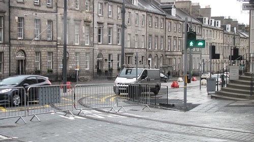
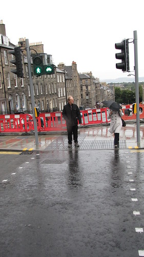
I was doing a bit of shopping after work yesterday and happened to have to cycle from Hanover Street to the St James Centre. Initially I'd thought about cycling to Multrees Walk and pushing my bike through there but as I was going round St Andrew Square I noticed that there was a sign pointing bike users down (the closed) North St Andrew Street. Getting to the bottom of the street there was another sign which suggested to me that I was meant to cycle along the pavement on the south side of York Place. This seemed ludicrous to me so I just got off and pushed but I've honestly no idea where I was meant to go. Anyone know?
CityCyclingEdinburgh Forum » Debate!
Shared Use - the debate (begins) continues
(234 posts)-
Posted 12 years ago #
-
@ianfieldhouse
I asked Jim Orr and Andrew Burns if they could help, and Andrew Burns asked if you could email it in to him: andrew.burns@edinburgh.gov.uk
Do let us know what reply you get.
Posted 12 years ago # -
This -
Posted 12 years ago # -
I believe that is for if you foolishly wish to use NCN75.
It will take three rounds of crossings to be able to get from Dublin Street to N St Andrew St. Once from Dublin St to the central island. Once from there to the other side of Queen St, then another crossing to get across the tram tracks to continue your journey along N St A.
Simples.
Posted 12 years ago # -
Posted 12 years ago #
-
Don't know what you mean?
Posted 12 years ago # -
@ Min
NCN goes straight across (in very convoluted fashion as you say) York Place.
The crossing across the tram tracks just goes to a pavement(?)
Until it's all 'finished' anything is possible (or not).
Posted 12 years ago # -
My interpretation is that it is for cyclists who have come up Dublin Street, crossed York Place by the island and now find themselves with the tramlines to cross to get onto the left lane of N St And St heading south.
As the turn into N St And St from York Place is "Tram Only" as per paint on the floor, I presume that the green man/green bike will be on all the time, except when a tram is approaching.
Posted 12 years ago # -
NCN goes straight across (in very convoluted fashion as you say) York Place.
Yes but it dumps you out on the pavement on the wrong side of the road until you use the third crossing to get to the right side of the road.
Posted 12 years ago # -
Honestly, you have to start thinking like a Edinburgh city planner and not like a normal human being!
Posted 12 years ago # -
@chdot >Cycle crossing to?
That't the one I think. There was a sign near those lights directing me onto the pavement (as far as I could tell) and it may well have had NCN75 on it. I've no idea where the NCN75 is meant to go so it didn't help me.
I mostly cycle in Edinburgh from Craiglockhart to Causewayside and am generally quite satisfied with the provisions for cyclists. Getting home from St James Centre really opened my eyes to how poorly serviced the city centre is. There really does need to be some decent route to enable cyclists to get from one end of Princes Street to another. I wasn't happy cycling Princes Street, George Street or Queen Street at that time of day and so resorted to going home via Abercromby Place / Heriot Row / Melville Street before cutting my way up to the canal via Haymarket and Gardeners Crescent. Lots of frustrated drivers about who were anxious to beat me to the next set of red lights. Glad I don't have to commute this way and made me think whether I would have just been better off cycling up the mound and back home my usual way.
Posted 12 years ago # -
@ianfieldhouse
I either go up the mound, or down broughton to rodney street tunnel and nEPN to russell road. Long way round, but worth it.
did you see my post above with andrew burns' email?
Posted 12 years ago # -
Maybe that cycle crossing is a companion piece to the work of art on Cameron Toll roundabout? That little cycle path network it has which links a no-cycling pavement with a no-cycling tiny traffic island via two Toucan crossings and a few yards of (permanently deserted) cycle path (streetview)
Posted 12 years ago # -
@SRD Yeah, I've emailed him. I'll let you know if I get a response.
Posted 12 years ago # -
I've no idea where the NCN75 is meant to go so it didn't help me.
You are meant to Just Know.
(I don't know where it goes either. There is some sort of sign directing you up Rodney Street which doesn't connect with anything)
I agree that getting through the city centre is a nightmare. When travelling East to West I tend to go along Queen Street which is not as bad as going in the other direction. I don't know if it is the parked cars that tend to keep drivers in the outside lane? The speed they go at is horrifying though. When going the other way I tend to use George Street which is just awful but still better than the alternatives.
Posted 12 years ago # -
@Min
Having checked Edinburgh Cyclestreets route planner it appears I could have gone along Rose Street most of the way and then joined Princes Street briefly before cutting through to the canal via Rutland Square. I honestly had no idea Rose Street was fair game for cyclists and I'm pretty sure all the people walking along it wouldn't know either and I'd just end up pissing people off.
I think in future I'll just take SRD's suggestion of joining the nEPN to Russell road from Broughton.
Posted 12 years ago # -
I find George Street fine - as long as you keep an eye open for parked cars moving off from the central parking bays.
Posted 12 years ago # -
The road surface is especially horrible though.
Yes Rose Street is a pain to cycle along. I wouldn't use it as a through route. I have never seen anyone get pissed off but it is a rat run for motorists too so the odd bike probably isn't much of a problem.
Posted 12 years ago # -
it is a rat run for motorists too
Don't you mean delivery vans making essential and important journeys to resupply Edinburgh's vital retail traders?
Posted 12 years ago # -
Er yes. And co-incidentally in their private cars.
Posted 12 years ago # -
"
Pedestrians and cyclists sharing space that previously was pedestrian only. Yes, that's the answer. Oh and where there isn't anywhere near enough space, take some grass away. to create.....still not enough space.
Don't dare take any space from cars. People in cars are far more important than people on bikes or people who walk. After all, car drivers pay tax that pays for the roads, and we need more roads, because we need more cars and we need more cars because we are all getting lazier and we are getting lazier because we have more roads to drive on, and thus we need to buy a car because it isn't safe to walk as there are too many cars......
"
http://www.magnatom.net/2013/09/glasgows-miles-better-going-back-to-80s.html
Posted 12 years ago # -
"
Sally Hinchcliffe (@sallyhinch)
17/09/2013 22:46
@magnatom when you look at the guidelines, on-carriageway (including kerbed) should be considered before shared use.."
Posted 12 years ago # -
ChdotThe crossing across the tram tracks just goes to a pavement(?)
Keep forgetting to post this but this sign has popped up. For those "in the know" it is directing you across the street and on to the other side of the road, for those who are not, it is directing you east along the pavement on Queen Street. Quality!
Posted 12 years ago # -
Looks like Flickr is just as rubbish as photobucket when it comes to putting photos up..
Link
Posted 12 years ago # -
"Looks like Flickr is just as rubbish as photobucket"
Nah, you just need to 'find' the image URL.
Haven't seen that sign, but just remembered was given an explanation.
West side (pavement) of NStASt is one way for bikes(!)
So if you cycle up from Dublin Street you are supposed to know you are on a Sustrans route, then cross at those lights but NOT onto pavement!!
Posted 12 years ago # -
But if you don't cross onto the pavement, what ARE you supposed to do?
To make things worse, the same sign is on the other side facing the other way but pointing in the same direction. So if you are riding north here, you might notice the sign on the opposite pavement, also pointing east along Queen Street pavement.
Baffled of Edinburgh.
Posted 12 years ago # -
I heard back from the council this afternoon regarding the signage on North St. Andrews Street.
…following an inspection of the site, they can confirm that the advisory Route 75 sign placed on the eastern footway of North St. Andrews Street is facing the wrong direction. They have since contacted the Tram maintenance team who will be rectifying this issue on site.
Grateful thanks to you for bringing this issue to our attention.
That makes a bit more sense then, as I'm assuming the sign will point to the crossing where I presume N75 continues.
Posted 12 years ago # -
Ha! Very good.
Posted 12 years ago # -
Re Seafield St, I don't see the point in the shared path bits outside the cafe and at the other side( the red cycle lane now used as permanent parking for three cars usually anyway (LHS coming down towards Seafield Road). I simply go straight over on the road to Seafield Street rather than going onto the shared path.
Posted 12 years ago # -
I nominate Dunfermline as the shared use path capital of Scotland.
I was truly bewildered at the amount of broad pavement that could be used to cycle on.. so bewildered that I had to use the road before I had toucan fatigue.
Sure it was all best practice and done in the best possible taste.
Posted 12 years ago #
Reply »
You must log in to post.


 posts
posts
