CityCyclingEdinburgh Forum » Leisure

Brunstane and Newcraighall exploration

(21 posts)
  • Started 13 years ago by Arellcat
  • Latest reply from kaputnik

  1. Arellcat
    Moderator

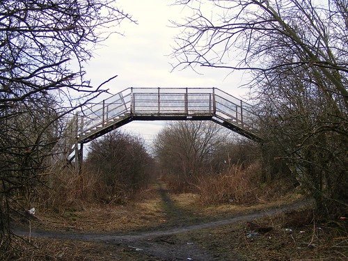
    It's a while since I've been. Was always something of an adventure - former railway embankment with bridge over Newcraighall Road. Used to be 'dangerous' due to underground fires - think they have been bulldozed out of existance. Land is/was owned by Sustrans.
    (from Is it really safer to wear a helmet?)

    I had a look today. Well actually I had a look at the great big locked gate at the southern end of the old embankment, which comes out in what is now the car park of Musselburgh Station. No access from there.

    I cast an eye over the possible entrance off Newcraighall Road but it looked to be private. Of course, the footbridge in chdot's picture is more or less on the join between the Edinburgh and East Lothian Spokes maps, and as I cycled around QMU towards Millerhill, I had forgotten that the bridge was further west along Newcraighall Road. Annoyingly, I would have found it quite easily if I'd taken the right-hand fork on the old railway path from Brunstane/Gilberstoun Loan to N'hall Rd.

    I'll just have to visit the area again, probably once the sun is actually shining.

    Posted 13 years ago #
  2. chdot
    Admin

    "Well actually I had a look at the great big locked gate at the southern end of the old embankment, which comes out in what is now the car park of Musselburgh Station. No access from there."

    Last time I was there access was over low wall at right angles to gate - field side not railway side.

    Time for a trip.

    Posted 13 years ago #
  3. kaputnik
    Moderator

    I've done a lot of googlemapping in this area.

    This overbridge crosses the alignment of the North British Railway's Lothian Lines between Niddrie West Junction (located where an overbridge between the ASDA site and the Fort Kinnaird site cross the current railway lines) and Niddrie East Junction (located immediately to the West of where there is an underbridge - that is where Arrelcat's first link is looking towards).

    This series of railway lines was built to relieve congestion in the area due to the traffic from the mines around Newcraighall and Niddrie.

    So now you know!

    Co-incidentally I was exploring around this area as well today and had myself a wee tour of

    (carefully avoiding the shifty looking characters on quads and dirtbikes)

    Posted 13 years ago #
  4. chdot
    Admin

    "great big locked gate"

    Looks like it was open when Google flew over -

    http://tinyurl.com/3ydatff

    At the other end the Open Street Map data needs fixing.

    This is wrong -

    http://edinburgh.cyclestreets.net/journey/213243

    But this is right -

    http://edinburgh.cyclestreets.net/journey/213244

    (assuming it's still possible to cross over Newcraighall Road on the bridge where double-deck buses sometimes get smaller...)

    Posted 13 years ago #
  5. chdot
    Admin

    Nice afternoon for a ride.

    http://www.everytrail.com/view_trip.php?trip_id=786132

    I'll sort out the OSM info later (it won't appear in CycleStreets immediately.)

    Main thing I found was that the Musselburgh Station car park has got bigger since I was last there (and since the current Google 'satellite" view).

    It really isn't helpful that the big gates don't have some sort of pedestrian bypass.

    Posted 13 years ago #
  6. Arellcat
    Moderator

    Great trail photographing, chdot. For a moment I thought you had managed a little quantum physics dematerialisation and simply walked through the big gate, but I see there's a more prosaic method!

    The cycle path between QMU/Musselburgh Station and Clayknowes Crescent/Newhailes Rd is quite decent, but Newhailes Rd itself can be quite busy and fast; a tarmacked path along the embankment from the station to link up with i) the path from Brunstane and ii) the desire line path under the A1 and westwards to the Jewel footbridge, would be really useful. You could then cycle all the way from Musselburgh Station to St Leonards, or Holyrood, or the Meadows, or even onto the canal and out to Heriot-Watt Uni or Falkirk...barely needing to use a road at all!

    Posted 13 years ago #
  7. chdot
    Admin

    "the desire line path under the A1"

    Which one?

    "barely needing to use a road at all!"

    It's so 'obvious'...

    Perhaps someone should ask ELC why they are 'happy' with the big gates and no ped/cycle access. The crucial part of this route is the (former railway) overbridge. I'm sure there are road engineers who would like to see it removed, but for some reason it hasn't been. The case for keeping it would be a lot stronger if more people were using it...

    I assume the current plan for new housing is the field between Gilberstoun and Newcraighall. I'm sure 'developers' will be keen to build on one or all of the fields between Newcraighall and QM.

    Clearly a 'proper' walk/cycle path/network should be in place long before this.

    Posted 13 years ago #
  8. Arellcat
    Moderator

    Which one?

    From Niddrie South Junction where the path passes underneath the Millerhill-Brunstane line, then west and north to the underpass of the A1 near ASDA and the South Sub, then west to the footbridge. It's a shame that the A1 underpass for the line between Niddrie West and South doesn't have room for a footpath as well.

    Edit: corrected my underpass terminology.

    Posted 13 years ago #
  9. chdot
    Admin

    I've updated the OSM. I don't know if CycleStreets will plan a route along the embankment as I've marked the last section through the field as just an unofficial footpath, without "bicycle = yes".

    Posted 13 years ago #
  10. chdot
    Admin

    "From Niddrie South Junction where the path passes underneath the Millerhill-Brunstane line, then west and north to the underpass of the A1 near ASDA and the South Sub, then west to the footbridge."

    Right

    I was a bit surprised/disappointed to find that there no longer seemed to be a diagonal line through that field, which suggests that not many people are using it now. Since cultivation stopped a few years ago people had been walking (mostly) the most direct route, but I could only find the field boundary paths today.

    I assume that land owners expect to be able to develop this one day either for residential or more retail warehouses.

    Posted 13 years ago #
  11. Cyclingmollie
    Member

    I've started a new thread based on the recent e-mail from Spokes informing members of the consultation on the new housing scheme at Newcraighall and the potential (positive) implications for cycling in that area (NCR1).

    Posted 13 years ago #
  12. kaputnik
    Moderator

    I had a look today, there seems to be a few more steps missing since chdot's photo was taken.

    I was also reminded of

    this.

    Does anyone know if it was/is intended that the route should continue straight on here, rather than deviate through the housing estate? By the effort that the developer has gone in to to provide cycle un-friendly infrastructure on either side of the non-existant cycle path, I assume there was some intention to continue the route through to Brunstane.

    Posted 13 years ago #
  13. Arellcat
    Moderator

    Perhaps the developer hoped (or expected) that the disused bridge abutments across the railway just south of Brunstane station might be reused for pedestrian/cyclist access to Big W/NCN Route 1 from the fancy crossing at Gilberstoun. But given the existing bridge at the station, and the short diversionary route to it, it's not a big problem. I suspect the cost of creating the crossing was little more than it would've been to create the access only to the south. Perhaps the developer was actually pro-walking and cycling (if not fully clued up on the minutia of access infrastructure).

    Posted 13 years ago #
  14. amir
    Member

    Passed by Newcraighall this am on NCN 1. The speed cushions have been removed, leaving a rather bumpy surface. Will these be replaced?

    Posted 13 years ago #
  15. chdot
    Admin

    "The speed cushions have been removed, leaving a rather bumpy surface. Will these be replaced?"

    "
    They were damaged by the snow ploughs before Christmas and are scheduled for replacement (no date yet).

    "

    Posted 13 years ago #
  16. chdot
    Admin

    "Does anyone know if it was/is intended that the route should continue straight on here"

    I'm sure it's on someone's 'when everything else is done wish list'.

    As Arellcat says, there used to be a bridge over the railway. If you look on Google Maps you'll see the remains.

    It would be nice if it had been retained and turned into a path, but it wasn't. The chance of it being re-instated are close to zero. It's a while since I've been there but I think there is quite a steep bank down to Brunstane Road South

    There's a field between the Newcraighall line and the A1 that someone or other will be hoping to build on when the question of access is resolved.

    I think the brickwork and bicycle trap in your photo was done by the Council - this is what it used to look like before 'upgrade'

    Posted 13 years ago #
  17. kaputnik
    Moderator

    As Arellcat says, there used to be a bridge over the railway. If you look on Google Maps you'll see the remains.

    Yes, you can see where the railway / cycle path "should" come out of the bushes on the left here,

    across the NB mainline then down a viaduct / embankment through the Big W carpark and then it was effectively on the alignment of what is now Sir Harry Lauder Road. Even if the bridge were to be re-instated (as unlikely as that is), the missing embankment would be another major engineering issue. You can also see form the photo that it would need to be raised even further, as the OHLE is higher than the level of the where the bridge would have sat.


    You can see part of the bridge parapet to the right (if you clicky to make biggy). The signal box sat on the embankment and controlled access from Niddrie West to both the Lothian Lines and the NB line. Again, all swept away now.

    but I think there is quite a steep bank down to Brunstane Road South

    Indeed there is, first time I ever went that way about 3 or 4 years ago I went straight through (the old street furniture) and ended up fighting my way down, through the thorn bushes. I think the "path" there was definitely one for foxes.

    A quirk of that whole route in general is that it was built after all the other lines so had to be raised up to carry the route over the existing alignments. Large portions of it have now been flattened to reclaim the land for abandoned superstores and car parks. Perhaps the developer / cooncil realised all this after they had shelled out on the ornamental furniture.

    Posted 13 years ago #
  18. cb
    Member

    "Large portions of it have now been flattened to reclaim the land for abandoned superstores and car parks"

    Now, come on - be fair. That's a very important car park. Look how well it was being used when Google visited.

    "but I think there is quite a steep bank down to Brunstane Road South

    Indeed there is, first time I ever went that way about 3 or 4 years ago I went straight through (the old street furniture) and ended up fighting my way down, through the thorn bushes. I think the "path" there was definitely one for foxes."

    Going that way is excusable as you don't know what's to come. I once took a bike up the slope (led by someone else it has to be said).

    Posted 13 years ago #
  19. kaputnik
    Moderator

    Made it along today. Conclusively proved it is possible to cycle from Newcraighall to Musselburgh Station avoiding the silly Queen Margaret University diversion shenanigans and having to pull off the main road back onto the cycle path at a dangerous corner.


    The "missing" bridge at Wanton Walls Junction over Newhailes Road.


    The remaining bridge over Newhailes Road. Got here by turning off Route 1 halfway between Newcraighall and Gilberstoun, turning left towards the "bridge to nowhere" and then heading left again and back towards Newcraighall.

    Made it all the way on the bike but had to walk up the side of the field as the Musselburgh Station car park security fence is too high to climb. Still had to put the bike over a fence and climb to get out.

    Posted 13 years ago #
  20. chdot
    Admin

    "Still had to put the bike over a fence and climb to get out"

    You mean here?

    Is there a new/high fence?

    Posted 13 years ago #
  21. kaputnik
    Moderator

    Yes that's where I climbed out. The other fence would be on your left in that photo. There's a gap where you could squeeze out, but not with a bike and it's too high to get it over there. The car park fence isn't scalable and is much too high.

    Posted 13 years ago #

RSS feed for this topic

Reply

You must log in to post.


Video embedded using Easy Video Embed plugin