CityCyclingEdinburgh Forum » Infrastructure

Newcraighall consultation event Friday 3 September 2010 (Brunstane developments)

(85 posts)
  • Started 13 years ago by Cyclingmollie
  • Latest reply from Cyclingmollie

  1. Cyclingmollie
    Member

    This might be of interest to anyone who uses NCN NCR1 through Newcraighall.

    Dave du Feu has e-mailed Spokes members with details but to briefly paraphrase:

    There are 2 proposals on the go for major housing developments in Newcraighall. These are...

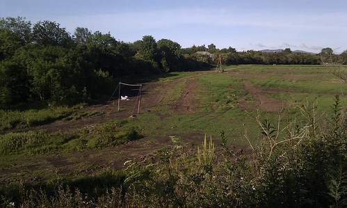
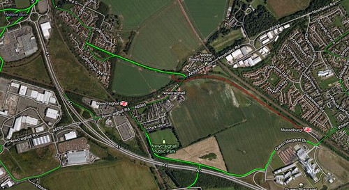
    1. 'Newcraighall East' (PAN number 10/02059/PAN) 8 hectare field behind primary school, south of Newcraighall Road, west of the 'burning bank' disused rail line which leads directly to Musselburgh Station).

    2. 'Newcraighall North' (PAN number 10/01515/PAN) lies to the north of Newcraighall Rd and is bounded on its east side by an old railway, on its west side by a live railway the one that goes to Newcraighall Station), and on the south side by another old railway.

    The most critical thing about both sites is the need for a pedestrian/cycle bridge over Newcraighall Road - either by refurbishing the existing disused rail bridge or more likely by providing a new pedestrian/cycle bridge. This would form part of a direct cycleroute from Edinburgh to Musselburgh, QMU and East Lothian. A bridge would cost a certain amount, but is not a big ask in developments of this scale, and would be of huge benefits to the new residents as well as many other people.

    The developers of both sites say they are working very closely together, so they need to cooperate on this, even though the bulk of the bridge and its connections is in the Newcraighall North area.

    Of course, there are many other issues - accesses between the site and the roads, school, shops, open space etc, bike storage etc. The information online gives no indication on this. Hopefully there will be more info at the exhibition, but comment anyway on all that
    concerns you.

    You can find outline details of both PANs by pasting the entire number e.g. 10/02059/PAN into 'application reference' on this page...

    http://citydev-portal.edinburgh.gov.uk/publicaccess/tdc/DcApplication/application_searchform.aspx

    Then click on 'associated documents.'

    Posted 13 years ago #
  2. chdot
    Admin

    "The most critical thing about both sites is the need for a pedestrian/cycle bridge over Newcraighall Road - either by refurbishing the existing disused rail bridge or more likely by providing a new pedestrian/cycle bridge."

    Haven't looked at the plans yet (your location description was good enough!) so I don't know what is proposed for access, but would agree about need for a bridge.

    I'm sure there will be pressure to remove the bridge and realign the road (who pays?) but a bridge and use of embankment would be desirable for many reasons.

    Posted 13 years ago #
  3. chdot
    Admin

    10/02059/PAN 16/07/2010 Land 263 Metres South Of 104 Newcraighall Road Edinburgh

    "The development proposed includes new housing potential local mixed use facilities together with open space, access and services infrastructure, landscape and footpath/cycle improvements"

    Application Approved

    Associated Documents

    Location Map

    NOTE - development ends at CEC/ELC boundary. The fact that the embankment crosses the councils' boundary makes it harder to have joined-up 'sustainable transport' infrastructure.

    ALSO

    10/01515/PAN 31/05/2010 Land 335 Metres Southwest Of 103 Newcraighall Road Edinburgh

    "The development proposed includes new housing, potential local mixed use facilities together with open space, access and services infrastructure"

    Application Approved

    Associated Documents

    Location Map

    I see that the 'site plan' includes the railway trackbed and the pedestrian footbridge - I wonder if the planners know that it's a filmic icon(?)

    Posted 13 years ago #
  4. Cyclingmollie
    Member

    I forgot to say the consultation is being held at Newcraighall Primary School, Whitehill Street from 2pm - 9pm. (Tomorrow)

    Posted 13 years ago #
  5. kaputnik
    Moderator

    I presume the "greenspace" is being left as such due to the presence of the old coal pit underneath that part of the site. The high voltage pylon line running through the development is bound to be a major selling point.

    Posted 13 years ago #
  6. Cyclingmollie
    Member

    I think round here no subsidence would be a USP.

    Posted 13 years ago #
  7. Cyclingmollie
    Member

    Just back from this. The exhibition seems to be pitched at the residents of Newcraighall. There's a lot of detail on the zoning, housing type, amenities etc. But apart from a short summary of how the development will tie-in with existing sustainable transport (rail, NCN, foootpaths) there's nothing I could see about new paths. The people presenting the plans seemed quite busy fielding questions from concerned locals so I filled in a questionnaire survey form expressing the hope that a bridge and/or an extension to the cycle path from Brunstane to Musselburgh Station could be built.

    Posted 13 years ago #
  8. chdot
    Admin

    "

    Newcraighall East Housing Development (Dalrymple Trust)
    Response to Public Exhibition
    Ref. 10/02059/PAN
     
    Note – the following was hand-written in some haste at the exhibition, and handed in, so the wording leaves something to be desired. Exhibition was held at N'hall Primary School,3 Sept.
     
    Housing [types; mix of private and affordable; your views?]
    Should be high density, to make maximum use of valuable land.
     
    Facilities [extension to new school, in conjunction with EDI who are redeveloping a site at N'hall North; play areas; community facilities]
    N/A
     
    Access [easy reach of train station; boasts ped and cycle routes; improvements?]
    EDI [developers of N'hall North, on N side of N'hall Road, 10/01515/PAN] and Dalrymple should work together to retain and upgrade the “burning bank” old rail route to Musselburgh Station – this could be a “green corridor” fo residents of N'hall East to walk dogs etc, plus be a direct route to QMU and form part of a commuter route to the city.
     
    Environment and Landscape [development will include … a 'green corridor' on the right [eastern] area of the site. Do you support this? Other uses, eg allotments?]
    This plot of land is not a 'corridor' as such – the 'burning bank' line is the real corridor; this piece of land could become allotments, with a path through it to link to 'burning bank'.
     
    Overall assessment [outline main advantages/disadvantages of proposal]
    Reasonably well connected to public transport; has potential for good ped/cycle access (see above). Major disadvantages – this is greenfield land, and Green Belt land, so development here fails to comply with SPP guidelines which emphasise priority on developments within the urban framework, and on use of brownfield land. (N'hall North also fails on these grounds). In addition, with climate change ever present, we should not be giving up agricultural land close to the city.
     
    Any other comments?
    N'hall is poorly provided with shops – means heavy car dependence to get to Asda (nearest supermarket) – unsustainable, unless the path west of the EDI development is upgraded, using u/pass under the A1, for direct pedestrian/cycle route to Asda.
     
    Peter Hawkins
    6 Sept. 2010
     
    Additional note: John Lauder from Sustrans was also present at the exhibition and I had useful discussions with him. Railway Paths Limited (RPL), which is the property owning arm of Sustrans, own the line as far east as the cattle creep. From there to M'burgh Station the owner is Network Rail. RPL also own the abutments and bridge over N'hall Road, which are a liability as well as an asset. EDI have told John that they are not planning to demolish either abutment to put in their access road (although this was contradicted by Dalrymple), and have given John a pretty firm 'no' to the idea of demolition and replacement with a new footbridge over their access road and Newcraighall Road. EDI has, however, given John an indication that the existing bridge could be retained as part of a network of paths it is proposing to construct for its Newcraighall North development. EDI has also shown John proposed paths on the south-side of Newcraighall Rd. These paths were, however, missing from the Dalrymple master-plan and John is to seek an explanation from EDI on what coordination exists between it and Dalrymple. John was not impressed with the Dalrymple proposal and felt it both failed to take mention the new Designing Streets policy and lacked sufficient detail to assess whether its development would encourage or prevent active travel.
     
    Looking towards future developments, Dalrymple are proposing a corridor, possibly to become a road, bisecting their site and running directly towards QMU, in anticipation of a Persimmon development to the south which would complete this route, through to QMU. If this had cycle facilities it could be an alternative, though a much less pleasant one, to the 'burning bank'.
    If ownership of the latter by NR is a problem, the route could be located on Dalrymple land at the foot of the bank by ramping down from the bridge owned by RPL.
     
    The advantages of 'burning bank' are that it is a direct route to QMU from the city; that it takes advantage of a segregated crossing of N'hall Road; that it can be used for recreation by local residents of the new schemes; and that it is partly wooded and pleasant.  We should continue to press for it when the Planning Applications come in.
     
    "

    Posted 13 years ago #
  9. chdot
    Admin

  10. kaputnik
    Moderator

    Judge quashes plan to build new houses on green belt outside Edinburgh

    Lord Malcolm said Edinburgh city councillors had not given clear reasons for their decision to press ahead with building at Newcraighall.

    Posted 13 years ago #
  11. chdot
    Admin

    Oooh

    Very interesting, hadn't seen that.

    Presume it has general 'Green Belt' implications.

    May or may not speed up Scottish Government plans (as well as similar Westminster/English ones) to 'simplify' Planning.

    "
    Lord Malcolm ruled that the council's decision lacked reasoning on key issues. He said the reasons given to go ahead with the building plans were "no more than a series of glib and unsubstantiated assertions".
    "

    They won't like that up 'em!

    Posted 13 years ago #
  12. chdot
    Admin

    "City to fight green belt building ban"

    http://edinburghnews.scotsman.com/topstories/City-to-fight-green-belt.6765727.jp

    Posted 13 years ago #
  13. kaputnik
    Moderator

    So EDI is council owned and planning is in the hands of the council (until higher authorities step in)?

    Conflict of interest?

    Posted 13 years ago #
  14. chdot
    Admin

    It's amazing what you find on YouTube (even when you are not looking) -

    [+] Embed the video | Video DownloadGet the Video Player
    .
    Complete with Brian Taylor soundalike.

    Posted 12 years ago #
  15. kaputnik
    Moderator

    That's fascinating. The old ladies talk like my great aunt did.

    Posted 12 years ago #
  16. cb
    Member

    Very interesting. I wonder who the council chap was, sitting on the large wooden throne.

    Posted 12 years ago #
  17. chdot
    Admin

  18. cb
    Member

    Thanks. That answers the question I had asked myself; "I wonder if he is still around today?".

    Posted 12 years ago #
  19. kaputnik
    Moderator

    I went into the Scottish Mining Museum yesterday and as it was a Sunday, the "BIG MACHINES" tour of the old mining equipment in the warehouse was on. (Recommend to anyone who likes poking about great big hulks of rusting industrial machinery)

    Anyway, our guide Tam "you can call me Young Tam" Young, who had been a civil engineer in the Lothians mines got on to talking about Newcraighall when he was explaining about the subsidence that mining can cause.

    After leaving mining he had been involved in surveying for new housing and at Newcraighall they had to drive boreholes into the ground to locate the old working, inject concrete in to stabilise them and then built the housing development on concrete rafts that floated over the workings. Later developments in the area had not gone to these lengths, said he, resulting in a lot of costly remedial works for cracking walls, roads, pavements and pipes.

    I see that there is a lot of building equipment in the field at Newcraighall penned in by the triangle of old railway lines (between the NCN route and the "bridge to nowhere" route). I also see they've got boring (as in for driving bore holes, not the sort you wouldn't invite to a party) equipment out in the fields.

    Posted 12 years ago #
  20. amir
    Member

    And here is a boring picture

    Posted 12 years ago #
  21. Arellcat
    Moderator

    I also see they've got bore hole equipment out in the fields.

    When coming back from Millerhill the other day I used the path from the disused footbridge to Gilberstoun and Brunstane bridge. The field with the bore holes looked like the intro from Revenge of the Mutant Killer Moles.

    Posted 12 years ago #
  22. Cyclingmollie
    Member

    Why are they doing site tests if the project was blocked?

    Posted 12 years ago #
  23. kaputnik
    Moderator

    Because developers don't know how to take "no" for an answer? Because a few brown envelopes in the right places should get things going again?

    Posted 12 years ago #
  24. chdot
    Admin

    "Because developers don't know how to take "no" for an answer? "

    More or less.

    Developers have long term interests. Apart from the most extreme cases where development will "never" be allowed e.g. (tempting fate) The Meadows, developers know that that 'things change' - individual planning officers, councillors, legislation, 'the climate' etc.

    There will 'always' be a 'need' for 'more houses'. "Green Belt" is far from sacrosanct - and not universally regarded as a 'good thing'.

    As the aphorism goes - "they are not making land anymore". Any suggestions of corruption are of course merely allegations. Some people believe that development is a very good thing.

    Nimbyism is rife and understandable. The problem with places like Newcraighall is that it is marginally (in lots of senses). It has (in the fairly immediate area), a busy dual carriageway a main railway line a massive traffic generating shopping shed area. How much worse can a 'few' houses make it?? It will make sure the primary school survives.

    A few more fields will be 'lost', but they haven't grown crops for a few years (exactly why is another issue...). A particular problem with this area/proposed development is that it's at the border of two councils.

    There is really no long term regional plan that says 'this much/far and no more'. On the Edinburgh side Wimpy was allowed to build Gilberstoun (despite many objections) East Lothian allowed QMU to be built (probably fewer objections). So there is the geographically 'inevitable' pincer. UNLESS there is a strong view that there really should be a green divide between the City of Edinburgh and the rest that has political, and planning law support.

    Developers know that protesters get worn out over the years while they are busy with other developments - e.g. Meggetland. THAT was a highly controversial saga involving councils, a Lord Provost, a rugby club, a developer (went bust some years later). This Is Edinburgh.

    Posted 12 years ago #
  25. Cyclingmollie
    Member

    The new Ikea at Straiton caused a similar "cross border" controversy. The new store serves mainly Edinburgh shoppers but Midlothian had to divert their road transport budget to improving the road network around the store so that they could reach it. At least that's how it was once described to me.

    Posted 12 years ago #
  26. chdot
    Admin

    "

    "Planning officials accepted that the proposals would be "contrary to the development plan as the site is greenfield and is not an allocated for housing in the local plan".  

    However, they said "other material considerations have been taken into account which outweigh the development plan land use allocation".  

    It is understood that planning officials have attempted to justify the approval of the scheme at Newcraighall by arguing that the village would gain "regeneration benefits" - a claim that has been described as "baffling" by the local MP.

    "

    http://edinburghnews.scotsman.com/topstories/Green-belt-housing-plan-to.6787222.jp

    Posted 12 years ago #
  27. chdot
    Admin

    Slightly off-topic, but relevant -

    "The initial response from neighboring mayors toward Apple's unveiling of plans for a massive new campus in Cupertino, Calif., has been positive, despite a history of "border wars" between cities."

    http://appleinsider.com/articles/11/06/19/neighboring_cities_amenable_to_apples_proposed_cupertino_mega_campus.html

    Posted 12 years ago #
  28. neddie
    Member

    Proposed bridge demolition at Newcraighall (action needed)

    A Taylor-Wimpey residential development has been proposed at Newcraighall North, 13/00562/PAN. The developers propose to demolish the disused bridge and trackbed across Newcraighall Rd/Newhailes Rd, here: http://goo.gl/maps/9Myld

    This bridge & trackbed could be used to make a nice and more direct traffic-free route for NCN1 between Brunstane and Queen Margeret College. See picture below (possible route on old trackbed shown in red). Note that the new route would avoid having to wind your way through residential streets and the narrow path through Newcraighall Park.

    The reason the developers/council want to remove the bridge? To remove a ‘bottleneck’ on the already 30mph Newcraighall Rd!

    In fact, the bridge provides a ‘natural’ traffic calming measure, and is also the last remaining historical artefact of mining history in the area.

    Please write to the relevant councillors/object to the planning, to help preserve this bridge and possible traffic free route!

    (Note that cyclestreets.net incorrectly shows this potential cycle route as being complete – see: http://www.cyclestreets.net/journey/1346884/ , look at the “Quietest route”/green line where it crosses Newhailes Rd)


    Newcraighall NCN1 improvement

    Posted 11 years ago #
  29. neddie
    Member

    Note that there are actually two bridges here, one largely complete, the other just consisting of the abutments.

    Posted 11 years ago #
  30. chdot
    Admin

    What I don't understand is why the developers want to spend any money on this.

    My understanding is that the land is owned by EDI (a CEC arms length company).

    http://www.edigroupscotland.co.uk

    Ooh look councillors -

    http://www.edigroupscotland.co.uk/pages/15/Board.html

    Take your pick.

    IF there is any good reason to remove current bridge, MUST be replaced with ped/cycle bridge.

    Posted 11 years ago #

RSS feed for this topic

Reply »

You must log in to post.


Video embedded using Easy Video Embed plugin